Maps of Nordfriesland

[left] FRISIA BOREALIS | IN DVCATV SLESWICENSI | sive FRISIA CIMBRICA | Anno 1651. [right] FRISIA BOREALIS | IN DVCATV SLESWICENSI | Anno 1240. | Frisia Cimbrica Antiqua.
Matthias & Nicolao Peters | Goldtschmide gbr. Husum. sculps. [Amsterdam : Joan Blaeu]

DUCATUS SLESVICENSIS juxta novißimam et accuratißimam Designationem
1 : 325000 Šlesvicko Seutter, Matthäus sumtibus Matth. Seutteri
Ducatus Slesvicensis
1 : 312700 Šlesvicko Homann, Johann Baptist a Ioh. Baptista Homan[n]o
Herzogthum Schleswig
Grosser Hand-Atlas über alle Theile der Erde in 170 Karten Meyer, J. Verlag des Bibliographischen Instituts
Schleswig.
1 : 427000 Gotthard, A.
PARS OCCIDENTALIS | PRÆFECTVRÆ | HADERSLEBEN | cum adjacentibus | RIPEN et LOHMCLOSTER | PRÆFECTVRIS.
Matthias Vnd Clauss Petersen | Goldtschmide gebr. Husumens. sculps. [Amsterdam : Joan Blaeu]
Szleswig
Deutschland Dänemark Regierungsbezirk Schleswig Grenze Wierzbicki, B.
Tönning 20, uit: Special-Karte von Mittel-Europa / nach amtlichen Quellen bearbeitet von W. Liebenow
1 : 300000 titelvariant: W. Liebenow's Mittel-Europa; Annotatie: Titel boven de bladen: W. Liebenow's Mittel-Europa Johannes Wilhelm Liebenow 1822-1897 Frankfurt a. M. : Ludwig Ravenstein
8. Westerland 9. Tondern, uit: Topographische Uebersichtskarte des Deutschen Reiches / herausgegeben v. d. Kartogr. Abt. d. Königl. Preuß. Landesaufnahme
1 : 200000 titelvariant: Topogr. Übersichtskarte des Deutschen Reiches; Annotatie: Titel boven bladen ook: Topogr. Übersichtskarte des Deutschen Reiches; Annotatie geografische gegevens: Op elk blad twee maatstokken: 10 Kilometer = 5,5 cm; 1 geogr. Meile = 3,6 cm; Legenda onder op elk blad Königlich Preußische Landesaufnahme. Kartographische Abtheilung [S.l : Königlich Preußische Landesaufnahme, Kartographische Abtheilung]
Tönning 20, uit: [W. Liebenow's Special-Karte von Mittel-Europa]
1 : 300000 titelvariant: W. Liebenow's Mittel-Europa; Annotatie: Titel boven de bladen: W. Liebenow's Mittel-Europa Johannes Wilhelm Liebenow 1822-1897 Hannover : Hermann Oppermann
PRÆFECTVRA | TONDERN | sine Lundtofft Herde | Anno 1648
Christian Rothgießer | Husum. sculps. [Amsterdam : Joan Blaeu]
Geologische Karte der Insel Sylt und ihrer nächsten Umgebungen / geologisch bearb. durch L. Meyn
1 : 100000 Annotatie: Geeft ook waterdiepten en stroomrichtingen aan; Met aantekening in potlood boven de titel Berlin : [Königl. Preussische geologische Landesanstalt]
Tondern 10, uit: Special-Karte von Mittel-Europa / nach amtlichen Quellen bearbeitet von W. Liebenow
1 : 300000 titelvariant: W. Liebenow's Mittel-Europa; Annotatie: Titel boven de bladen: W. Liebenow's Mittel-Europa Johannes Wilhelm Liebenow 1822-1897 Frankfurt a. M. : Ludwig Ravenstein
3. Lügumkloster, uit: Topographische Uebersichtskarte des Deutschen Reiches / herausgegeben v. d. Kartogr. Abt. d. Königl. Preuß. Landesaufnahme
1 : 200000 titelvariant: Topogr. Übersichtskarte des Deutschen Reiches; Annotatie: Titel boven bladen ook: Topogr. Übersichtskarte des Deutschen Reiches; Annotatie geografische gegevens: Op elk blad twee maatstokken: 10 Kilometer = 5,5 cm; 1 geogr. Meile = 3,6 cm; Legenda onder op elk blad Königlich Preußische Landesaufnahme. Kartographische Abtheilung [S.l : Königlich Preußische Landesaufnahme, Kartographische Abtheilung]
PRÆFECTURA | HVSVMENSIS | LVNDERBERGH NORDSTRAND | et NORDGOESHERDE.
Matthias Vnd Clauss Petersen | G.S. gebr. | Husumenss. sculps. [Amsterdam : Joan Blaeu]
22. Husum, uit: Topographische Uebersichtskarte des Deutschen Reiches / herausgegeben v. d. Kartogr. Abt. d. Königl. Preuß. Landesaufnahme
1 : 200000 titelvariant: Topogr. Übersichtskarte des Deutschen Reiches; Annotatie: Titel boven bladen ook: Topogr. Übersichtskarte des Deutschen Reiches; Annotatie geografische gegevens: Op elk blad twee maatstokken: 10 Kilometer = 5,5 cm; 1 geogr. Meile = 3,6 cm; Legenda onder op elk blad Königlich Preußische Landesaufnahme. Kartographische Abtheilung [S.l : Königlich Preußische Landesaufnahme, Kartographische Abtheilung]
Composite: 37. Bredstedt. (Germany)
1 : 100000 Reichsamt fur Landesaufnahme
PRÆFECTVRÆ | TONDERANÆ | ORA MARITIMA
Matthias & Nicolaus Peters | Goldtschmide gebr. Hus. | sculps. [Amsterdam : Joan Blaeu]
TERRITORIA | EIJDERSTEDE | Everschop | et | Uthholm.
Matthias und Nicolaus Pet. Goldtschmide gebr. | Husum. sculps. [Amsterdam : Joan Blaeu]
Composite: 56. Husum. (Germany)
1 : 100000 Reichsamt fur Landesaufnahme
36. Fohr. (Germany)
1 : 100000 Reichsamt fur Landesaufnahme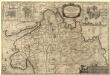
Dithmarsiae Pars Septentrionalis
1 : 75000 Mollova mapová sbírka Mejer, Johannes Peters, Matthias Blaeu, Joan I.
Composite: 36. Fohr. (Germany)
1 : 100000 Reichsamt fur Landesaufnahme
11. Rom. (Germany)
1 : 100000 Reichsamt fur Landesaufnahme
56. Husum. (Germany)
1 : 100000 Reichsamt fur Landesaufnahme
DITHMARSIÆ | PARS SEPTENTRIONALIS [...]
author Iohannes Mejer Husum. | Regæ. Majis. Mathematicus Matthis Pet. v Clauß Peterss Goldtschmide unt gb. Hus. Cimbr. sculp. [Amsterdam : Joan Blaeu]
5. Hvidding. (Germany)
1 : 100000 Reichsamt fur Landesaufnahme
Composite: 5. Hvidding. (Germany)
1 : 100000 Reichsamt fur Landesaufnahme
![[left] FRISIA BOREALIS | IN DVCATV SLESWICENSI | sive FRISIA CIMBRICA | Anno 1651. [right] FRISIA BOREALIS | IN DVCATV SLESWICENSI | Anno 1240. | Frisia Cimbrica Antiqua.](https://images-2.georeferencer.com/images/iiif/794377217001/full/,300/0/native.jpg)

