Maps of Nordfriesland

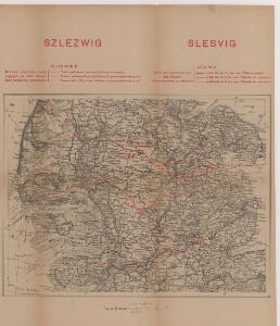
Szleswig
Deutschland Dänemark Regierungsbezirk Schleswig Grenze Wierzbicki, B.
DVCATVS | SLESWICI | PARS MERIDIONALIS.
Matthias undt Nicolaus Peters Goldts. gebr. | Hus. sculps. [Amsterdam : Joan Blaeu]
Schleswig.
1 : 427000 Gotthard, A.
Herzogthum Schleswig
Grosser Hand-Atlas über alle Theile der Erde in 170 Karten Meyer, J. Verlag des Bibliographischen Instituts
Das Herzongthum Schleswig

8. Westerland 9. Tondern, uit: Topographische Uebersichtskarte des Deutschen Reiches / herausgegeben v. d. Kartogr. Abt. d. Königl. Preuß. Landesaufnahme
1 : 200000 titelvariant: Topogr. Übersichtskarte des Deutschen Reiches; Annotatie: Titel boven bladen ook: Topogr. Übersichtskarte des Deutschen Reiches; Annotatie geografische gegevens: Op elk blad twee maatstokken: 10 Kilometer = 5,5 cm; 1 geogr. Meile = 3,6 cm; Legenda onder op elk blad Königlich Preußische Landesaufnahme. Kartographische Abtheilung [S.l : Königlich Preußische Landesaufnahme, Kartographische Abtheilung]
PRÆFECTVRA | TONDERN | sine Lundtofft Herde | Anno 1648
Christian Rothgießer | Husum. sculps. [Amsterdam : Joan Blaeu]
Special-Karte von Süd-Schleswig
1 : 150000 Šlesvicko Petermann, August Justus Perthes
Special-Karte von Süd-Schleswig
1 : 150000 Šlesvicko Petermann, August Friedrich Ehrlich
Special-Karte von Süd-Schleswig
1 : 150000 Šlesvicko Petermann, August Justus Perthes
Geologische Karte der Insel Sylt und ihrer nächsten Umgebungen / geologisch bearb. durch L. Meyn
1 : 100000 Annotatie: Geeft ook waterdiepten en stroomrichtingen aan; Met aantekening in potlood boven de titel Berlin : [Königl. Preussische geologische Landesanstalt]
10. Schleswig, uit: Topographische Uebersichtskarte des Deutschen Reiches / herausgegeben v. d. Kartogr. Abt. d. Königl. Preuß. Landesaufnahme
1 : 200000 titelvariant: Topogr. Übersichtskarte des Deutschen Reiches; Annotatie: Titel boven bladen ook: Topogr. Übersichtskarte des Deutschen Reiches; Annotatie geografische gegevens: Op elk blad twee maatstokken: 10 Kilometer = 5,5 cm; 1 geogr. Meile = 3,6 cm; Legenda onder op elk blad Königlich Preußische Landesaufnahme. Kartographische Abtheilung [S.l : Königlich Preußische Landesaufnahme, Kartographische Abtheilung]
TERRITORIA | ANGLEN | ET | SCHWANSEN | Anno 1649
Matthias und Clauss Petersen Goldtschmide und gebr. | Hus. Cimb. sculps. [Amsterdam : Joan Blaeu]
PRÆFECTVRA | FLENSBVRGENSIS | absque Nordgoeßherde.
Matthias & Nicolas Peters Goldtschmide | gebr. Husum. sculps. [Amsterdam : Joan Blaeu]
PRÆFECTURA | HVSVMENSIS | LVNDERBERGH NORDSTRAND | et NORDGOESHERDE.
Matthias Vnd Clauss Petersen | G.S. gebr. | Husumenss. sculps. [Amsterdam : Joan Blaeu]
Praefectvra Flensbvrgensis absque Nordgoeßherde
1 : 110000 Mollova mapová sbírka Mejer, Johannes Peters, Matthias Blaeu, Joan I.
PRÆFECTVRÆ | GOTTORPIENSIS | pars Borealis.
Matthias und Clauss Petersen | Goldtschmide gebr. Hus. sculps. [Amsterdam : Joan Blaeu]
DVCATVS | SONDERBORG | cum adjacentibus Territoriis | ALSSEN, SVNDEWITT, | et Luxburgh.
Matthis Peterss G.s. v. | Claus P. Goldtschmide unt gbr. | Huss. Cimbr. sculp. [Amsterdam : Joan Blaeu]
Composite: 37. Bredstedt. (Germany)
1 : 100000 Reichsamt fur Landesaufnahme
Nieuwe afteekening van het eijlandt Alsen en de vaste kust daar agter geleegen : vertoonende de rivieren van Apenrader en Flensborgh, is geleegen aen de west kust in de Belt Zee
Denmark Gerard van Keulen
23. Flensburg. (Germany)
1 : 100000 Reichsamt fur Landesaufnahme
Afteekening van de Rivier van Sleeswijck waer bij dessefls incomen int grood wort vertoont geleegen in de Beldt
Germany Gerard van Keulen
56. Husum. (Germany)
1 : 100000 Reichsamt fur Landesaufnahme
38. Schleswig. (Germany)
1 : 100000 Reichsamt fur Landesaufnahme
PRÆFECTVRÆ | TONDERANÆ | ORA MARITIMA
Matthias & Nicolaus Peters | Goldtschmide gebr. Hus. | sculps. [Amsterdam : Joan Blaeu]
TERRITORIA | EIJDERSTEDE | Everschop | et | Uthholm.
Matthias und Nicolaus Pet. Goldtschmide gebr. | Husum. sculps. [Amsterdam : Joan Blaeu]
Composite: 56. Husum. (Germany)
1 : 100000 Reichsamt fur Landesaufnahme
36. Fohr. (Germany)
1 : 100000 Reichsamt fur Landesaufnahme
57. Rendsburg. (Germany)
1 : 100000 Reichsamt fur Landesaufnahme