Maps of Südtondern

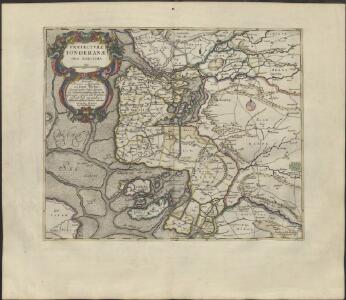
PRÆFECTVRÆ | TONDERANÆ | ORA MARITIMA
Matthias & Nicolaus Peters | Goldtschmide gebr. Hus. | sculps. [Amsterdam : Joan Blaeu]
22. Tondern. (Germany)
1 : 100000 Reichsamt fur Landesaufnahme
Composite: 22. Tondern. (Germany)
1 : 100000 Reichsamt fur Landesaufnahme
Meßtischblatt 162 : Leck, 1895
1 : 250000 Leck. - Aufn. 1878, hrsg. 1880, einz. Nachtr. 1895. - 1:25000. - [Berlin]: Reichsamt für Landesaufnahme, 1895. - 1 Kt.
Meßtischblatt 161 : Deezbüll, 1895
1 : 250000 Deezbüll. - Aufn. 1878, hrsg. 1880, einz. Nachtr. 1895. - 1:25000. - [Berlin]: Reichsamt für Landesaufnahme, 1895. - 1 Kt.
Messtischblatt 126 : Süder-Lügum, 1888 Süder-Lügum
1 : 250000 Süder-Lügum. - Aufn. 1878, hrsg. 1880, einz. Nachtr. 1888. - 1:25000. - [Berlin]: Reichsamt für Landesaufnahme, 1888. - 1 Kt.
Messtischblatt 125 : Neukirchen, 1886 Neukirchen (in Schleswig)
1 : 250000 Neukirchen (in Schleswig). - Aufn. 1878, hrsg. 1880, einz. Nachtr. 1886. - 1:25000. - [Berlin]: Reichsamt für Landesaufnahme, 1886. - 1 Kt.
Meßtischblatt 160 : Midlum, Insel Föhr, 1900
1 : 250000 Midlum, Insel Föhr. - Aufn. 1879, hrsg. 1880, einz. Nachtr. 1900. - 1:25000. - [Berlin]: Reichsamt für Landesaufnahme, 1900. - 1 Kt.
Messtischblatt 124 : Horsbüll, 1930 Horsbüll
1 : 250000 Horsbüll. - Hrsg. 1880, bericht. 1927, teilw. Neuaufn. 1930. - 1:25000. - [Berlin]: Reichsamt für Landesaufnahme, 1930. - 1 Kt.
Messtischblatt 94 : Hoyer, 1895 Hoyer
1 : 250000 Hoyer. - Aufn. 1878, hrsg. 1880, einz. Nachtr. 1895. - 1:25000. - [Berlin]: Reichsamt für Landesaufnahme, 1895. - 1 Kt
Messtischblatt 95 : Tondern, 1895 Tondern
1 : 250000 Tondern. - Aufn. 1878, hrsg. 1880, einz. Nachtr. 1895. - 1:25000. - [Berlin]: Reichsamt für Landesaufnahme, 1895. - 1 Kt.
Messtischblatt : 93 : Rodenäs, 1934 Rodenäs
1 : 250000 Rodenäs. - Nach Luftbildern aufgenommen 1930, bearb. 1931. - 1:25000. - [Berlin]: Reichsamt für Landesaufnahme, 1934. - 1 Kt.
PRÆFECTVRA | TONDERN | sine Lundtofft Herde | Anno 1648
Christian Rothgießer | Husum. sculps. [Amsterdam : Joan Blaeu]
8. Westerland 9. Tondern, uit: Topographische Uebersichtskarte des Deutschen Reiches / herausgegeben v. d. Kartogr. Abt. d. Königl. Preuß. Landesaufnahme
1 : 200000 titelvariant: Topogr. Übersichtskarte des Deutschen Reiches; Annotatie: Titel boven bladen ook: Topogr. Übersichtskarte des Deutschen Reiches; Annotatie geografische gegevens: Op elk blad twee maatstokken: 10 Kilometer = 5,5 cm; 1 geogr. Meile = 3,6 cm; Legenda onder op elk blad Königlich Preußische Landesaufnahme. Kartographische Abtheilung [S.l : Königlich Preußische Landesaufnahme, Kartographische Abtheilung]
Geologische Karte der Insel Sylt und ihrer nächsten Umgebungen / geologisch bearb. durch L. Meyn
1 : 100000 Annotatie: Geeft ook waterdiepten en stroomrichtingen aan; Met aantekening in potlood boven de titel Berlin : [Königl. Preussische geologische Landesanstalt]
21. Hoyer. (Germany)
1 : 100000 Reichsamt fur Landesaufnahme
Composite: 21. Hoyer. (Germany)
1 : 100000 Reichsamt fur Landesaufnahme
Meßtischblatt 163 : Achtrup, 1889
1 : 250000 Achtrup. - Aufn. 1878, hrsg. 1880, einz. Nachtr. 1889. - 1:25000. - [Berlin]: Reichsamt für Landesaufnahme, 1889. - 1 Kt.
Messtischblatt 127 : Ladelund, 1880 Ladelund
1 : 250000 Ladelund. - Aufn. 1878. - 1:25000. - [Berlin]: Reichsamt für Landesaufnahme, 1880. - 1 Kt.
Szleswig
Deutschland Dänemark Regierungsbezirk Schleswig Grenze Wierzbicki, B.
[left] FRISIA BOREALIS | IN DVCATV SLESWICENSI | sive FRISIA CIMBRICA | Anno 1651. [right] FRISIA BOREALIS | IN DVCATV SLESWICENSI | Anno 1240. | Frisia Cimbrica Antiqua.
Matthias & Nicolao Peters | Goldtschmide gbr. Husum. sculps. [Amsterdam : Joan Blaeu]
Das Herzongthum Schleswig

Schleswig.
1 : 427000 Gotthard, A.
Tondern 10, uit: Special-Karte von Mittel-Europa / nach amtlichen Quellen bearbeitet von W. Liebenow
1 : 300000 titelvariant: W. Liebenow's Mittel-Europa; Annotatie: Titel boven de bladen: W. Liebenow's Mittel-Europa Johannes Wilhelm Liebenow 1822-1897 Frankfurt a. M. : Ludwig Ravenstein
Tönning 20, uit: Special-Karte von Mittel-Europa / nach amtlichen Quellen bearbeitet von W. Liebenow
1 : 300000 titelvariant: W. Liebenow's Mittel-Europa; Annotatie: Titel boven de bladen: W. Liebenow's Mittel-Europa Johannes Wilhelm Liebenow 1822-1897 Frankfurt a. M. : Ludwig Ravenstein
Composite: 37. Bredstedt. (Germany)
1 : 100000 Reichsamt fur Landesaufnahme
PRÆFECTURA | HVSVMENSIS | LVNDERBERGH NORDSTRAND | et NORDGOESHERDE.
Matthias Vnd Clauss Petersen | G.S. gebr. | Husumenss. sculps. [Amsterdam : Joan Blaeu]
Composite: 36. Fohr. (Germany)
1 : 100000 Reichsamt fur Landesaufnahme
36. Fohr. (Germany)
1 : 100000 Reichsamt fur Landesaufnahme