Maps of Tønder Municipality

Tondern 10, uit: Special-Karte von Mittel-Europa / nach amtlichen Quellen bearbeitet von W. Liebenow
1 : 300000 titelvariant: W. Liebenow's Mittel-Europa; Annotatie: Titel boven de bladen: W. Liebenow's Mittel-Europa Johannes Wilhelm Liebenow 1822-1897 Frankfurt a. M. : Ludwig Ravenstein
PARS OCCIDENTALIS | PRÆFECTVRÆ | HADERSLEBEN | cum adjacentibus | RIPEN et LOHMCLOSTER | PRÆFECTVRIS.
Matthias Vnd Clauss Petersen | Goldtschmide gebr. Husumens. sculps. [Amsterdam : Joan Blaeu]
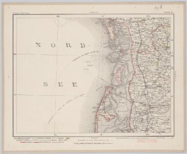
3. Lügumkloster, uit: Topographische Uebersichtskarte des Deutschen Reiches / herausgegeben v. d. Kartogr. Abt. d. Königl. Preuß. Landesaufnahme
1 : 200000 titelvariant: Topogr. Übersichtskarte des Deutschen Reiches; Annotatie: Titel boven bladen ook: Topogr. Übersichtskarte des Deutschen Reiches; Annotatie geografische gegevens: Op elk blad twee maatstokken: 10 Kilometer = 5,5 cm; 1 geogr. Meile = 3,6 cm; Legenda onder op elk blad Königlich Preußische Landesaufnahme. Kartographische Abtheilung [S.l : Königlich Preußische Landesaufnahme, Kartographische Abtheilung]
Geologische Karte der Insel Sylt und ihrer nächsten Umgebungen / geologisch bearb. durch L. Meyn
1 : 100000 Annotatie: Geeft ook waterdiepten en stroomrichtingen aan; Met aantekening in potlood boven de titel Berlin : [Königl. Preussische geologische Landesanstalt]
PRÆFECTVRA | TONDERN | sine Lundtofft Herde | Anno 1648
Christian Rothgießer | Husum. sculps. [Amsterdam : Joan Blaeu]
5. Hvidding. (Germany)
1 : 100000 Reichsamt fur Landesaufnahme
Composite: 5. Hvidding. (Germany)
1 : 100000 Reichsamt fur Landesaufnahme
11. Rom. (Germany)
1 : 100000 Reichsamt fur Landesaufnahme
21. Hoyer. (Germany)
1 : 100000 Reichsamt fur Landesaufnahme
Composite: 11. Rom. (Germany)
1 : 100000 Reichsamt fur Landesaufnahme
Composite: 21. Hoyer. (Germany)
1 : 100000 Reichsamt fur Landesaufnahme
PRÆFECTVRÆ | TONDERANÆ | ORA MARITIMA
Matthias & Nicolaus Peters | Goldtschmide gebr. Hus. | sculps. [Amsterdam : Joan Blaeu]
Composite: 20. Westerland. (Germany)
1 : 100000 Reichsamt fur Landesaufnahme
20. Westerland. (Germany)
1 : 100000 Reichsamt fur Landesaufnahme
Composite: 22. Tondern. (Germany)
1 : 100000 Reichsamt fur Landesaufnahme
Messtischblatt 126 : Süder-Lügum, 1888 Süder-Lügum
1 : 250000 Süder-Lügum. - Aufn. 1878, hrsg. 1880, einz. Nachtr. 1888. - 1:25000. - [Berlin]: Reichsamt für Landesaufnahme, 1888. - 1 Kt.
Messtischblatt 125 : Neukirchen, 1886 Neukirchen (in Schleswig)
1 : 250000 Neukirchen (in Schleswig). - Aufn. 1878, hrsg. 1880, einz. Nachtr. 1886. - 1:25000. - [Berlin]: Reichsamt für Landesaufnahme, 1886. - 1 Kt.
Messtischblatt 124 : Horsbüll, 1930 Horsbüll
1 : 250000 Horsbüll. - Hrsg. 1880, bericht. 1927, teilw. Neuaufn. 1930. - 1:25000. - [Berlin]: Reichsamt für Landesaufnahme, 1930. - 1 Kt.
Messtischblatt 123 : Morsum, 1933
1 : 250000
Messtischblatt 122 : Rantum, 1902 Rantum (Insel Sylt)
1 : 250000 Rantum (Insel Sylt). - Aufn. 1878, hrsg. 1880. - 1:25000. - [Berlin]: Reichsamt für Landesaufnahme, 1902. - 1 Kt.
Messtischblatt 95 : Tondern, 1895 Tondern
1 : 250000 Tondern. - Aufn. 1878, hrsg. 1880, einz. Nachtr. 1895. - 1:25000. - [Berlin]: Reichsamt für Landesaufnahme, 1895. - 1 Kt.
Messtischblatt 94 : Hoyer, 1895 Hoyer
1 : 250000 Hoyer. - Aufn. 1878, hrsg. 1880, einz. Nachtr. 1895. - 1:25000. - [Berlin]: Reichsamt für Landesaufnahme, 1895. - 1 Kt
Messtischblatt : 93 : Rodenäs, 1934 Rodenäs
1 : 250000 Rodenäs. - Nach Luftbildern aufgenommen 1930, bearb. 1931. - 1:25000. - [Berlin]: Reichsamt für Landesaufnahme, 1934. - 1 Kt.
Messtischblatt 92 : Kampen, 1908 Kampen (Insel Sylt)
1 : 250000 Kampen (Insel Sylt). - Aufn. 1878, hrsg. 1880, einz. Nachtr. 1908. - 1:25000. - [Berlin]: Reichsamt für Landesaufnahme, 1908. - 1 Kt.
Messtischblatt 0091 : Westerland (Insel Sylt), 1905
1 : 250000 Westerland (Insel Sylt). - Aufn. 1878, hrsg. 1880, einz. Nachtr. 1905. - 1:25000. - [Berlin]: Reichsamt für Landesaufnahme, 1905. - 1 Kt.
Meßtischblatt 73 : Lügumkloster, 1880
1 : 250000 Lügumkloster. - Aufn. 1878. - 1:25000. - [Berlin]: Reichsamt für Landesaufnahme, 1880. - 1 Kt.
Meßtischblatt 72 : Schads, 1917
1 : 250000 Schads. - Aufn. 1878, hrsg. 1880, Aufldr. 1917. - 1:25000. - [Berlin]: Reichsamt für Landesaufnahme, 1917. - 1 Kt.
Meßtischblatt 71 : Jerpstedt, 1917
1 : 250000 Jerpstedt. - Aufn. 1878, hrsg. 1880, Aufldr. 1917. - 1:25000. - [Berlin]: Reichsamt für Landesaufnahme, 1917. - 1 Kt.
Meßtischblatt 70 : List (Insel Sylt), 1891
1 : 250000 List (Insel Sylt). - Aufn. 1878, hrsg. 1880, einzl. Nachtr. 1891. - 1:25000. - [Berlin]: Reichsamt für Landesaufnahme, 1880. - 1 Kt.