Maps of Tønder Municipality

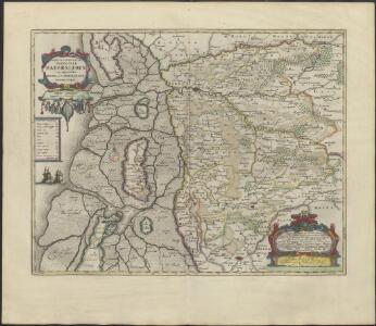
PARS OCCIDENTALIS | PRÆFECTVRÆ | HADERSLEBEN | cum adjacentibus | RIPEN et LOHMCLOSTER | PRÆFECTVRIS.
Matthias Vnd Clauss Petersen | Goldtschmide gebr. Husumens. sculps. [Amsterdam : Joan Blaeu]
3. Lügumkloster, uit: Topographische Uebersichtskarte des Deutschen Reiches / herausgegeben v. d. Kartogr. Abt. d. Königl. Preuß. Landesaufnahme
1 : 200000 titelvariant: Topogr. Übersichtskarte des Deutschen Reiches; Annotatie: Titel boven bladen ook: Topogr. Übersichtskarte des Deutschen Reiches; Annotatie geografische gegevens: Op elk blad twee maatstokken: 10 Kilometer = 5,5 cm; 1 geogr. Meile = 3,6 cm; Legenda onder op elk blad Königlich Preußische Landesaufnahme. Kartographische Abtheilung [S.l : Königlich Preußische Landesaufnahme, Kartographische Abtheilung]
11. Rom. (Germany)
1 : 100000 Reichsamt fur Landesaufnahme
5. Hvidding. (Germany)
1 : 100000 Reichsamt fur Landesaufnahme
Composite: 11. Rom. (Germany)
1 : 100000 Reichsamt fur Landesaufnahme
12. Lugumkloster. (Germany)
1 : 100000 Reichsamt fur Landesaufnahme
Composite: 5. Hvidding. (Germany)
1 : 100000 Reichsamt fur Landesaufnahme
Composite: 12. Lugumkloster. (Germany)
1 : 100000 Reichsamt fur Landesaufnahme
Meßtischblatt 75 : Jordkirch, 1880
1 : 250000 Jordkirch. - Aufn. 1878. - 1:25000. - [Berlin]: Reichsamt für Landesaufnahme, 1880. - 1 Kt.
Meßtischblatt 74 : Bedstedt, 1880
1 : 250000 Bedstedt. - Aufn. 1878. - 1:25000. - [Berlin]: Reichsamt für Landesaufnahme, 1880. - 1 Kt.
Meßtischblatt 73 : Lügumkloster, 1880
1 : 250000 Lügumkloster. - Aufn. 1878. - 1:25000. - [Berlin]: Reichsamt für Landesaufnahme, 1880. - 1 Kt.
Meßtischblatt 72 : Schads, 1917
1 : 250000 Schads. - Aufn. 1878, hrsg. 1880, Aufldr. 1917. - 1:25000. - [Berlin]: Reichsamt für Landesaufnahme, 1917. - 1 Kt.
Meßtischblatt 71 : Jerpstedt, 1917
1 : 250000 Jerpstedt. - Aufn. 1878, hrsg. 1880, Aufldr. 1917. - 1:25000. - [Berlin]: Reichsamt für Landesaufnahme, 1917. - 1 Kt.
Meßtischblatt 70 : List (Insel Sylt), 1891
1 : 250000 List (Insel Sylt). - Aufn. 1878, hrsg. 1880, einzl. Nachtr. 1891. - 1:25000. - [Berlin]: Reichsamt für Landesaufnahme, 1880. - 1 Kt.
Meßtischblatt 55 : Rauberg, 1880
1 : 250000 Rauberg. - Aufn. 1878. - 1:25000. - [Berlin]: Reichsamt für Landesaufnahme, 1880. - 1 Kt.
Meßtischblatt 54 : Toftlund, 1880
1 : 250000 Toftlund. - Aufn. 1878. - 1:25000. - [Berlin]: Reichsamt für Landesaufnahme, 1880. - 1 Kt.
Meßtischblatt 53 : Arrild, 1880
1 : 250000 Arrild. - Aufn. 1878. - 1:25000. - [Berlin]: Reichsamt für Landesaufnahme, 1880. - 1 Kt.
Meßtischblatt 52 : Bröns, 1919
1 : 250000 Bröns. - Aufn. 1878, hrsg. 1880, Nachtr. 1919. - 1:25000. - [Berlin]: Reichsamt für Landesaufnahme, 1919. - 1 Kt.
Meßtischblatt 51 : Kirkeby, 1880
1 : 250000 Kirkeby. - Aufn. 1878. - 1:25000. - [Berlin]: Reichsamt für Landesaufnahme, 1880. - 1 Kt.
Meßtischblatt 50 : Haff-Sand, 1880
1 : 250000 Haff-Sand. - Aufn. 1878. - 1:25000. - [Berlin]: Reichsamt für Landesaufnahme, 1880. - 1 Kt.
Meßtischblatt 37 : Skrydstrup, 1880
1 : 250000 Skrydstrup. - Aufn. 1878. - 1:25000. - [Berlin]: Reichsamt für Landesaufnahme, 1880. - 1 Kt.
Meßtischblatt 36 : Gramm, 1880
1 : 250000 Gramm. - Aufn. 1878. - 1:25000. - [Berlin]: Reichsamt für Landesaufnahme, 1880. - 1 Kt.
Meßtischblatt 35 : Spandet, 1880
1 : 250000 Spandet. - Aufn. 1878. - 1:25000. - [Berlin]: Reichsamt für Landesaufnahme, 1880. - 1 Kt.
Meßtischblatt 34 : Hvidding, 1880
1 : 250000 Hvidding. - Aufn. 1878, hrsg. 1880. - 1:25000. - [Berlin]: Reichsamt für Landesaufnahme, 1880. - 1 Kt.
Meßtischblatt 33 : Hvidding-Ufer, 1880
1 : 250000 Hvidding-Ufer. - Aufn. 1878. - 1:25000. - [Berlin]: Reichsamt für Landesaufnahme, 1880. - 1 Kt.
Meßtischblatt 23 : Jels, 1880
1 : 250000 Jels. - Aufn. 1878. - 1:25000. - [Berlin]: Reichsamt für Landesaufnahme, 1880. - 1 Kt.
Meßtischblatt 22 : Rödding, 1880
1 : 250000 Rödding. - Aufn. 18877/78. - 1:25000. - [Berlin]: Reichsamt für Landesaufnahme, 1880. - 1 Kt.
Meßtischblatt 21 : Hügum, 1878
1 : 250000 Hügum. - Aufn. 1878. - 1:25000. - [Berlin]: Reichsamt für Landesaufnahme, 1878. - 1 Kt.
Messtischblatt 97 : Tingleff, 1914 Tingleff
1 : 250000 Tingleff. - Aufn. 1878, hrsg. 1880, Auflagedr. 1914.. - 1:25000. - [Berlin]: Reichsamt für Landesaufnahme, 1914. - 1 Kt.