Maps of Germany

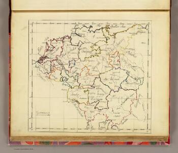
Germany.
1 : 6000000 Bowen, Frances
Imperium Romano-Germanicum in suos circulos electorat. et status accurate distinctum
1 : 2500000 Evropa střední Homann, Johann Baptist J. B. Homann
IMPERIUM ROMANO-GERMANICUM IN SUOS CIRCULOS DIVISUM Geographice exhibitum
1 : 2450000 Evropa střední Homann, Johann Baptist Hübner, Johann a Ioh. Baptista Homanno
[Historisch-geographischer Atlas zu den allgemeinen Geschichtswerken von C. v. Rotteck, Pölitz u. Becker] : Deutschland's frühere kirchliche Eintheilung
von J.V. Kutscheit Lithographie der Herderschen Verlags-Handlung zu Freiburg im Breisgau [Freiburg im Breisgau] : [Herder]
Post Karte durch ganz Deutschland
1 : 2100000 Evropa střední Walch, Johann bey Joh. Walch
Germaniae vulgo Duitschland, tabula comprehendens accuratam X. circulorum Bohemiae Regni ac Universae Helvetiae descriptionem cum divisione in caeteras partes
1 : 2250000 per Ian Bt. Elwe Amstelodami : Ian Bt. Elwe
Neu vermehrte Post Charte durch gantz Teutschland nach Italien, Franckreich, Niederland, Preußen, Polen, und Ungarn &c.

Carte exacte des Postes et Routes de l'Empire d'Allemagne
1 : 2500000 Mollova mapová sbírka Delisle, Guillaume Covens, Johannes I
L'Empire d'Allemagne
1 : 2400000 Mollova mapová sbírka Jaillot, Alexis-Hubert Broen, Gerrit de Jaillot, Alexis Hubert
Charte von Teutschland: Nach dem definitiven Indemnisations-Plane vom 8ten October 1802
1 : 4100000 Landes-Industrie-Comptoir
Homannův atlas světa
1 : 12500000
Neue Postkarte von Deutschland und einem Theile Frankreichs
Německo in Verlage der Schrämblischen Buchdruckerey
Postarum seu veredariorum stationes per Germaniam et provincias adiacentes
Evropa střední Schenk, Pieter Paar, Carl Joseph von Petrus Schenck
Mappa geographica exhibens postas omnes tam vehiculares quam veredarias totius Germaniae
Evropa střední Lotter, Tobias Conrad Tobias Conrad Lotter
Mappa geographica exhibens postas omnes tam vehiculares quam veredarias totius Germaniae
Evropa střední Lotter, Tobias Conrad Tobias Conrad Lotter
Mappa geographica exhibens postas omnes tam vehiculares quam veredarias totius Germaniae
Evropa střední Lotter, Tobias Conrad Tobias Conrad Lotter
Post Charte von Teutschland
1 : 1750000 Evropa střední Güssefeld, Franz L. Geograph. Institut
L Alemagna
1 : 7100000 Evropa střední Zatta, Antonio Zatta
Die Zehen Kraise des H. Römischen Reichs
1 : 3400000 Mollova mapová sbírka
Nova Totivs Germaniae Descriptio
1 : 3500000 Mollova mapová sbírka Walter, A. Walter, Anton
Nova Totivs Germaniae Descriptio
1 : 3300000 Mollova mapová sbírka Blaeu, Willem Janszoon Blaeu, Joan I.
S[anctum] Imperium Romano-Germanicum oder Teutschland Mit Seinen Angräntzenden Königreichen Und Provincien
Reichelt, Julius; Visscher, Nicolaes; Hogeboom, Andries
Neueste Post Karte von Deutschland und dessen angrenzenden Laendern
Evropa střední Walch, Johann Ioh. Walch
Neueste Post Karte von Deutschland und dessen angrenzenden Laendern
Evropa střední Walch, Johann bei Joh. Walch
Neueste Post Karte von Deutschland und dessen angrenzenden Laendern
Evropa střední Knittel, Joh. Ernst Campe, Friedrich Friedrich Campe
Karte von Deutschland nach den Säkularisationen und Entschädigungen des Reichs - Deputations - Schlusses vom 20 November 1802
1 : 2370000 Evropa střední Walch, Johann bei Ioh. Walch
Germania secundum observationes recentissimas in suos circulos divisa
1 : 2313000 Německo Walch, Johann Ioanes Walch
Germania secundum observationes recentissimas in suos circulos divisa
1 : 2313000 Německo Walch, Johann Ioanes Walch
S. Imperium Romano-Germanicum oder Teutschland mit seinen angräntzenden Königreichen und Provincien
1 : 2420000 Evropa střední Reichelt, Julius Hogeboom, A. durch Nicolaum Visscher