Maps of Germany

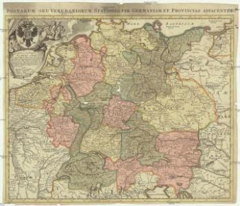
Postarum seu veredariorum stationes per Germaniam et provincias adiacentes
Evropa střední Schenk, Pieter Paar, Carl Joseph von Petrus Schenck
Germaniae = L’empire d’Allemagne distingué suivant l’étendue de tous les estats, principautés et souverainetés qui passent ou qui ont passé jusque a present sous le nom d’Allemagne
1 : 900000 sur les memoires les plus nouveaux de Mss. Sanson, de L'Isle Iaillot, de Fer, &c. A Amsterdam : par I. Cóvens et C. Mortier
Allemagne, distinguée en ses Cercles & subdivisée en ses Etats
1 : 2500000 Mollova mapová sbírka Schatz, Johann Jakob Homann, Johann Baptista - dědici
Tabula geographica totius Germaniae
1 : 2426000 Německo Homann, Johann Baptist J. B. Homann
Karte von Deutschland nach den Säkularisationen und Entschädigungen des Reichs - Deputations - Schlusses vom 20 November 1802
1 : 2370000 Evropa střední Walch, Johann bei Ioh. Walch
Tabula Geographica Totius Germaniae
1 : 2400000 Homann, Johann Baptist
Post Karte durch ganz Deutschland
Evropa střední Walch, Johann Joh. Walch
Neue Post-Karte von Teutschland zum altgemeinen Postbuch von Teutschland
1 : 2000000 Diez, Franz Maximilian 1761-1851 Berlin : C. Jack
[Historisch-geographischer Atlas zu den allgemeinen Geschichtswerken von C. v. Rotteck, Pölitz u. Becker] : Deutschland's frühere kirchliche Eintheilung
von J.V. Kutscheit Lithographie der Herderschen Verlags-Handlung zu Freiburg im Breisgau [Freiburg im Breisgau] : [Herder]

Neu vermehrte Post Charte durch gantz Teutschland nach Italien, Franckreich, Niederland, Preußen, Polen, und Ungarn &c.

Post Karte durch ganz Deutschland
1 : 2100000 Evropa střední Walch, Johann bey Joh. Walch
Deutschland, Niederlande und Schweiz
Hand-Atlas über alle Theile der Erde nach dem neuesten Zustande und über das Weltgebäude Stieler, Adolf bei Justus Perthes
L Alemagna
1 : 7100000 Evropa střední Zatta, Antonio Zatta
Karte der fahrbaren oder im Bau begriffenen und der ernstlich projectirten Eisenbahnen in Deutschland, Belgien und Holland, so wie desgleichen einiger in Frankreich, in der Schweiz, in Italien und in Polen
1 : 2470000 Belgie Müller, Emil bey Hoffmann & Campe
[Recto], uit: Post- und Eisenbahn-Karte von Deutschland, den Niederlanden, Belgien und der Schweiz / bearb. nach L. Friedrich's Post-, Eisenbahn- & Reisekarte von Mittel-Europa
1 : 1800000 Annotatie: Ondertitel op omslag: Bis Calais & Paris, Rügen & Königsberg, Krakau & Pesth, Venedig & Grenoble Gotha : Perthes
Deutschland Niederlande und Schweiz
Stieler's Hand-Atlas Stieler, Adolf bei Justus Perthes
Germaniae vulgo Duitschland, tabula comprehendens accuratam X. circulorum Bohemiae Regni ac Universae Helvetiae descriptionem cum divisione in caeteras partes
1 : 2250000 per Ian Bt. Elwe Amstelodami : Ian Bt. Elwe
Imperium Romano-Germanicum in suos circulos electorat. et status accurate distinctum
1 : 2500000 Evropa střední Homann, Johann Baptist J. B. Homann
IMPERIUM ROMANO-GERMANICUM IN SUOS CIRCULOS DIVISUM Geographice exhibitum
1 : 2450000 Evropa střední Homann, Johann Baptist Hübner, Johann a Ioh. Baptista Homanno
Germania in Circulos Divisa
1 : 4300000 Mollova mapová sbírka Weigel, Christoph Weigel, Christoph I.
(Teutschland, Pohlen, Ungarn, Turcken, Russland)
Hubner, Johann, 1688-1731
Regni Germaniae partium originariarum, ex quibus olim conslatum est facies hodierna ad Circulorum divisionem applicata
1 : 7900000 Mollova mapová sbírka Franz, Johann Michael Homann, Johann Baptista - dědici
L'Empire d'Allemagne
1 : 1200000 Mollova mapová sbírka Sanson, Guillaume Covens, Johannes I
Karte von Central-Europa bis Paris, Mailand, Triest, Pesth, Krakau, Köningsberg, Schleswig, zur Uebersicht der politischen Gestaltung im J. 1867, und der Eisenbahnen und andern Communicationen
1 : 1800000 Annotatie: Bijlage bij: Petermann's geographische Mittheilungen. Ergänzungsheft 19 Gotha : Justus Perthes
Imperii Romano-Germanici
1 : 2400000 Mollova mapová sbírka Schatz, Johann Jakob Homann, Johann Baptista - dědici
Imperii Romano-Germanici
1 : 2400000 Mollova mapová sbírka Schatz, Johann Jakob Homann, Johann Baptista - dědici
Imperium Romano-Germanicum
1 : 2400000 Mollova mapová sbírka Homann, Johann Baptist Homann, Johann Baptista - dědici
Imperium Romano-Germanicum
1 : 2400000 Mollova mapová sbírka Homann, Johann Baptist Homann, Johann Baptista - dědici
Neueste Post Karte von Deutschland und dessen angrenzenden Laendern
Evropa střední Walch, Johann Ioh. Walch
Neueste Post Karte von Deutschland und dessen angrenzenden Laendern
Evropa střední Walch, Johann bei Joh. Walch