Maps of Germany

Post Karte durch ganz Deutschland
Evropa střední Walch, Johann Joh. Walch
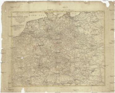
Neueste Post Karte von Deutschland und dessen angrenzenden Laendern
Evropa střední Walch, Johann Ioh. Walch
Neueste Post Karte von Deutschland und dessen angrenzenden Laendern
Evropa střední Walch, Johann bei Joh. Walch
Neueste Post Karte von Deutschland und dessen angrenzenden Laendern
Evropa střední Knittel, Joh. Ernst Campe, Friedrich Friedrich Campe
Neue Post-Karte von Teutschland zum altgemeinen Postbuch von Teutschland
1 : 2000000 Diez, Franz Maximilian 1761-1851 Berlin : C. Jack
Germania secundum observationes recentissimas in suos circulos divisa
1 : 2313000 Německo Walch, Johann Ioanes Walch
Germania secundum observationes recentissimas in suos circulos divisa
1 : 2313000 Německo Walch, Johann Ioanes Walch
S. Imperium Romano-Germanicum oder Teutschland mit seinen Angräntzenden Königreichen und Provincien
1 : 2500000 Mollova mapová sbírka Visscher, Nicolaes Jansz. Hogeboom, Andries Schenk, Peter II
S. Imperium Romano-Germanicum oder Teutschland mit seinen Angräntzenden Königreichen und Provincien
1 : 2500000 Mollova mapová sbírka Schenk, Pieter Hogeboom, Andries Schenk, Peter II
S. Imperium Romano-Germanicum oder Teutschland mit seinen Angräntzenden Königreichen und Provincien
1 : 2500000 Mollova mapová sbírka Schenk, Pieter Hogeboom, Andries Schenk, Peter II
[Recto], uit: Post- und Eisenbahn-Karte von Deutschland, den Niederlanden, Belgien und der Schweiz / bearb. nach L. Friedrich's Post-, Eisenbahn- & Reisekarte von Mittel-Europa
1 : 1800000 Annotatie: Ondertitel op omslag: Bis Calais & Paris, Rügen & Königsberg, Krakau & Pesth, Venedig & Grenoble Gotha : Perthes
Neu vermehrte Post Charte durch gantz Teutschland nach Italien, Franckreich, Niederland, Preußen, Polen, und Ungarn &c.
Deutschland nach den letzten Friedenschlüssen
1 : 3600000 Evropa střední Mollo, Tranquillo bey Tranquillo Mollo
Deutschland nach den letzten Friedenschlüssen
1 : 3600000 Evropa střední Mollo, Tranquillo Tranquillo Mollo

Deutschland Niederlande und Schweiz
Stieler's Hand-Atlas Stieler, Adolf bei Justus Perthes
(Teutschland, Pohlen, Ungarn, Turcken, Russland)
Hubner, Johann, 1688-1731
Regni Germaniae partium originariarum, ex quibus olim conslatum est facies hodierna ad Circulorum divisionem applicata
1 : 7900000 Mollova mapová sbírka Franz, Johann Michael Homann, Johann Baptista - dědici
L'Empire d'Allemagne
1 : 1200000 Mollova mapová sbírka Sanson, Guillaume Covens, Johannes I
Karte von Central-Europa bis Paris, Mailand, Triest, Pesth, Krakau, Köningsberg, Schleswig, zur Uebersicht der politischen Gestaltung im J. 1867, und der Eisenbahnen und andern Communicationen
1 : 1800000 Annotatie: Bijlage bij: Petermann's geographische Mittheilungen. Ergänzungsheft 19 Gotha : Justus Perthes
Deutschland, Niederlande und Schweiz
Hand-Atlas über alle Theile der Erde nach dem neuesten Zustande und über das Weltgebäude Stieler, Adolf bei Justus Perthes
Neu vermehrte Post Charte durch gantz Teutschland nach Italien Franckreich Niederland Preussen Polen und Ungarn etc
1 Karte : Kupferdruck ; 44 x 55 cm Nell von Nellenberg; Homann Homaennische Erben?
Neu-vermehrte Post-Charte durch gantz Teutschland nach Italien, Franckreich, Niederland, Preussen, Polen und Ungarn etc
1 Karte : Kupferdruck ; 45 x 57 cm Nell von Nellenberg; Homann Johann Baptist Homann
Post Karte durch ganz Deutschland
1 : 2100000 Evropa střední Walch, Johann bey Joh. Walch
Karte der fahrbaren oder im Bau begriffenen und der ernstlich projectirten Eisenbahnen in Deutschland, Belgien und Holland, so wie desgleichen einiger in Frankreich, in der Schweiz, in Italien und in Polen
1 : 2470000 Belgie Müller, Emil bey Hoffmann & Campe
Reise Charte durch Deutschland
1 : 7400000 Mollova mapová sbírka Schreiber, Johann Georg Schreiber, Johann Georg
Germania Seraphico-Observans seu Provinciae Fratrum Minorum strictioris Observantiae, in Germania sitae
1 : 2700000 Mollova mapová sbírka Seutter, Matthäus Seutter, Albrecht Carl Seutter, Matthäus
Carte exacte des Postes et Routes de l'Empire d'Allemagne
1 : 2500000 Mollova mapová sbírka Delisle, Guillaume Covens, Johannes I
Post Charte von Teutschland
1 : 1750000 Evropa střední Güssefeld, Franz L. Geograph. Institut