Maps of Germany

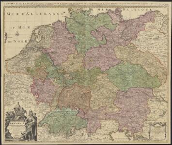
Germaniae = L’empire d’Allemagne distingué suivant l’étendue de tous les estats, principautés et souverainetés qui passent ou qui ont passé jusque a present sous le nom d’Allemagne
1 : 900000 sur les memoires les plus nouveaux de Mss. Sanson, de L'Isle Iaillot, de Fer, &c. A Amsterdam : par I. Cóvens et C. Mortier
Deutschland, Niederlande und Schweiz
Hand-Atlas über alle Theile der Erde nach dem neuesten Zustande und über das Weltgebäude Stieler, Adolf bei Justus Perthes
Allemagne, distinguée en ses Cercles & subdivisée en ses Etats
1 : 2500000 Mollova mapová sbírka Schatz, Johann Jakob Homann, Johann Baptista - dědici
Deutschland Niederlande und Schweiz
Stieler's Hand-Atlas Stieler, Adolf bei Justus Perthes
Karte von Deutschland nach den Säkularisationen und Entschädigungen des Reichs - Deputations - Schlusses vom 20 November 1802
1 : 2370000 Evropa střední Walch, Johann bei Ioh. Walch

Germania Seraphico-Observans seu Provinciae Fratrum Minorum strictioris Observantiae, in Germania sitae
1 : 2700000 Mollova mapová sbírka Seutter, Matthäus Seutter, Albrecht Carl Seutter, Matthäus
Nova totius Germaniae Descriptio Teütschland
1 : 4300000 Mollova mapová sbírka Merian, Matthaeus Merian, Matthäus
Karte von Central-Europa bis Paris, Mailand, Triest, Pesth, Krakau, Köningsberg, Schleswig, zur Uebersicht der politischen Gestaltung im J. 1867, und der Eisenbahnen und andern Communicationen
1 : 1800000 Annotatie: Bijlage bij: Petermann's geographische Mittheilungen. Ergänzungsheft 19 Gotha : Justus Perthes
Tabula geographica totius Germaniae
1 : 2426000 Německo Homann, Johann Baptist J. B. Homann
L Alemagna
1 : 7100000 Evropa střední Zatta, Antonio Zatta
Teutschland die Niederlande und die Schweiz
1 : 2860000 Nizozemsko Streit, Friedrich Wilhelm Boreux, J. J. C. Hinrichssche Buchhandlung
Karte von Deutschland in XVI Blätt
1 : 1000000 nach des H.O.C. Büsching Erdbeschreibung u. den besten Hülfsmitteln entworffen und jetzt nach den neuesten Friedens-Schlüssen gänzlich umgeändert von D.F. Sotzmann J.W. Meil inv. ; C. Jäck sculp. Berlin : In Verlag der K. P. Ac. Kunst- und Buchhandlung von Simon Schropp & Co
Germania in Circulos Divisa
1 : 4300000 Mollova mapová sbírka Weigel, Christoph Weigel, Christoph I.
Peraccurata S. Romani Imperii Tabula, comprehendens Regiones vulgo sub Nomine Germaniae Nuncupantes
1 : 2100000 Mollova mapová sbírka Visscher, Nicolaes Jansz. Schenk, Peter II
Tabula Geographica Totius Germaniae
1 : 2400000 Homann, Johann Baptist
Imperii Romano-Germanici
1 : 2400000 Mollova mapová sbírka Schatz, Johann Jakob Homann, Johann Baptista - dědici
Imperii Romano-Germanici
1 : 2400000 Mollova mapová sbírka Schatz, Johann Jakob Homann, Johann Baptista - dědici
Imperium Romano-Germanicum
1 : 2400000 Mollova mapová sbírka Homann, Johann Baptist Homann, Johann Baptista - dědici
Imperium Romano-Germanicum
1 : 2400000 Mollova mapová sbírka Homann, Johann Baptist Homann, Johann Baptista - dědici
Mappa chorographica Omnivm Episcopatvvm Germaniae ab AC. MD ad MDCCLX existentium
1 : 2600000 Mollova mapová sbírka Hartzheim, Josephus Homann, Johann Baptista - dědici
Hydrographia Germaniae
1 : 2400000 Mollova mapová sbírka Zollmann, Philipp Heinrich Homann, Johann Baptista - dědici
Hydrographica Germaniae Delineatio qua celebriorum Germaniae Fluvior Scaturigines, cursus et Ostia Oculis proponuntur
1 : 2500000 Mollova mapová sbírka Seutter, Matthäus Lotter, Tobias Conrad Seutter, Matthäus
Postarum seu veredariorum stationes per Germaniam et provincias adiacentes
Evropa střední Schenk, Pieter Paar, Carl Joseph von Petrus Schenck
Neue Post-Karte von Teutschland zum altgemeinen Postbuch von Teutschland
1 : 2000000 Diez, Franz Maximilian 1761-1851 Berlin : C. Jack

L'empiré d'Allemagne
1 : 1420000 Burgundsko (Francie) Jaillot, Alexis-Hubert Ottens, Josua Reinier & Iossua Ottens
(Teutschland, Pohlen, Ungarn, Turcken, Russland)
Hubner, Johann, 1688-1731
Post Karte durch ganz Deutschland, nach den allerneusten Nachrichten entworfen
1 : 2250000 In Augsburg : zu haben bei Joh. Walch