Maps of Germany

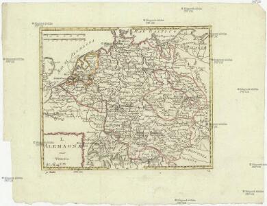
L Alemagna
1 : 7100000 Evropa střední Zatta, Antonio Zatta
Imperii Romano-Germanici
1 : 2400000 Mollova mapová sbírka Schatz, Johann Jakob Homann, Johann Baptista - dědici
Imperii Romano-Germanici
1 : 2400000 Mollova mapová sbírka Schatz, Johann Jakob Homann, Johann Baptista - dědici
Imperium Romano-Germanicum
1 : 2400000 Mollova mapová sbírka Homann, Johann Baptist Homann, Johann Baptista - dědici
Imperium Romano-Germanicum
1 : 2400000 Mollova mapová sbírka Homann, Johann Baptist Homann, Johann Baptista - dědici
Germania in Circulos Divisa
1 : 4300000 Mollova mapová sbírka Weigel, Christoph Weigel, Christoph I.
Hydrographia Germaniae
1 : 2400000 Mollova mapová sbírka Zollmann, Philipp Heinrich Homann, Johann Baptista - dědici
Hydrographica Germaniae Delineatio qua celebriorum Germaniae Fluvior Scaturigines, cursus et Ostia Oculis proponuntur
1 : 2500000 Mollova mapová sbírka Seutter, Matthäus Lotter, Tobias Conrad Seutter, Matthäus
Tabula Geographica Totius Germaniae
1 : 2400000 Homann, Johann Baptist
L'Empire d'Allemagne
1 : 1200000 Mollova mapová sbírka Sanson, Guillaume Covens, Johannes I
Homannův atlas světa
1 : 12500000
Accuratissima Germaniae tabula / denuo in lucem edita à Frederico de Wit
1 : 2400000 Annotatie: Origineel is Blad 62 in atlas factice Wit, Frederik de Amstelodami : [Fredericus de Wit]
Germania Seraphico-Observans seu Provinciae Fratrum Minorum strictioris Observantiae, in Germania sitae
1 : 2700000 Mollova mapová sbírka Seutter, Matthäus Seutter, Albrecht Carl Seutter, Matthäus

Empire d'Allemagne, divisé en ses dix cercles, ces cercles en leurs principaux estats
1 : 2810000 Evropa střední Sanson, Nicolas Cordier, Louis Pierre Mariette
Deutschland, Niederlande und Schweiz
Hand-Atlas über alle Theile der Erde nach dem neuesten Zustande und über das Weltgebäude Stieler, Adolf bei Justus Perthes
Besondere Post und Reise Carte der Wege Durch Teutschland
1 : 3600000 Mollova mapová sbírka
Tabula Geographica totius S[acri] Imperii Romani
1 : 1800000 Mollova mapová sbírka Müller, Johann Ulrich Bodenehr, Georg Conrad
Neueste Eisenbahn- und Kriegs-Karte
Evropa střední A.H. Payne
Germaniae = L’empire d’Allemagne distingué suivant l’étendue de tous les estats, principautés et souverainetés qui passent ou qui ont passé jusque a present sous le nom d’Allemagne
1 : 900000 sur les memoires les plus nouveaux de Mss. Sanson, de L'Isle Iaillot, de Fer, &c. A Amsterdam : par I. Cóvens et C. Mortier
Karte von Deutschland in XVI Blätt
1 : 1000000 nach des H.O.C. Büsching Erdbeschreibung u. den besten Hülfsmitteln entworffen und jetzt nach den neuesten Friedens-Schlüssen gänzlich umgeändert von D.F. Sotzmann J.W. Meil inv. ; C. Jäck sculp. Berlin : In Verlag der K. P. Ac. Kunst- und Buchhandlung von Simon Schropp & Co
Allemagne, distinguée en ses Cercles & subdivisée en ses Etats
1 : 2500000 Mollova mapová sbírka Schatz, Johann Jakob Homann, Johann Baptista - dědici
S[anctum] Imperium Romano-Germanicum oder Teutschland Mit Seinen Angräntzenden Königreichen Und Provincien
Reichelt, Julius; Visscher, Nicolaes; Hogeboom, Andries
Germaniae vulgo Duitschland, tabula comprehendens accuratam X. circulorum Bohemiae Regni ac Universae Helvetiae descriptionem cum divisione in caeteras partes
1 : 2250000 per Ian Bt. Elwe Amstelodami : Ian Bt. Elwe
(Teutschland, Pohlen, Ungarn, Turcken, Russland)
Hubner, Johann, 1688-1731
L'empiré d'Allemagne
1 : 1420000 Burgundsko (Francie) Jaillot, Alexis-Hubert Ottens, Josua Reinier & Iossua Ottens
Teutschland die Niederlande und die Schweiz
1 : 2860000 Nizozemsko Streit, Friedrich Wilhelm Boreux, J. J. C. Hinrichssche Buchhandlung