Maps of Germany

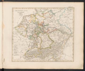
Deutschland, Niederlande und Schweiz
Hand-Atlas über alle Theile der Erde nach dem neuesten Zustande und über das Weltgebäude Stieler, Adolf bei Justus Perthes
Germania Seraphico-Observans seu Provinciae Fratrum Minorum strictioris Observantiae, in Germania sitae
1 : 2700000 Mollova mapová sbírka Seutter, Matthäus Seutter, Albrecht Carl Seutter, Matthäus
Deutschland Niederlande und Schweiz
Stieler's Hand-Atlas Stieler, Adolf bei Justus Perthes
Karte von Central-Europa bis Paris, Mailand, Triest, Pesth, Krakau, Köningsberg, Schleswig, zur Uebersicht der politischen Gestaltung im J. 1867, und der Eisenbahnen und andern Communicationen
1 : 1800000 Annotatie: Bijlage bij: Petermann's geographische Mittheilungen. Ergänzungsheft 19 Gotha : Justus Perthes
Karte von Deutschland in XVI Blätt
1 : 1000000 nach des H.O.C. Büsching Erdbeschreibung u. den besten Hülfsmitteln entworffen und jetzt nach den neuesten Friedens-Schlüssen gänzlich umgeändert von D.F. Sotzmann J.W. Meil inv. ; C. Jäck sculp. Berlin : In Verlag der K. P. Ac. Kunst- und Buchhandlung von Simon Schropp & Co
Nova totius Germaniae Descriptio Teütschland
1 : 4300000 Mollova mapová sbírka Merian, Matthaeus Merian, Matthäus
L'Empire d'Allemagne
1 : 1200000 Mollova mapová sbírka Sanson, Guillaume Covens, Johannes I
Peraccurata S. Romani Imperii Tabula, comprehendens Regiones vulgo sub Nomine Germaniae Nuncupantes
1 : 2100000 Mollova mapová sbírka Visscher, Nicolaes Jansz. Schenk, Peter II

Kharte von Deutschland nach der neuesten Eintheilung, zufolge der Bestimmung des Wiener Congresses und des Pariser Frieden von 1815 entworfen
1 : 2300000 Augsburg : bei Joh. Walch
Empire d'Allemagne, divisé en ses dix cercles, ces cercles en leurs principaux estats
1 : 2810000 Evropa střední Sanson, Nicolas Cordier, Louis Pierre Mariette
Neue Post-Karte von Teutschland zum altgemeinen Postbuch von Teutschland
1 : 2000000 Diez, Franz Maximilian 1761-1851 Berlin : C. Jack
(Teutschland, Pohlen, Ungarn, Turcken, Russland)
Hubner, Johann, 1688-1731
Mappa chorographica Omnivm Episcopatvvm Germaniae ab AC. MD ad MDCCLX existentium
1 : 2600000 Mollova mapová sbírka Hartzheim, Josephus Homann, Johann Baptista - dědici
Besondere Post und Reise Carte der Wege Durch Teutschland
1 : 3600000 Mollova mapová sbírka
Tabula Geographica totius S[acri] Imperii Romani
1 : 1800000 Mollova mapová sbírka Müller, Johann Ulrich Bodenehr, Georg Conrad
[Recto], uit: Post- und Eisenbahn-Karte von Deutschland, den Niederlanden, Belgien und der Schweiz / bearb. nach L. Friedrich's Post-, Eisenbahn- & Reisekarte von Mittel-Europa
1 : 1800000 Annotatie: Ondertitel op omslag: Bis Calais & Paris, Rügen & Königsberg, Krakau & Pesth, Venedig & Grenoble Gotha : Perthes
Deutschland und anliegende Länder, zur Übersicht der Eisenbahnen und Hauptstrassen
Hand-Atlas über alle Theile der Erde nach dem neuesten Zustande und über das Weltgebäude Stieler, Adolf bei Justus Perthes
Germania in Circulos Divisa
1 : 4300000 Mollova mapová sbírka Weigel, Christoph Weigel, Christoph I.
Societas Iesu Germana Sive Assistentia Germaniae
1 : 2600000 Mollova mapová sbírka Seutter, Matthäus Seutter, Georg Matthäus Seutter, Matthäus
Germaniae = L’empire d’Allemagne distingué suivant l’étendue de tous les estats, principautés et souverainetés qui passent ou qui ont passé jusque a present sous le nom d’Allemagne
1 : 900000 sur les memoires les plus nouveaux de Mss. Sanson, de L'Isle Iaillot, de Fer, &c. A Amsterdam : par I. Cóvens et C. Mortier
Regni Germaniae partium originariarum, ex quibus olim conslatum est facies hodierna ad Circulorum divisionem applicata
1 : 7900000 Mollova mapová sbírka Franz, Johann Michael Homann, Johann Baptista - dědici
Germania secundum observationes recentissimas in suos circulos divisa
1 : 2313000 Německo Walch, Johann Ioanes Walch
Germania secundum observationes recentissimas in suos circulos divisa
1 : 2313000 Německo Walch, Johann Ioanes Walch
Karte von Deutschland nach den Säkularisationen und Entschädigungen des Reichs - Deputations - Schlusses vom 20 November 1802
1 : 2370000 Evropa střední Walch, Johann bei Ioh. Walch
Eisen-Bahn-Atlas von Deutschland, Belgien, Elsass und dem nördlichsten Theile von Italien
Stülpnagel, Friedrich von ; Bär, J.C. Justus Perthes
Deutschland zu Anfang des dreissigjährigen Krieges, 1618
Evropa střední Goedsche & Steinmetz
Deutschland unter den sächsischen und fränkischen Kaisern bis 1138
Evropa střední Goedsche & Steinmetz
Deutschland im Jahre 1792
Evropa střední Goedsche & Steinmetz
Deutschland unter den Hohenstaufen
1 : 6000000 Evropa střední Goedsche & Steinmetz
Deutschland zur Zeit der Reformation
1 : 6000000 Evropa střední Goedsche & Steinmetz