Maps of Germany

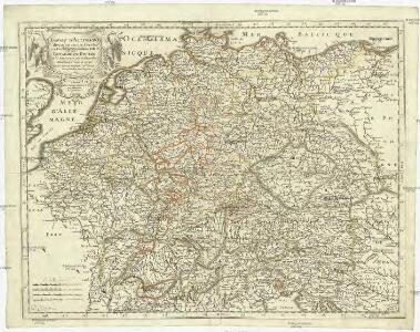
Empire d'Allemagne, divisé en ses dix cercles, ces cercles en leurs principaux estats
1 : 2810000 Evropa střední Sanson, Nicolas Cordier, Louis Pierre Mariette

Neu-vermehrte Post-Charte durch gantz Teutschland nach Italien, Franckreich, Niederland, Preußen, Polen und Ungarn &c.
1 : 2500000 Mollova mapová sbírka Nell, Johann Peter Homann, Johann Baptista
Karte von Teutschland
Německo Ritter, C.
Deutschland zu Anfang des dreissigjährigen Krieges, 1618
Evropa střední Goedsche & Steinmetz
Deutschland unter den sächsischen und fränkischen Kaisern bis 1138
Evropa střední Goedsche & Steinmetz
Deutschland im Jahre 1792
Evropa střední Goedsche & Steinmetz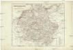
Deutschland unter den Hohenstaufen
1 : 6000000 Evropa střední Goedsche & Steinmetz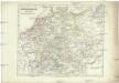
Deutschland zur Zeit der Reformation
1 : 6000000 Evropa střední Goedsche & Steinmetz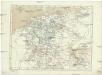
Deutschland im Jahre 1512
Evropa střední Goedsche & Steinmetz
Neue und vollstandige Postkarte durch ganz Deutschland
1 : 1480000 Německo Bors zu Overen, Johann Jakob Breidbach zu Bürresheim, Emmerich Joseph von bey dennen Homaennischen Erben
Karte von Deutschland in XVI Blätt
1 : 1000000 nach des H.O.C. Büsching Erdbeschreibung u. den besten Hülfsmitteln entworffen und jetzt nach den neuesten Friedens-Schlüssen gänzlich umgeändert von D.F. Sotzmann J.W. Meil inv. ; C. Jäck sculp. Berlin : In Verlag der K. P. Ac. Kunst- und Buchhandlung von Simon Schropp & Co
Deutschland von 1792 bis zur Gegenwart.
1 : 3800000 Spruner von Merz, Karl
Eisen-Bahn-Atlas von Deutschland, Belgien, Elsass und dem nördlichsten Theile von Italien
Stülpnagel, Friedrich von ; Bär, J.C. Justus Perthes
L'Empire d'Allemagne
1 : 1200000 Mollova mapová sbírka Sanson, Guillaume Covens, Johannes I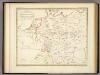
Ubersicht der Meteorologischen Stationen in Deutschland.
1 : 3700000 Berghaus, Heinrich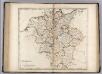
Germany.
1 : 2920000 Carey, Mathew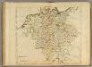
Germany.
1 : 2950000 Carey, Mathew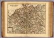
Carte exacte des postes et routes de l'Empire d'Allemagne divisee en ses cercles.
1 : 2500000 Covens et Mortier
Societas Iesu Germana Sive Assistentia Germaniae
1 : 2600000 Mollova mapová sbírka Seutter, Matthäus Seutter, Georg Matthäus Seutter, Matthäus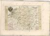

Karte von Central-Europa bis Paris, Mailand, Triest, Pesth, Krakau, Köningsberg, Schleswig, zur Uebersicht der politischen Gestaltung im J. 1867, und der Eisenbahnen und andern Communicationen
1 : 1800000 Annotatie: Bijlage bij: Petermann's geographische Mittheilungen. Ergänzungsheft 19 Gotha : Justus Perthes
(Teutschland, Pohlen, Ungarn, Turcken, Russland)
Hubner, Johann, 1688-1731
Charte von Deutschland

Germania Seraphico-Observans seu Provinciae Fratrum Minorum strictioris Observantiae, in Germania sitae
1 : 2700000 Mollova mapová sbírka Seutter, Matthäus Seutter, Albrecht Carl Seutter, Matthäus
Neu vermehrte Post Charte durch gantz Teutschland nach Italien Franckreich Niederland Preussen Polen und Ungarn etc
1 Karte : Kupferdruck ; 44 x 55 cm Nell von Nellenberg; Homann Homaennische Erben?
Neu-vermehrte Post-Charte durch gantz Teutschland nach Italien, Franckreich, Niederland, Preussen, Polen und Ungarn etc
1 Karte : Kupferdruck ; 45 x 57 cm Nell von Nellenberg; Homann Johann Baptist Homann
Historia Imperii Romano-Germanici, nec non finitimarum Regionum In Mappa exhibita, ac aeri incisa
1 : 2500000 Mollova mapová sbírka Seutter, Matthäus Seutter, Matthäus
Besondere Post und Reise Carte der Wege Durch Teutschland
1 : 3600000 Mollova mapová sbírka