Maps of Germany

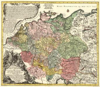
Germania Seraphico-Observans seu Provinciae Fratrum Minorum strictioris Observantiae, in Germania sitae
1 : 2700000 Mollova mapová sbírka Seutter, Matthäus Seutter, Albrecht Carl Seutter, Matthäus
Karte von Deutschland in XVI Blätt
1 : 1000000 nach des H.O.C. Büsching Erdbeschreibung u. den besten Hülfsmitteln entworffen und jetzt nach den neuesten Friedens-Schlüssen gänzlich umgeändert von D.F. Sotzmann J.W. Meil inv. ; C. Jäck sculp. Berlin : In Verlag der K. P. Ac. Kunst- und Buchhandlung von Simon Schropp & Co
L'Empire d'Allemagne
1 : 1200000 Mollova mapová sbírka Sanson, Guillaume Covens, Johannes I
Deutschland, Niederlande und Schweiz
Hand-Atlas über alle Theile der Erde nach dem neuesten Zustande und über das Weltgebäude Stieler, Adolf bei Justus Perthes
Karte von Central-Europa bis Paris, Mailand, Triest, Pesth, Krakau, Köningsberg, Schleswig, zur Uebersicht der politischen Gestaltung im J. 1867, und der Eisenbahnen und andern Communicationen
1 : 1800000 Annotatie: Bijlage bij: Petermann's geographische Mittheilungen. Ergänzungsheft 19 Gotha : Justus Perthes
Deutschland Niederlande und Schweiz
Stieler's Hand-Atlas Stieler, Adolf bei Justus Perthes
Empire d'Allemagne, divisé en ses dix cercles, ces cercles en leurs principaux estats
1 : 2810000 Evropa střední Sanson, Nicolas Cordier, Louis Pierre Mariette

Peraccurata S. Romani Imperii Tabula, comprehendens Regiones vulgo sub Nomine Germaniae Nuncupantes
1 : 2100000 Mollova mapová sbírka Visscher, Nicolaes Jansz. Schenk, Peter II
Nova totius Germaniae Descriptio Teütschland
1 : 4300000 Mollova mapová sbírka Merian, Matthaeus Merian, Matthäus
Deutschland zu Anfang des dreissigjährigen Krieges, 1618
Evropa střední Goedsche & Steinmetz
Deutschland unter den sächsischen und fränkischen Kaisern bis 1138
Evropa střední Goedsche & Steinmetz
Deutschland im Jahre 1792
Evropa střední Goedsche & Steinmetz
Deutschland unter den Hohenstaufen
1 : 6000000 Evropa střední Goedsche & Steinmetz
Deutschland zur Zeit der Reformation
1 : 6000000 Evropa střední Goedsche & Steinmetz
Deutschland im Jahre 1512
Evropa střední Goedsche & Steinmetz
(Teutschland, Pohlen, Ungarn, Turcken, Russland)
Hubner, Johann, 1688-1731
Kharte von Deutschland nach der neuesten Eintheilung, zufolge der Bestimmung des Wiener Congresses und des Pariser Frieden von 1815 entworfen
1 : 2300000 Augsburg : bei Joh. Walch
Societas Iesu Germana Sive Assistentia Germaniae
1 : 2600000 Mollova mapová sbírka Seutter, Matthäus Seutter, Georg Matthäus Seutter, Matthäus
[Recto], uit: Post- und Eisenbahn-Karte von Deutschland, den Niederlanden, Belgien und der Schweiz / bearb. nach L. Friedrich's Post-, Eisenbahn- & Reisekarte von Mittel-Europa
1 : 1800000 Annotatie: Ondertitel op omslag: Bis Calais & Paris, Rügen & Königsberg, Krakau & Pesth, Venedig & Grenoble Gotha : Perthes
Charte von Deutschland

Deutschland und anliegende Länder, zur Übersicht der Eisenbahnen und Hauptstrassen
Hand-Atlas über alle Theile der Erde nach dem neuesten Zustande und über das Weltgebäude Stieler, Adolf bei Justus Perthes
Ubersicht der Meteorologischen Stationen in Deutschland.
1 : 3700000 Berghaus, Heinrich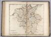
Germany.
1 : 2920000 Carey, Mathew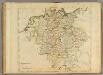
Germany.
1 : 2950000 Carey, Mathew
Deutschland von 1792 bis zur Gegenwart.
1 : 3800000 Spruner von Merz, Karl

Eisen-Bahn-Atlas von Deutschland, Belgien, Elsass und dem nördlichsten Theile von Italien
Stülpnagel, Friedrich von ; Bär, J.C. Justus Perthes
Karte von Teutschland
Německo Ritter, C.