Maps of Germany

Neue Postkarte von Deutschland und einem Theile Frankreichs
Německo in Verlage der Schrämblischen Buchdruckerey
Germaniae vulgo Duitschland, tabula comprehendens accuratam X. circulorum Bohemiae Regni ac Universae Helvetiae descriptionem cum divisione in caeteras partes
1 : 2250000 per Ian Bt. Elwe Amstelodami : Ian Bt. Elwe
Homannův atlas světa
1 : 12500000
L Alemagna
1 : 7100000 Evropa střední Zatta, Antonio Zatta
Charte welche das Deutsche Reich nach seinen Kreisen und Staaten vorstellet
1 : 2660000 Evropa střední Homann, Johann Baptist Schatz, Johann Jakob bey den Homaennischen Erben
Hydrographia Germaniae
1 : 2400000 Mollova mapová sbírka Zollmann, Philipp Heinrich Homann, Johann Baptista - dědici
Hydrographica Germaniae Delineatio qua celebriorum Germaniae Fluvior Scaturigines, cursus et Ostia Oculis proponuntur
1 : 2500000 Mollova mapová sbírka Seutter, Matthäus Lotter, Tobias Conrad Seutter, Matthäus
S[anctum] Imperium Romano-Germanicum oder Teutschland Mit Seinen Angräntzenden Königreichen Und Provincien
Reichelt, Julius; Visscher, Nicolaes; Hogeboom, Andries
Neu vermehrte Post Charte durch gantz Teutschland nach Italien, Franckreich, Niederland, Preußen, Polen, und Ungarn &c.

Germania secundum observationes recentissimas in suos circulos divisa
1 : 2313000 Německo Walch, Johann Ioanes Walch
Germania secundum observationes recentissimas in suos circulos divisa
1 : 2313000 Německo Walch, Johann Ioanes Walch
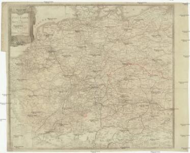
Neue Post-Karte von Teutschland zum altgemeinen Postbuch von Teutschland
1 : 2000000 Diez, Franz Maximilian 1761-1851 Berlin : C. Jack
Tabula Geographica Totius Germaniae
1 : 2400000 Homann, Johann Baptist
S. Imperium Romano-Germanicum oder Teutschland mit seinen Angräntzenden Königreichen und Provincien
1 : 2500000 Mollova mapová sbírka Visscher, Nicolaes Jansz. Hogeboom, Andries Schenk, Peter II
S. Imperium Romano-Germanicum oder Teutschland mit seinen Angräntzenden Königreichen und Provincien
1 : 2500000 Mollova mapová sbírka Schenk, Pieter Hogeboom, Andries Schenk, Peter II
S. Imperium Romano-Germanicum oder Teutschland mit seinen Angräntzenden Königreichen und Provincien
1 : 2500000 Mollova mapová sbírka Schenk, Pieter Hogeboom, Andries Schenk, Peter II

Imperii Romano-Germanici
1 : 2400000 Mollova mapová sbírka Schatz, Johann Jakob Homann, Johann Baptista - dědici
Imperii Romano-Germanici
1 : 2400000 Mollova mapová sbírka Schatz, Johann Jakob Homann, Johann Baptista - dědici
Imperium Romano-Germanicum
1 : 2400000 Mollova mapová sbírka Homann, Johann Baptist Homann, Johann Baptista - dědici
Imperium Romano-Germanicum
1 : 2400000 Mollova mapová sbírka Homann, Johann Baptist Homann, Johann Baptista - dědici
Imperium Romano-Germanicum in suos circulos electorat. et status accurate distinctum
1 : 2500000 Evropa střední Homann, Johann Baptist J. B. Homann
IMPERIUM ROMANO-GERMANICUM IN SUOS CIRCULOS DIVISUM Geographice exhibitum
1 : 2450000 Evropa střední Homann, Johann Baptist Hübner, Johann a Ioh. Baptista Homanno
Accuratissima Germaniae Tabula Denuo in lucem edita
1 : 2400000 Mollova mapová sbírka Wit, Frederik de Ottens, Josua
Accuratißima totius Germaniae Tabula Novissime in lucem edita
1 : 2400000 Mollova mapová sbírka Funck, David Homann, Johann Baptist Funck, David
Accuratissima Germaniae Tabula
1 : 2500000 Mollova mapová sbírka Danckerts, Justus Danckerts, Justus

[Historisch-geographischer Atlas zu den allgemeinen Geschichtswerken von C. v. Rotteck, Pölitz u. Becker] : Deutschland's frühere kirchliche Eintheilung
von J.V. Kutscheit Lithographie der Herderschen Verlags-Handlung zu Freiburg im Breisgau [Freiburg im Breisgau] : [Herder]