Maps of Maryland
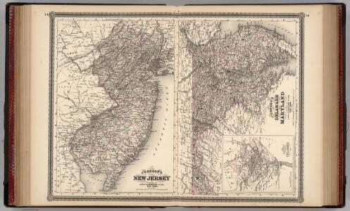
New Jersey, Delaware, and Maryland.
1 : 700000 Johnson, A.J.
New Jersey, Delaware, and Maryland.
1 : 700000 Johnson, A.J.
New Jersey, Delaware, and Maryland.
1 : 700000 Johnson, A.J.
County Map Of Pennsylvania, New Jersey, Maryland, And Delaware.
1 : 2050000 Mitchell, Samuel Augustus
Pa. Md. N.J. & Del.
1 : 1330560 Cram Atlas Company
Pennsylvania, New Jersey, Delaware.
1 : 1181000 Finley, Anthony
Schonberg's Map of Pennsylvania, New Jersey, Maryland and Delaware.
1 : 1900000 Schonberg & Co.
North America: sheet VII, Pennsylvania, New Jersey, Maryland, Delaware, Columbia and part of Virginia / published under the superintendence of the Society for the Diffusion of Useful Knowledge; J. & C. Walker, sculp.
from Parts C. Walker,
A survey of the Northern Neck of Virginia : being the lands belonging to the Rt. Honourable Thomas Lord Fairfax Baron Cameron, bounded by & within the Bay of Chesapoyocke and between the rivers Rappahannock and Potowmack: With the courses of the rive
from Cartographic materials from the Emmet Collection of Manuscripts Etc. Relating to American History.
Nova Virginiae Tabula [Karte], in: Novus atlas absolutissimus, Bd. 6, S. 207.
1 Karte aus Atlas Janssonius Offizin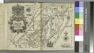
Delineatio Pennsilvaniae et Caesareae, nov. occident seu West N. Iersey in America / Jonas Silfvorling sculp. Up. 1731.
from Dissertatio gradualis, de plantatione ecclesiae svecanae in America : quam, suffragante ampl. senatu philosoph. in Regio Upsal. athenaeo, praeside, viro amplissimo atque celeberrimo mag. Andrea Bronwall ... in audit. Gust. maj. d. 14 jun. an. MDCCXXXI / examinandam modeste sistit Tobias E. Biörck, americano-dalekarlus.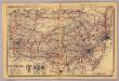
Pennsylvania.
1 : 1420000 Rand McNally and Company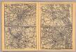
Philadelphia, Pittsburgh, Richmond, Baltimore-Washington.
Rand McNally and Company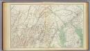
Gen. map I.
1 : 633600 United States. War Department
A map of the most inhabited part of Virginia containing the whole province of Maryland with part of Pensilvania, New Jersey and North Carolina / drawn by Joshua Fry & Peter Jefferson in 1751.
From Parts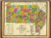
Map of Pennsylvania, New Jersey, and Delaware.
1 : 1160000 Mitchell, Samuel Augustus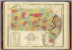
Map Of Pennsylvania New Jersey And Delaware.
1 : 1140000 Finley, Anthony
The tourist's pocket map of the state of Virginia: exhibiting its internal improvements, roads, distances, &c. / by J.H. Young; engraved by E. Yeager & F. Dankworth.
from Virginia J. H. Young; E. Yeager; F. Dankworth,
The tourist's pocket map of the state of Virginia: exhibiting its internal improvements, roads, distances, &c. / by J.H. Young; engraved by E. Yeager & F. Dankworth.
from Virginia J. H. Young; E. Yeager; F. Dankworth,
The travellers pocket map of Virginia: with its canals, rail-roads & distances from place to place along the stage roads / by H.S. Tanner; engraved by W. Brose, Philadelphia, 1830.
from Virginia Henry S. Tanner; W. Brose,
Map of Pennsylvania, New Jersey and Delaware compiled from the latest authorities.
from Parts Mitchell, S. Augustus (Samuel Augustus) -- Compiler,
The tourist's pocket map of Pennsylvania: exhibiting its internal improvements, roads, distances &c. / by J. H. Young; D. Haines, sc.
from Whole J. H. Young; D. Haines,
The tourist's pocket map of Pennsylvania: exhibiting its internal improvements, roads, distances &c. / by J. H. Young; D. Haines, sc.
from Whole J. H. Young; D. Haines,
The tourist's pocket map of Pennsylvania: exhibiting its internal improvements, roads, distances &c. / by J.H. Young; D. Haines sc.
from Whole J. H. Young; D. Haines,
A new mapp of East and West New Jarsey.
from The sea-atlas : containing an hydrographical description of most of the sea-coasts of the known parts of the world.
Nova Virginiae Tabula [Karte], in: Novus Atlas, das ist, Weltbeschreibung, Bd. 2, S. 325.
1 Karte aus Atlas Blaeu, Joan Blaeu, Willem Janszoon
Map of the states of Pennsylvania and New Jersey / engraved & printed by Fenner Sears & Co.
from Parts Fenner Sears & Co.,
Auto Trails Map. Pennsylvania, New Jersey, Southern New York, Northern Delaware, Northern Maryland, Northern Virginia, North East W. Virginia.
1 : 822000 Rand McNally and Company
Delaware and Maryland.
1 : 960000 Colton, G.W.