Maps of Maryland

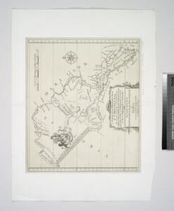
A survey of the Northern Neck of Virginia : being the lands belonging to the Rt. Honourable Thomas Lord Fairfax Baron Cameron, bounded by & within the Bay of Chesapoyocke and between the rivers Rappahannock and Potowmack: With the courses of the rive
from Cartographic materials from the Emmet Collection of Manuscripts Etc. Relating to American History.
Penn., N.J., Md., Dela., D.C., Virginia.
1 : 1770000 Society for the Diffusion of Useful Knowledge (Great Britain)
E. United States 7.
1 : 1774080 Letts, Son & Co.
Pennsylvania.
1 : 2724480 Scott, Joseph
Our Nation's Camp Ground.
1 : 2181787 Ensign, Bridgman & Fanning
Philadelphia, Pittsburgh, Richmond, Baltimore-Washington.
Rand McNally and Company
The tourist's pocket map of Pennsylvania : exhibiting its internal improvements, roads, distances &c. / by J.H. Young ; D. Haines, sc.
from Whole
Schonberg's Map of Pennsylvania, New Jersey, Maryland and Delaware.
1 : 1900000 Schonberg & Co.
A new map of Virginia : from the best authorities / by T. Kitchen, geogr.
from Virginia
County Map Of Pennsylvania, New Jersey, Maryland, And Delaware.
1 : 2050000 Mitchell, Samuel Augustus
Pa. Md. N.J. & Del.
1 : 1330560 Cram Atlas Company
Nova Virginiae Tabula [Karte], in: Novus atlas absolutissimus, Bd. 6, S. 207.
1 Karte aus Atlas Janssonius Offizin
Pennsylvania, New Jersey, Delaware.
1 : 1181000 Finley, Anthony
A New map of the province of Maryland in North America.
from Maryland
North America: sheet VII, Pennsylvania, New Jersey, Maryland, Delaware, Columbia and part of Virginia / published under the superintendence of the Society for the Diffusion of Useful Knowledge; J. & C. Walker, sculp.
from Parts C. Walker,
(Virginia, Maryland, Delaware)
1 : 4200000 Moore, M. B. (Marinda Branson), 1829-1864
Map of Virginia, Maryland and Delaware exhibiting the post offices, post roads, canals, rail roads &c. / by David H. Burr, (Late topographer to the Post Office,) Geographer to the House of Representatives of the U.S.
from Parts David H. Burr,
Operations in Virginia.
from Virginia
Neueste Karte von Maryland und Delaware mit seinen Canaelen, Strassen und Entfernungen der Hauptpunkte
Grosser Hand-Atlas über alle Theile der Erde in 170 Karten Meyer, J. Verlag des Bibliographischen Instituts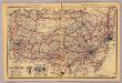
Pennsylvania.
1 : 1420000 Rand McNally and Company
The tourist's pocket map of the state of Virginia: exhibiting its internal improvements, roads, distances, &c. / by J.H. Young; engraved by E. Yeager & F. Dankworth.
from Virginia J. H. Young; E. Yeager; F. Dankworth,
The tourist's pocket map of the state of Virginia: exhibiting its internal improvements, roads, distances, &c. / by J.H. Young; engraved by E. Yeager & F. Dankworth.
from Virginia J. H. Young; E. Yeager; F. Dankworth,
The travellers pocket map of Virginia: with its canals, rail-roads & distances from place to place along the stage roads / by H.S. Tanner; engraved by W. Brose, Philadelphia, 1830.
from Virginia Henry S. Tanner; W. Brose,
Virginie, Pensylvanie.
1 : 2000000 Vincent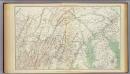
Gen. map I.
1 : 633600 United States. War Department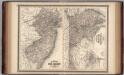
New Jersey, Delaware, and Maryland.
1 : 700000 Johnson, A.J.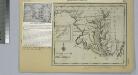
Maryland.
from Maryland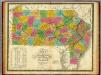
Map of Pennsylvania, New Jersey, and Delaware.
1 : 1160000 Mitchell, Samuel Augustus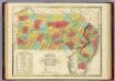
Map Of Pennsylvania New Jersey And Delaware.
1 : 1140000 Finley, Anthony