Maps of Pennsylvania

Map of Pennsylvania, New Jersey and Delaware compiled from the latest authorities.
from Parts Mitchell, S. Augustus (Samuel Augustus) -- Compiler,
Map of the states of Pennsylvania and New Jersey / engraved & printed by Fenner Sears & Co.
from Parts Fenner Sears & Co.,
A new mapp of East and West New Jarsey.
from The sea-atlas : containing an hydrographical description of most of the sea-coasts of the known parts of the world.
A map of Pennsylvania exhibiting not only the improved parts of that Province, but also its extensive frontiers : laid down from actual surveys and chiefly from the late map of W. Scull published in 1770 : and humbly inscribed to the Honourable Thomas Pe
from Whole
Pennsylvania.
1 : 2175000 Schonberg & Co.
A map of the canals & rail roads of Pennsylvania and New Jersey, and the adjoining states / by H.S. Tanner; engraved by H.S. Tanner & assistants.
from Parts Henry S. Tanner,
The tourist's pocket map of Pennsylvania: exhibiting its internal improvements, roads, distances &c. / by J. H. Young; D. Haines, sc.
from Whole J. H. Young; D. Haines,
The tourist's pocket map of Pennsylvania: exhibiting its internal improvements, roads, distances &c. / by J. H. Young; D. Haines, sc.
from Whole J. H. Young; D. Haines,
The tourist's pocket map of Pennsylvania: exhibiting its internal improvements, roads, distances &c. / by J.H. Young; D. Haines sc.
from Whole J. H. Young; D. Haines,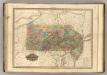
Pennsylvania and New Jersey.
1 : 1120000 Tanner, Henry S.
Pennsylvania / by David H. Burr; W. Harrison, sc.
from Whole David H. Burr; W. Harrison,
A New and accurate map of New Jersey : from the best authorities.
from Whole
Pennsylvania, New Jersey, Delaware.
1 : 1181000 Finley, Anthony
A map of the canals & rail roads of Pennsylvania and New Jersey, and the adjoining states / by H.S. Tanner; engraved by H.S. Tanner & assistants.
from Parts Henry S. Tanner,
A map of the canals & rail roads of Pennsylvania and New Jersey and the adjoining states / by H. S. Tanner; engraved by H.S. Tanner & assistants.
from Parts Henry S. Tanner,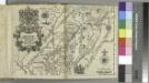
Delineatio Pennsilvaniae et Caesareae, nov. occident seu West N. Iersey in America / Jonas Silfvorling sculp. Up. 1731.
from Dissertatio gradualis, de plantatione ecclesiae svecanae in America : quam, suffragante ampl. senatu philosoph. in Regio Upsal. athenaeo, praeside, viro amplissimo atque celeberrimo mag. Andrea Bronwall ... in audit. Gust. maj. d. 14 jun. an. MDCCXXXI / examinandam modeste sistit Tobias E. Biörck, americano-dalekarlus.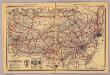
Pennsylvania.
1 : 1420000 Rand McNally and Company
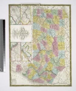
Schonberg's Map of Pennsylvania, New Jersey, Maryland and Delaware.
1 : 1900000 Schonberg & Co.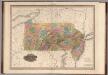
Pennsylvania and New Jersey.
1 : 1100000 Tanner, Henry S.
Map of Pennsylvania and New Jersey / by H.S. Tanner; engraved by H.S. Tanner & assistants.
from Parts Henry S. Tanner,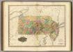
Map Of Pennsylvania And New Jersey.
1 : 1140480 Tanner, Henry S.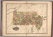
Pennsylvania and New Jersey.
1 : 1100000 Tanner, Henry S.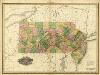
Pennsylvania and New Jersey.
1 : 1100000 Tanner, Henry S.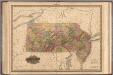
Pennsylvania and New Jersey.
1 : 1100000 Tanner, Henry S.
Pennsylvania and New Jersey.
1 : 1280000 Asher & Adams
Pa. Md. N.J. & Del.
1 : 1330560 Cram Atlas Company
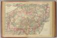
County Map Of Pennsylvania, New Jersey, Maryland, And Delaware.
1 : 2050000 Mitchell, Samuel Augustus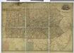
Map of Pennsylvania / constructed from the county surveys authorized by the state, and other original documents ; revised and improved under the supervision of Wm. E. Morris, civil engineer, upon data procured in each county ; engraved by Edwd. Yeager.
from Whole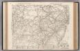
Auto Trails Map. Pennsylvania, New Jersey, Southern New York, Northern Delaware, Northern Maryland, Northern Virginia, North East W. Virginia.
1 : 822000 Rand McNally and Company