Maps of Maryland
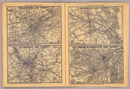
Philadelphia, Pittsburgh, Richmond, Baltimore-Washington.
Rand McNally and Company
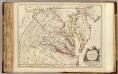
A New map of the province of Maryland in North America.
from Maryland
E. United States 7.
1 : 1774080 Letts, Son & Co.
Our Nation's Camp Ground.
1 : 2181787 Ensign, Bridgman & Fanning
A survey of the Northern Neck of Virginia : being the lands belonging to the Rt. Honourable Thomas Lord Fairfax Baron Cameron, bounded by & within the Bay of Chesapoyocke and between the rivers Rappahannock and Potowmack: With the courses of the rive
from Cartographic materials from the Emmet Collection of Manuscripts Etc. Relating to American History.
(Virginia, Maryland, Delaware)
1 : 4200000 Moore, M. B. (Marinda Branson), 1829-1864
Penn., N.J., Md., Dela., D.C., Virginia.
1 : 1770000 Society for the Diffusion of Useful Knowledge (Great Britain)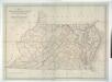
Map of Virginia, Maryland and Delaware exhibiting the post offices, post roads, canals, rail roads &c. / by David H. Burr, (Late topographer to the Post Office,) Geographer to the House of Representatives of the U.S.
from Parts David H. Burr,
A map of that part of America where a degree of latitude was measured for the Royal Society / by Cha. Mason & Jere. Dixon.
from Charts and maps
The tourist's pocket map of the state of Virginia: exhibiting its internal improvements, roads, distances, &c. / by J.H. Young; engraved by E. Yeager & F. Dankworth.
from Virginia J. H. Young; E. Yeager; F. Dankworth,
The tourist's pocket map of the state of Virginia: exhibiting its internal improvements, roads, distances, &c. / by J.H. Young; engraved by E. Yeager & F. Dankworth.
from Virginia J. H. Young; E. Yeager; F. Dankworth,
The travellers pocket map of Virginia: with its canals, rail-roads & distances from place to place along the stage roads / by H.S. Tanner; engraved by W. Brose, Philadelphia, 1830.
from Virginia Henry S. Tanner; W. Brose,
Neueste Karte von Maryland und Delaware mit seinen Canaelen, Strassen und Entfernungen der Hauptpunkte
Grosser Hand-Atlas über alle Theile der Erde in 170 Karten Meyer, J. Verlag des Bibliographischen Instituts
Operations in Virginia.
from Virginia
Nova Virginiae Tabula [Karte], in: Novus atlas absolutissimus, Bd. 6, S. 207.
1 Karte aus Atlas Janssonius Offizin
Maryland.
from Maryland
A map of the most inhabited part of Virginia containing the whole province of Maryland with part of Pensilvania, New Jersey and North Carolina / drawn by Joshua Fry & Peter Jefferson in 1775.
from Charts and maps
A new map of Maryland and Delaware : with their canals, roads & distances / by H.S. Tanner ; E. Gillingham, sc.
from Parts
Virginie, Pensylvanie.
1 : 2000000 Vincent
A map of Maryland with the Delaware counties and the southern part of New Jersey &c. / by T. Kitchin, geogr.
from Charts and maps Thomas Kitchin,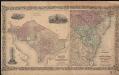
Colton's Georgetown and the city of Washington : the capital of the United States of America ; Colton's map showing part of Virginia, Maryland, Pennsylvania, New Jersey & New York
1 : 525000 Colton, J. H. Colton, J. H.
Schonberg's Map of Pennsylvania, New Jersey, Maryland and Delaware.
1 : 1900000 Schonberg & Co.
A map of Virginia: formed from actual surveys and the latest as well as the most accurate observations / by James Madison; drawn by Wm. Davis; with extensive additions and corrections to the year 1818.
from Charts and maps James Madison; William Davis,
A map of Virginia: formed from actual surveys and the latest as well as the most accurate observations / by James Madison; drawn by Wm. Davis; with extensive additions and corrections to the year 1818.
from Charts and maps James Madison; William Davis,
A map of Virginia: formed from actual surveys, and the latest as well as most accurate observations / by James Madison, D.D., president of Wm. & Mary College.; drawn by Wm. Davis; engraved by Fred. Bossler, Richmd.
from Charts and maps James Madison; William Davis; Fred. Bossler,
Nova Virginiae Tabula [Karte], in: Novus Atlas, das ist, Weltbeschreibung, Bd. 2, S. 325.
1 Karte aus Atlas Blaeu, Joan Blaeu, Willem Janszoon
North America: sheet VII, Pennsylvania, New Jersey, Maryland, Delaware, Columbia and part of Virginia / published under the superintendence of the Society for the Diffusion of Useful Knowledge; J. & C. Walker, sculp.
from Parts C. Walker,
Pennsylvania, New Jersey, Delaware.
1 : 1181000 Finley, Anthony
Pocket Map, showing the probable Theatre of the War. Compiled by G.A. Aschbach
Pocket Map, showing the probable Theatre of the War. Compiled by G.A. Aschbach. Published in Philadelphia, Pocket Map Showing the Probable Theatre of the War, complied by G.A. Aschbach, details the states of Virginia, Maryland and Pennsylvania. Published in 1860, before any major fighting had occurred, this map highlights areas that would see the bulk of fighting in the conflict. The map shows the balance on military power on either side by pointing out camps and forts. The Union held military bases are underlined in red, while Confederate holdings are in blue. The map also shows railway lines running across the states.