Maps of Maryland

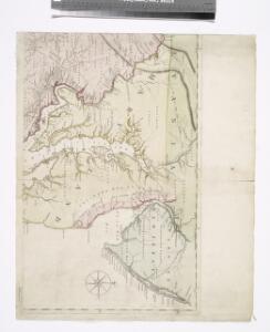
A map of the most inhabited part of Virginia containing the whole province of Maryland with part of Pensilvania, New Jersey and North Carolina / drawn by Joshua Fry & Peter Jefferson in 1751.
From Parts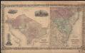
Colton's Georgetown and the city of Washington : the capital of the United States of America ; Colton's map showing part of Virginia, Maryland, Pennsylvania, New Jersey & New York
1 : 525000 Colton, J. H. Colton, J. H.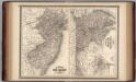
New Jersey, Delaware, and Maryland.
1 : 700000 Johnson, A.J.
An exact map of New Jersey, Pensylvania, New York, Maryland & Virginia, from the latest surveys / J. Lodge, sculp.
from Parts John Lodge,
Map of the state of Maryland : laid down from an actual survey of all the principal waters, public roads, and divisions of the counties therein : describing the situation of the cities, towns, villages, houses of worship and other public buildings, fu...
From Maryland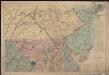
Bacon's topographical war map showing the battle fields of Pennsylvania, Maryland, and Virginia
1 : 540000 G.W. Bacon & Co. G.W. Bacon & Co.
Maryland.
from Carey's general atlas, improved and enlarged : being a collection of maps of the world and quarters, their principal empires, kingdoms, &c.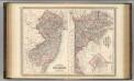
New Jersey, Delaware, and Maryland.
1 : 700000 Johnson, A.J.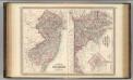
New Jersey, Delaware, and Maryland.
1 : 700000 Johnson, A.J.
Index to the Plates in Christopher Colles' Survey of the Roads.
1 : 2027520 Ristow, W. editor
A chart of Delaware Bay and River : containing a full and exact description of the shores, creeks, harbours, soundings, shoals, sands, and bearings of the most considerable land marks &c. &c. / faithfully coppied [sic] from that published at Philadelphia
from Parts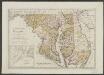
Maryland und Delaware
1 : 500000 Sotzmann, D. F Bey Carl Ernst Bohn
Nova Virginae Tabula [Karte], in: Theatrum orbis terrarum, sive, Atlas novus, Bd. 2, S. 327.
1 Karte aus Atlas Blaeu, Joan Blaeu, Willem Janszoon

Neueste Karte von Maryland und Delaware mit seinen Canaelen, Strassen und Entfernungen der Hauptpunkte
Grosser Hand-Atlas über alle Theile der Erde in 170 Karten Meyer, J. Verlag des Bibliographischen Instituts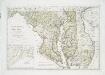
Maryland und Delaware / entworfen von D.F. Sotzmann ; W. Sander, sculp.
from Charts and maps
Delaware and Maryland.
1 : 960000 Colton, G.W.
Delaware and Mary-Land / By David H. Burr, New-York; engd. & printed by Illman & Pilbrow.
from Parts David H. Burr; Illman & Pilbrow,
Delaware and Maryland. Baltimore.
1 : 958000 Gray, Ormando Willis
NOVA VIRGINIÆ TABVLA
DGrijp Sculpt [Amsterdam : Joan Blaeu]
A new map of Maryland and Delaware : with their canals, roads & distances / by H.S. Tanner ; E. Gillingham, sc.
from Parts
Routes between New-York & Washington / drawn by I. Smith, geographer.
from Parts
D'Engelze volkplanting in Virginie / door Iohan Smith bezogt en verder uytgeset; uytgevoerd te Leyden door Pieter vander Aa.
from Charts and maps Pieter vander Aa,
Maryland and Delaware.
1 : 1130000 Mitchell, Samuel Augustus
Maryland and Delaware.
1 : 1130000 Mitchell, Samuel Augustus
A map of New Jersey, from the best authorities.
from The American geography; or, A view of the present situation of the United States of America: containing astronomical geography; geographical definitions, discovery, and general description ... By Jedidiah Morse, A.M.
Delaware and Maryland.
1 : 1000000 Colton, G.W.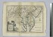
A map of Maryland with the Delaware counties and the southern part of New Jersey &c. / by T. Kitchin, geogr.
from Charts and maps Thomas Kitchin,
Map Of The Seat Of War.
1 : 633600 Monk, Jacob