Maps of Maryland

Nova Virginiae Tabula [Karte], in: Novus Atlas, das ist, Weltbeschreibung, Bd. 2, S. 325.
1 Karte aus Atlas Blaeu, Joan Blaeu, Willem Janszoon
The tourist's pocket map of the state of Virginia: exhibiting its internal improvements, roads, distances, &c. / by J.H. Young; engraved by E. Yeager & F. Dankworth.
from Virginia J. H. Young; E. Yeager; F. Dankworth,
The tourist's pocket map of the state of Virginia: exhibiting its internal improvements, roads, distances, &c. / by J.H. Young; engraved by E. Yeager & F. Dankworth.
from Virginia J. H. Young; E. Yeager; F. Dankworth,
The travellers pocket map of Virginia: with its canals, rail-roads & distances from place to place along the stage roads / by H.S. Tanner; engraved by W. Brose, Philadelphia, 1830.
from Virginia Henry S. Tanner; W. Brose,
Nova Virginiae Tabula [Karte], in: Novus atlas absolutissimus, Bd. 6, S. 207.
1 Karte aus Atlas Janssonius Offizin
Nova Virginiae Tabula [Karte], in: Le théâtre du monde, ou, Nouvel atlas contenant les chartes et descriptions de tous les païs de la terre, Bd. 2, S. 318.
1 Karte aus Atlas Blaeu, Willem Janszoon und Blaeu, Joan Blaeu, Willem Janszoon
A map of that part of America where a degree of latitude was measured for the Royal Society / by Cha. Mason & Jere. Dixon.
from Charts and maps
A New map of Virginia.; The history of the British plantations in America. With a chronological account of the most remarkable things, which happen'd to the first adventurers in their several discoveries of that new world. Part I. Containing The history of Virginia; with remarks on the trade and commerce of that colony ...
from The history of the British plantations in America. With a chronological account of the most remarkable things, which happen'd to the first adventurers in their several discoveries of that new world. Part I. Containing The history of Virginia; with remarks on the trade and commerce of that colony ... Keith, William, Sir; Society for the Encouragement of Learning,
A New map of Virginia.
from Cartographic materials from the Emmet Collection of Manuscripts Etc. Relating to American History. Printed at the expense of the Society for the Encouragement of Learning, by S. Richardson: [London],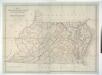
Map of Virginia, Maryland and Delaware exhibiting the post offices, post roads, canals, rail roads &c. / by David H. Burr, (Late topographer to the Post Office,) Geographer to the House of Representatives of the U.S.
from Parts David H. Burr,
(Virginia, Maryland, Delaware)
1 : 4200000 Moore, M. B. (Marinda Branson), 1829-1864
North America: sheet VII, Pennsylvania, New Jersey, Maryland, Delaware, Columbia and part of Virginia / published under the superintendence of the Society for the Diffusion of Useful Knowledge; J. & C. Walker, sculp.
from Parts C. Walker,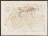
Nova Virginiae Tabula [Karte], in: Gerardi Mercatoris et I. Hondii Newer Atlas, oder, Grosses Weltbuch, Bd. 2, S. 392.
1 Karte aus Atlas Mercator, Gerhard und Hondius, Jodocus Jansson, Jan
Operations in Virginia.
from Virginia
Nova Virginae Tabula [Karte], in: Theatrum orbis terrarum, sive, Atlas novus, Bd. 2, S. 327.
1 Karte aus Atlas Blaeu, Joan Blaeu, Willem Janszoon
Penn., N.J., Md., Dela., D.C., Virginia.
1 : 1770000 Society for the Diffusion of Useful Knowledge (Great Britain)
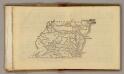
Shell Highway Map of Delaware - Maryland, Virginia, W. Virginia. (western portion).
1 : 950400 Shell Oil Company
A new and accurate map of the province of Virginia in North America.
from Virginia
Map of Virginia, Maryland and Delaware / I. Mutlow sc. 6 James St. Covt. Gardn.
from Charts and maps
A map of the most inhabited part of Virginia containing the whole province of Maryland with part of Pensilvania, New Jersey and North Carolina / drawn by Joshua Fry & Peter Jefferson in 1775.
from Charts and maps
Map Of The Seat Of War.
1 : 633600 Monk, Jacob
A New map of the province of Maryland in North America.
from Maryland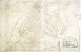
A map of the most inhabited part of Virginia: containing the whole province of Maryland with part of Pensilvania, New Jersey and North Carolina / drawn by Joshua Fry & Peter Jefferson in 1775.
from Charts and maps Joshua Fry & Peter Jefferson,
Carte de la Virginie et du Maryland dressée sur la grande carte angloise de Mrs. Josué Fry et Pierre Jefferson, / par le Sr. Robert de Vaugondy, géographe; Groux.
from John H. Levine Collection Robert de Vaugondy; Mrs. Josué Fry et Pierre Jefferson,
NOVA VIRGINIÆ TABVLA
DGrijp Sculpt [Amsterdam : Joan Blaeu]
A new map of Maryland and Delaware : with their canals, roads & distances / by H.S. Tanner ; E. Gillingham, sc.
from Parts
Virginia
1 : 1300000 Smith, John [Merianische Erben]
Neueste Karte von Maryland und Delaware mit seinen Canaelen, Strassen und Entfernungen der Hauptpunkte
Grosser Hand-Atlas über alle Theile der Erde in 170 Karten Meyer, J. Verlag des Bibliographischen Instituts
Map of Virginia and Maryland, constructed from the latest authorities / J.H. Young sc.
from Parts J. H. Young,
Virginia, Maryland and Delaware.
from Parts s.n.: [Philadelphia?],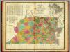
Map of Virginia and Maryland.
1 : 1450000 Mitchell, Samuel Augustus
Map of Virginia and Maryland, constructed from the latest authorities.
from Parts Published by Anthony Finley, at the corner of Chestnut and Fourth Streets?: [Philadelphia?],
![Nova Virginiae Tabula [Karte], in: Novus Atlas, das ist, Weltbeschreibung, Bd. 2, S. 325.](https://images-2.georeferencer.com/images/iiif/264306761184/full/,300/0/native.jpg)

