Maps of Maryland

A New map of Virginia.; The history of the British plantations in America. With a chronological account of the most remarkable things, which happen'd to the first adventurers in their several discoveries of that new world. Part I. Containing The history of Virginia; with remarks on the trade and commerce of that colony ...
from The history of the British plantations in America. With a chronological account of the most remarkable things, which happen'd to the first adventurers in their several discoveries of that new world. Part I. Containing The history of Virginia; with remarks on the trade and commerce of that colony ... Keith, William, Sir; Society for the Encouragement of Learning,
A New map of Virginia.
from Cartographic materials from the Emmet Collection of Manuscripts Etc. Relating to American History. Printed at the expense of the Society for the Encouragement of Learning, by S. Richardson: [London],
Map of Virginia, Maryland and Delaware / I. Mutlow sc. 6 James St. Covt. Gardn.
from Charts and maps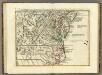
Il Maryland, il Jersey Meridionale, la Delaware.
1 : 2100000 Zatta, Antonio
Shell Sectional Map No. 3 - Middle Atlantic States.
1 : 1457280 Shell Oil Company
A new map of Virginia from the best authorities / by T. Kitchin, Geogr.
from London magazine, or, Gentleman's monthly intelligencer (1747)
The tourist's pocket map of the state of Virginia: exhibiting its internal improvements, roads, distances, &c. / by J.H. Young; engraved by E. Yeager & F. Dankworth.
from Virginia J. H. Young; E. Yeager; F. Dankworth,
The tourist's pocket map of the state of Virginia: exhibiting its internal improvements, roads, distances, &c. / by J.H. Young; engraved by E. Yeager & F. Dankworth.
from Virginia J. H. Young; E. Yeager; F. Dankworth,
The travellers pocket map of Virginia: with its canals, rail-roads & distances from place to place along the stage roads / by H.S. Tanner; engraved by W. Brose, Philadelphia, 1830.
from Virginia Henry S. Tanner; W. Brose,
A new map of Virginia : from the best authorities / by T. Kitchen, geogr.
from Virginia
Il Maryland, il Jersey Meridionale, la Delaware e la parte Orientale della Virginia, e Carolina Settentrionale.
from Charts and maps A. (Antonio) Zatta:[Venezia],
A new and accurate map of the province of Virginia in North America.
from Virginia
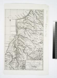
A map of that part of America where a degree of latitude was measured for the Royal Society / by Cha. Mason & Jere. Dixon.
from Charts and maps
Nova Virginiae Tabula [Karte], in: Novus atlas absolutissimus, Bd. 6, S. 207.
1 Karte aus Atlas Janssonius Offizin
Nova Virginiae Tabula [Karte], in: Novus Atlas, das ist, Weltbeschreibung, Bd. 2, S. 325.
1 Karte aus Atlas Blaeu, Joan Blaeu, Willem Janszoon
Operations in Virginia.
from Virginia
(Virginia, N. Carolina) Railroad Map of the United States.
1 : 506880 Rand McNally and Company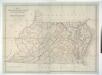
Map of Virginia, Maryland and Delaware exhibiting the post offices, post roads, canals, rail roads &c. / by David H. Burr, (Late topographer to the Post Office,) Geographer to the House of Representatives of the U.S.
from Parts David H. Burr,
(Virginia, Maryland, Delaware)
1 : 4200000 Moore, M. B. (Marinda Branson), 1829-1864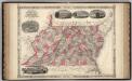
Virginia, Delaware, Maryland, and West Virginia.
1 : 1487000 Johnson, A.J.
Lord Balitmore's own plan : proposed Maryland/Pennsylvania boundary.
from Maryland
Penn., N.J., Md., Dela., D.C., Virginia.
1 : 1770000 Society for the Diffusion of Useful Knowledge (Great Britain)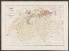
Nova Virginiae Tabula [Karte], in: Gerardi Mercatoris et I. Hondii Newer Atlas, oder, Grosses Weltbuch, Bd. 2, S. 392.
1 Karte aus Atlas Mercator, Gerhard und Hondius, Jodocus Jansson, Jan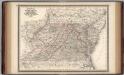
Virginia, Delaware, Maryland, and West Virginia.
1 : 1520000 Johnson, A.J.
A map of the most inhabited part of Virginia containing the whole province of Maryland with part of Pensilvania, New Jersey and North Carolina / drawn by Joshua Fry & Peter Jefferson in 1775.
from Charts and maps
E. United States 7.
1 : 1774080 Letts, Son & Co.
North America: sheet VII, Pennsylvania, New Jersey, Maryland, Delaware, Columbia and part of Virginia / published under the superintendence of the Society for the Diffusion of Useful Knowledge; J. & C. Walker, sculp.
from Parts C. Walker,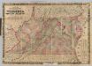
Virginia, Maryland, Delaware.
1 : 760320 Colton, J. H.
D'Engelze volkplanting in Virginie / door Iohan Smith bezogt en verder uytgeset ; uytgevoerd te Leyden door Pieter vander Aa.
from De Gedenkwaardige Reizen vanden beroemden Capiteyn Johan Smith na Virginien : gedaan in den Jare 1606. en vervolgens ; waar in een nauwkeurige beschrijving dier Plaatsen, desselfs Inwoonders, hunne Godsdienst, Zeden, Gewoontens, manieren van Regeering, Planten, Vrugten, enz. omstandig vertoond werd, mitsgaders des Schrijvers wonderlijke gevallen met de Wilden, en verdere zeldzame ontmoetingen ; nu aldereerst uit het Engels vertaald, met nodige Konst-printen en Register voorzien.