Maps of Maryland

Maps of Maryland

$title$

Nova Virginiae Tabula [Karte], in: Le théâtre du monde, ou, Nouvel atlas contenant les chartes et descriptions de tous les païs de la terre, Bd. 2, S. 318.
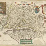
1 Karte aus Atlas Blaeu, Willem Janszoon und Blaeu, Joan Blaeu, Willem Janszoon
$title$

Nova Virginiae Tabula [Karte], in: Novus Atlas, das ist, Weltbeschreibung, Bd. 2, S. 325.

1 Karte aus Atlas Blaeu, Joan Blaeu, Willem Janszoon
$title$

$title$

Nova Virginiae Tabula [Karte], in: Gerardi Mercatoris et I. Hondii Newer Atlas, oder, Grosses Weltbuch, Bd. 2, S. 392.

1 Karte aus Atlas Mercator, Gerhard und Hondius, Jodocus Jansson, Jan
$title$

Nova Virginae Tabula [Karte], in: Theatrum orbis terrarum, sive, Atlas novus, Bd. 2, S. 327.

1 Karte aus Atlas Blaeu, Joan Blaeu, Willem Janszoon
$title$

The tourist's pocket map of the state of Virginia: exhibiting its internal improvements, roads, distances, &c. / by J.H. Young; engraved by E. Yeager & F. Dankworth.

from Virginia J. H. Young; E. Yeager; F. Dankworth,
$title$

The tourist's pocket map of the state of Virginia: exhibiting its internal improvements, roads, distances, &c. / by J.H. Young; engraved by E. Yeager & F. Dankworth.

from Virginia J. H. Young; E. Yeager; F. Dankworth,
$title$

The travellers pocket map of Virginia: with its canals, rail-roads & distances from place to place along the stage roads / by H.S. Tanner; engraved by W. Brose, Philadelphia, 1830.

from Virginia Henry S. Tanner; W. Brose,
$title$

Nova Virginiae Tabula [Karte], in: Novus atlas absolutissimus, Bd. 6, S. 207.

1 Karte aus Atlas Janssonius Offizin
$title$

A map of that part of America where a degree of latitude was measured for the Royal Society / by Cha. Mason & Jere. Dixon.

from Charts and maps
$title$

Operations in Virginia.

from Virginia
$title$

(Virginia, Maryland, Delaware)

1 : 4200000 Moore, M. B. (Marinda Branson), 1829-1864
$title$

North America: sheet VII, Pennsylvania, New Jersey, Maryland, Delaware, Columbia and part of Virginia / published under the superintendence of the Society for the Diffusion of Useful Knowledge; J. & C. Walker, sculp.

from Parts C. Walker,
$title$

Map Of The Seat Of War.

1 : 633600 Monk, Jacob
$title$

Shell Highway Map of Delaware - Maryland, Virginia, W. Virginia. (western portion).

1 : 950400 Shell Oil Company
$title$

NOVA VIRGINIÆ TABVLA

DGrijp Sculpt [Amsterdam : Joan Blaeu]
$title$

Penn., N.J., Md., Dela., D.C., Virginia.

1 : 1770000 Society for the Diffusion of Useful Knowledge (Great Britain)
$title$

A new and accurate map of the province of Virginia in North America.

from Virginia
$title$

Virginia

1 : 1300000 Smith, John [Merianische Erben]
$title$

A new map of Maryland and Delaware : with their canals, roads & distances / by H.S. Tanner ; E. Gillingham, sc.

from Parts
$title$

The new war map of Virginia, Maryland & Pennsylvania

1 : 510000 Russel, B.B. (Benjamin B.)
$title$

Neueste Karte von Maryland und Delaware mit seinen Canaelen, Strassen und Entfernungen der Hauptpunkte

Grosser Hand-Atlas über alle Theile der Erde in 170 Karten Meyer, J. Verlag des Bibliographischen Instituts
$title$

A map of Virginia: formed from actual surveys and the latest as well as the most accurate observations / by James Madison; drawn by Wm. Davis; with extensive additions and corrections to the year 1818.

from Charts and maps James Madison; William Davis,
$title$

A map of Virginia: formed from actual surveys and the latest as well as the most accurate observations / by James Madison; drawn by Wm. Davis; with extensive additions and corrections to the year 1818.

from Charts and maps James Madison; William Davis,
$title$

A map of Virginia: formed from actual surveys, and the latest as well as most accurate observations / by James Madison, D.D., president of Wm. & Mary College.; drawn by Wm. Davis; engraved by Fred. Bossler, Richmd.

from Charts and maps James Madison; William Davis; Fred. Bossler,
$title$

Carte de la Virginie et du Maryland dressée sur la grande carte angloise de Mrs. Josué Fry et Pierre Jefferson, / par le Sr. Robert de Vaugondy, géographe; Groux.

from John H. Levine Collection Robert de Vaugondy; Mrs. Josué Fry et Pierre Jefferson,
$title$

Maryland.

from Carey's general atlas, improved and enlarged : being a collection of maps of the world and quarters, their principal empires, kingdoms, &c.
$title$

Strategic war points of the United States

$title$

Strategic War Points of the United States no.3: the country round the Chesapeake and the Potomac to Washington

Strategic War points of the United States no.3: the country round the Chesapeake and the Potomac to Washington J. Wyld
$title$

Philadelphia, Pittsburgh, Richmond, Baltimore-Washington.

Rand McNally and Company
© MapTiler © OpenStreetMap contributors
How does it work?
These instructions will show you how to find historical maps online.
Getting started
Type the place name in the search box to find the exact location. You can further adjust the search by zooming in and out.
Zoom
Zoom in and out with the buttons or use your mouse or touchpad natively.
Exact Area tool
Click here and draw a rectangle over the map to precisely define the search area.
Set filters
Narrow your search with advanced settings, such as Years (from/to), Fulltext, Publisher, etc.
Results
See the results of your search on the right side. You can scroll down to find more maps of this location.
?

Download OldMapsOnline Mobile