Maps of Seven Seas (Open Ocean)

The Bermudas, or Summer's Islands.
1 : 60000 Jefferys, Thomas
The Bermudas, or Summer's Islands
1 : 60000
A Map of the British Empire in America. (Sheet 11).
1 : 2000000 Popple, Henry
Mappa æstivarum insularum alias Bermudas dictarum ad ostia Mexicani ... accurate descr. = A Mapp of the Sommer Islands once called the Bermudas lying at the mouth of the Bay of Mexico ... exactlie surveyed
1 : 70000
Mappa aestivarum insularum, alias Barmudas dictarum, ad ostia Mexicani aestuarij jacentium in latitudine graduum 32 minutorum 25 : Ab Anglia, Londino Scilicet versus Libonotum 3300 miliaribus Anglicanis, et a Roanoack (qui locus est in Virginia) ...
1 : 50700
Mappa aestivarum insularum alias Barmudas dictarum, ad Ostia Mexicani aestuarij jacentium in latitudine graduum 32 minutorum 25. Ab Anglia Londino scilicet versus Libonotum 3300 Miliaribus Anglicanis, et a Roanoack (qui locus est in Virginia) versus ...
1 : 3400000
Dominia anglorum in praecipius insulis Americae ut sunt S. Christophori, Antego, Iamaica, Barbados nec non insulae Bermudos vel Sommer dictae
Antigua (Antigua a Barbuda) Homannianos Heredes
West Indies 1.
1 : 2900000 Arrowsmith, Aaron
[Recto], uit: Reading railroad system and connections
Buffalo, N.Y. : The Matthews-Northrup Co.
A Map of the British and French settlements in North America: (part the second) containing part of New York, Pensilvania, New Jersey, Mary Land, Virginia, North & South Carolina, Georgia, Louisiana, and all the countries westward in the same parellels so far as discovered, shewing the course of the Rivers Ohio, Missisipi &c. exhibiting the just boundaries & the French encroachments laid down from authentic surveys / T. Bowen, sc.
from Parts T. Bowen,
Mitchell's Reference & Distance Map Of The United States.
1 : 1584000 Young, James H.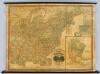
United States.
1 : 1964160 Woodbridge, J.L.
Mitchell's National Map of the United States.
1 : 3360000 Mitchell, Samuel Augustus
United States of America

Mitchell's Reference & Distance Map Of The United States.
1 : 1584000 Young, James H.
Map of the United States of America.; Carey's general atlas, improved and enlarged: being a collection of maps of the world and quarters, their principal empires, kingdoms, &c.
from Carey's general atlas, improved and enlarged : being a collection of maps of the world and quarters, their principal empires, kingdoms, &c. Carey, Mathew; Manning, Thomas S.,
Mitchell's Reference & Distance Map of the United States.
1 : 1584000 Young, James H.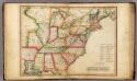
United States.
1 : 7603200 Melish, John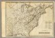
United States.
1 : 7603200 Melish, John
Map of the United States.
1 : 1900800 Varle, Charles P.
Die Vereinigten Staaten von Nordamerika
1 Karte : Kupferdruck ; 52 x 64 cm Lewis; Arrowsmith in der Schneider- und Weigelschen K.K. privilegirten Kunsthandlung
The United States of America confirmed by treaty 1783

United States.
from Whole s.n.: [London?],
Mitchell's Reference & Distance Map Of The United States.
1 : 1584000 Young, James H.
United States of America.
1 : 5300000 Scott, Bradford
Mitchell's Reference & Distance Map Of The United States.
1 : 1584000 Young, James H.
United States.
1 : 9800000 Cummings, J. A. (Jacob Abbot)
United States - eastern section.
1 : 5000000 John Bartholomew & Co.
Nova Anglia Novum Belgium et Virginia [Karte], in: Gerardi Mercatoris et I. Hondii Newer Atlas, oder, Grosses Weltbuch, Bd. 2, S. 386.
1 Karte aus Atlas Mercator, Gerhard und Hondius, Jodocus Jansson, Jan


