Maps of Appalachian Mountains

Nova Anglia Novum Belgium et Virginia [Karte], in: Gerardi Mercatoris et I. Hondii Newer Atlas, oder, Grosses Weltbuch, Bd. 2, S. 386.
1 Karte aus Atlas Mercator, Gerhard und Hondius, Jodocus Jansson, Jan
West-Indien, Central-Amerika bis zum südlichen Canada in 4 Blättern
1 : 7500000 Nordost-Blatt Petermann, August Heinrich ; Habenicht, H. Justus Perthes
Map of the United States in North America: with the British, French and Spanish dominions adjoining, according to the Treaty of 1783 / by Thos. Kitchin, Senr., hydrographer to his Majesty.
from Charts and maps Thomas Kitchin, Sr.,
Die Atlantischen Staaten zwischen Washington & Boston, Blatt 2]
Adolf Stieler's Handatlas über alle Theile der Erde und über das Weltgebäude Stieler, Adolf Justus Perthes
Mappa geographica Americae Septentrionalis: ad emendatiora exemplaria adhuc edita jussu Acad. reg. scient. et eleg. litt. descripta. pars. II.
from Parts Michaelis: [Berolini]; Euler, Leonhard,
America Septentrionalis
1 : 1300000 Kanada západní Anville, Jean-Baptiste Bourguinon d' Homannianorum heredum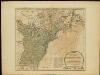
The United States of America with the British possessions of Canada, Nova Scotia, & of Newfoundland, divided with the French ...

Composite: Canada, Louisiane, Terres Angloises.
1 : 2900000 Anville, Jean Baptiste Bourguignon d, 1697-1782
Die Colonien der Engländer in Nord-America vor und im Revolutions-Krieg
1 : 10000000 von Joh. Val. Kutscheit Freiburg im Breisgau : [Herder]

North America from the French of Mr. D'Anville: improved with the back settlements of Virginia and course of Ohio: illustrated with geographical and historical remarks.
from Charts and maps D'Anville,
AMERICA SEPTENTRIONALIS
1 : 6300000 Ohio, řeka-oblast Anville, Jean-Baptiste Bourguinon d' sumptibus ab Homannianorum Heredum
America Septentrionalis
1 : 6500000 Spojené státy americké-oblast východní Anville, Jean-Baptiste Bourguinon d' ab Homanniorum Heredum
AMERICA SEPTENTRIONALIS
1 : 7000000 Ohio, řeka-oblast Anville, Jean-Baptiste Bourguinon d' sumptibus ab Homannianorum Heredum
A new and accurate map of the English empire in North America: representing their rightful claim as confirm'd by charters and the formal surrender of their Indian friends, likewise the encroachments of the French, with the several forts they have unjustly erected therein / by a Society of Anti-Gallicans.
from Charts and maps Society of Anti-Gallicans.,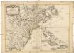
Carte des possessions angloises dans l'Amerique Septentrionale
1 : 3500000 Spojené státy americké-oblast východní Imbert, J. Leopold chez Mondhare
A new map of North America from the latest discoveries, 1763.
from Charts and maps s.n.: [London],
America Septentrionalis a Domino d'Anville in Galliis edita nunc in Anglia: Coloniis in interiorem Virginiam deductis nec non Fluvii Ohio cursu aucta notisque geographicis et historicis illustrata / Sumptibus Homannianorum Heredum.
from Charts and maps Sumptibus Homannianorum Heredum,
Carte generale des colonies angloises dans l'Amerique Septentrionale pour l'intelligence de la guerre presente / d'apres des manuscrit anglais par J. B. Nolin geographe; corrigé, augmenté des indications des principaux évenemens de la guerre avec le tracee des limites pour constituer le traité de paix proposé entre la Couronne de la Grande Bretagne et les Etats Unis, par R. Phelipeau, géographe ... 1783.
from Revolutionary War, 1775-1783 J. B. Nolin; R. Phelipeau,
Die vereinigten Staaten von Nord-America: nach der von Wm. Faden 1783 herausgegebenen Charte, auf welcher alle im englisch americanischen Kriege vorzüglich merkwürdig gewordenen Örter angezeigt, auch die Grenzen zwischen Grosbrittanien, America und Spanien nach Maasgabe des Friedensschulusses von 1783 bestimmt sind / T. Marianus, Sculp., A.V.; Geschichte der Revolution von Nord-America.
from Geschichte der Revolution von Nord-America. Gegel, Ludwig Bernhard Friederich; Sprengel, M. C. (Matthias Christian),
Theatrum belli in America Septentrionali: II. foliis comprehensum / jussu Acad[emiis] Reg[iis] Scient[iarum] et Eleg[antium] Litt[erarum] exhibet; I.C. Rhode Ac[ademiae?] Geogr[aphus?]; Berger, sculpsit Berol[ini].
from Parts Berol[ini].,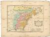
Carte des possessions angloises & françoises du continent de l'Amérique septentrionale
1 : 8500000 Severní Amerika Gosse, Pierre
A new map of part of the United States of North America : containing those of New York, Vermont, New Hampshire, Massachusets, Connecticut, Rhode Island, Pennsylvania, New Jersey, Delaware, Maryland and Virginia from the latest authorities / by John Cary,
from Parts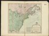
The United States of America with the British possessions of Canada, Nova Scotia, New Brunswick and Newfoundland divided with the French, also the Spanish territories of Louisiana and Florida according to the preliminary articles of peace signed at Versailles the 20th of Jany. 1783

Theztre de la guerre en Amerique

An accurate map of the English colonies in North America bordering on the River Ohio.
from Parts

Carte du theatre de la guerre présente en Amerique
1 : 5000000 Nová Anglie Denis, L. Basset, André Basset
Carte nouvelle de l'Amerique Angloise
1 : 4400000 Spojené státy americké-oblast východní Lotter, Matthäus Albrecht par Matthieu Albert Lotter
![Nova Anglia Novum Belgium et Virginia [Karte], in: Gerardi Mercatoris et I. Hondii Newer Atlas, oder, Grosses Weltbuch, Bd. 2, S. 386.](https://images-2.georeferencer.com/images/iiif/302436410552/full/,300/0/native.jpg)

