Maps of Central Lowland

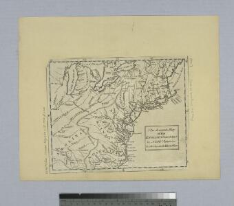
An accurate map of the English colonies in North America bordering on the River Ohio.
from Parts
Die vereinigten Staaten von Nord-America: nach der von Wm. Faden 1783 herausgegebenen Charte, auf welcher alle im englisch americanischen Kriege vorzüglich merkwürdig gewordenen Örter angezeigt, auch die Grenzen zwischen Grosbrittanien, America und Spanien nach Maasgabe des Friedensschulusses von 1783 bestimmt sind / T. Marianus, Sculp., A.V.; Geschichte der Revolution von Nord-America.
from Geschichte der Revolution von Nord-America. Gegel, Ludwig Bernhard Friederich; Sprengel, M. C. (Matthias Christian),
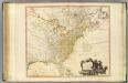
A map of the British and French dominions in North America, with the roads, distances, limits, and extent of the settlements, humbly inscribed to the Right Honourable the Earl of Halifax, and the other Right Honourable the Lords Commissioners for Trade & Plantations / by their Lordships most obliged and very humble servant, Jno. Mitchell; Tho. Kitchin, sculp.
from Parts John Mitchell; Thomas Kitchin,
Map of the British and French Dominions in North America.
1 : 2000000 Mitchell, John
Etats-Unis de l'Amerique en 1855.
1 : 8300000 Garnier, F. A., 1803-1863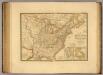
Etats-Unis, Haut et Bas-Canada, Nouvle. Ecosse, Nouvau. Brunswick, Terre-Neuve.
1 : 7000000 Picquet, C.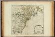
North America from the French of Mr. D'Anville.
1 : 6350000 Jefferys, Thomas
Part of North America : comprehending the course of the Ohio, New England, New York, New Jersey, Pensilvania, Maryland, Virginia ...
from English pilot. The fourth book.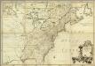
Amerique Septentrionale.
1 : 2000000 Mitchell, John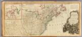
North America (north)
1 : 5400000 Robert Laurie & James Whittle
Carte generale des treize Etats Unis, de l'Amerique septentrionale

The United States of America, showing the boundaries fixed in 1782, five years before the ratification of the Constitution : from a contemporary copy of Benjamin Franklin's red-line map identified in Spain by the Library of Congress at Washington.
1 : 6860480 Facsimile of map published in Paris by Le Rouge and dated 1777. Relief shown pictorially. Inset letters of Aranda and Franklin printed in facsimile reflect the official use of the map in establishing United States boundaries. "Reprinted 1838 by U.S. Geological Survey." Includes text and inset: Nouvelle carte de la Baye dHudson et de Labrador selon las dernieres cartes levées sur les lieux. "This map is one of a series of similar colored maps, depicting the 13 original states from New Hampshire to Georgia at the time of the formation of the Constitution." John, Mitchel, 1711-1768 Washington, D.C. : United States Constitution Sesquicentennial Commission, [Washington, D.C.] : U.S. Geological Survey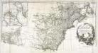
Amérique septentrionale, 2
2 Blätter : mehrfarbig ; 52 x 113 cm chez l'auteur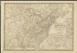
Nouvelle carte des États-Unis, du Haut et Bas-Canada, de la Nouvelle-Écosse, du Nouvau-Brunswick, de Terre-Neuve, etc.
1 : 4000000 dressée par A. H. Brué, géographe du Roi Paris : chez l'auteur
U.S., Canada.
1 : 15600000 Huntington, Nathaniel G. (Nathaniel Gilbert), 1785-1848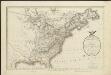
A map of the United States and Canada, New-Scotland, New-Brunswick and New-Foundland = Carte des Etats-Unis, avec le Canada, la Nouvelle Ecosse, le Nouveau Brunswick & Terre-Neuve
1 : 6500000 dressée par Lapie gravé par P. A. F. Tardieu ; écrit par J. J. Pachoux Paris [etc.] : P.A.F. Tardieu [etc.]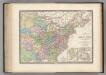
Region Orientale des Etats-Unis, Canada.
1 : 7000000 Levasseur, E.
A map of the United States : compiled chiefly from the state maps and other authentic information / by Saml. Lewis, 1809 ; W. [Harrison?] Junr., sculpt.
from Carey's American atlas.
A New & accurate map of North America: including the British acquisitions gain'd by the late war, 1763.
from Parts [Printed fr Edward and Charles Dilly, in the Poultry, and John Millan, at Charing-Cross]: [London],
Die Neuenglandstaaten bis 1783
1 : 16000000 Berlin : Mittler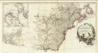
Amerique Septentrionale. (Northern section).
1 : 6300000 Anville, Jean Baptiste Bourguignon d, 1697-1782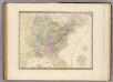
Etats-Unis d'Amerique.
1 : 8000000 Andriveau-Goujon, J.
Die Vereinigten Staaten von Nord-Amerika
Allgemeiner Atlas [Walch, Johannes] im Verlag bei Johannes Walch
The United States of North America, with the British & Spanish territories according to the treaty / engrav'd by Wm. Faden.
from Whole William Faden,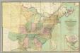
Map of the United States.
1 : 2000000 Walker, John & Alexander
A new and correct map of North America: in which the places of the principal engagements during the present war are accurately inserted / Jno. Lodge sculpt.
from Parts John Lodge,
A Map of the British and French settlements in North America.
from Parts J. (John) Hinton, Newgate Street: [London],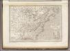
Etats Unis et Canada.
1 : 8400000 Montemont, A.
United States
A new general atlas of modern geography, consisting of a complete collection of maps of the four quarters of the globe Wyld, James James Wyld