Maps of Appalachian Mountains

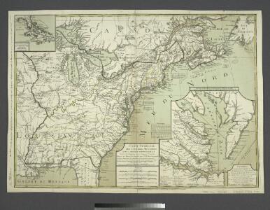
Carte generale des colonies angloises dans l'Amerique Septentrionale pour l'intelligence de la guerre presente / d'apres des manuscrit anglais par J. B. Nolin geographe; corrigé, augmenté des indications des principaux évenemens de la guerre avec le tracee des limites pour constituer le traité de paix proposé entre la Couronne de la Grande Bretagne et les Etats Unis, par R. Phelipeau, géographe ... 1783.
from Revolutionary War, 1775-1783 J. B. Nolin; R. Phelipeau,
America Septentrionalis
1 : 1300000 Kanada západní Anville, Jean-Baptiste Bourguinon d' Homannianorum heredum
Carte des possessions angloises & françoises du continent de l'Amérique septentrionale
1 : 8500000 Severní Amerika Gosse, Pierre
North America from the French of Mr. D'Anville: improved with the back settlements of Virginia and course of Ohio: illustrated with geographical and historical remarks.
from Charts and maps D'Anville,
The United States of America with the British possessions of Canada, Nova Scotia, & of Newfoundland, divided with the French ...

AMERICA SEPTENTRIONALIS
1 : 6300000 Ohio, řeka-oblast Anville, Jean-Baptiste Bourguinon d' sumptibus ab Homannianorum Heredum
America Septentrionalis
1 : 6500000 Spojené státy americké-oblast východní Anville, Jean-Baptiste Bourguinon d' ab Homanniorum Heredum
AMERICA SEPTENTRIONALIS
1 : 7000000 Ohio, řeka-oblast Anville, Jean-Baptiste Bourguinon d' sumptibus ab Homannianorum Heredum
A new and accurate map of the English empire in North America: representing their rightful claim as confirm'd by charters and the formal surrender of their Indian friends, likewise the encroachments of the French, with the several forts they have unjustly erected therein / by a Society of Anti-Gallicans.
from Charts and maps Society of Anti-Gallicans.,
America Septentrionalis a Domino d'Anville in Galliis edita nunc in Anglia: Coloniis in interiorem Virginiam deductis nec non Fluvii Ohio cursu aucta notisque geographicis et historicis illustrata / Sumptibus Homannianorum Heredum.
from Charts and maps Sumptibus Homannianorum Heredum,
Theztre de la guerre en Amerique
Carte des possessions angloises dans l'Amerique Septentrionale
1 : 3500000 Spojené státy americké-oblast východní Imbert, J. Leopold chez Mondhare
A new map of the English empire in America: viz. Virginia, Maryland, Carolina, New York, New Iarsey, New England, Pennsylvania, Newfoundland, New France &c. / revis'd by Ion. Senex, 1719; I. Harris, sculp.
from John H. Levine Collection John Senex; I. Harris,
A new map of the English empire in America: viz. Virginia, Maryland, Carolina, New York, New Iarsey, New England, Pennsylvania, Newfoundland, New France &c. / revis'd by Ion. Senex, 1719; I. Harris, sculp.
from Charts and maps John Senex; I. Harris,
A new map of North America from the latest discoveries, 1763.
from Charts and maps s.n.: [London],
Canada et Louisiane
Kanada Le Rouge, Georges-Louis le Rouge
Composite: Canada, Louisiane, Terres Angloises.
1 : 2900000 Anville, Jean Baptiste Bourguignon d, 1697-1782
The United States of America with the British possessions of Canada, Nova Scotia, New Brunswick and Newfoundland divided with the French, also the Spanish territories of Louisiana and Florida according to the preliminary articles of peace signed at Versailles the 20th of Jany. 1783

A new and correct map of North America: in which the places of the principal engagements during the present war are accurately inserted / Jno. Lodge sculpt.
from Parts John Lodge,
A Map of the British and French settlements in North America.
from Parts J. (John) Hinton, Newgate Street: [London],
Die Vereinigten Staaten von Nord-Amerika
Allgemeiner Atlas [Walch, Johannes] im Verlag bei Johannes Walch
Carte de l'Amérique septentrionale, depuis la baye d'Hudson jusqu'au Mississipi: pour servir aux essais historiques et politiques sur la révolution de cette partie du monde.; Essais historiques et politiques sur les Anglo-Américains, par M. Hilliard d'Auberteuil ...
from Essais historiques et politiques sur les Anglo-Américains, par M. Hilliard d'Auberteuil ... Hilliard d'Auberteuil, Michel René,
North America.
1 : 6500000 Jefferys, Thomas
Map of the United States in North America: with the British, French and Spanish dominions adjoining, according to the Treaty of 1783 / by Thos. Kitchin, Senr., hydrographer to his Majesty.
from Charts and maps Thomas Kitchin, Sr.,
Carte des Possessions Angloises & Françoises du Continent de l'Amerique Septentrionale
1 : 6900000 Mollova mapová sbírka Gosse, Pierre
West-Indien, Central-Amerika bis zum südlichen Canada in 4 Blättern
1 : 7500000 Nordost-Blatt Petermann, August Heinrich ; Habenicht, H. Justus Perthes
Die Atlantischen Staaten zwischen Washington & Boston, Blatt 2]
Adolf Stieler's Handatlas über alle Theile der Erde und über das Weltgebäude Stieler, Adolf Justus Perthes
Composite: Colonie Unite dell' America Settentrle.
1 : 2100000 Zatta, Antonio
Map of the British and French Dominions in North America.
1 : 2000000 Mitchell, John