Maps of Appalachian Mountains

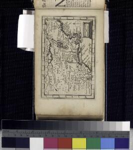
Newengland and New York.
from An epitome of Mr. John Speed's Theatre of the empire of Great Britain, and of his Prospect of the most famous parts of the world : in this new edition are added, the descriptions of His Majesties dominions abroad, viz. New England, New York, ... Carolina, Florida, ... Virginia, Maryland, ... Jamaica, Barbados, ... as also the empire of the Great Mogol, with the rest of the East Indies, ... the empire of Russia, with their respective descriptions.

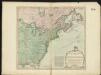
Carte nouvelle de l'Amerique Angloise
1 : 4400000 Spojené státy americké-oblast východní Lotter, Matthäus Albrecht par Matthieu Albert Lotter
Carte nouvelle de l'Amerique angloise contenant tout ce que les Anglois possedent sur le continent de l'Amerique Septentrionale
1 : 3800000 Spojené státy americké-oblast východní Lotter, Matthäus Albrecht Matthieu Albert Lotter
Carte nouvelle de l'Amerique angloise : contenant tout ce que les Anglois possedent sur le continent de l'Amerique septentrionale voir le Canada, la Nouvelle Ecosse ou Acadie, les treize provinces unies qui sont: les quatres colonies de la Nouvelle Angle
from Charts and maps
A new and exact map of the dominions of the King of Great Britain on ye continent of North America: containing Newfoundland, New Scotland, New England, New York, New Jersey, Pensilvania, Maryland, Virginia and Carolina / according to the newest and most exact observations by Herman Moll, geographer.
from John H. Levine Collection Herman Moll,
Canada et Louisiane
Kanada Le Rouge, Georges-Louis le Rouge
The United States of America with the British possessions of Canada, Nova Scotia, New Brunswick and Newfoundland divided with the French, also the Spanish territories of Louisiana and Florida according to the preliminary articles of peace signed at Versailles the 20th of Jany. 1783

Carte du theatre de la guerre présente en Amerique
1 : 5000000 Nová Anglie Denis, L. Basset, André Basset
[Recto], uit: Reading railroad system and connections
Buffalo, N.Y. : The Matthews-Northrup Co.
Canada et Louisiane
1 : 5000000 par le Sr. Le Rouge A Paris : [Le Rouge], Rue des Augustins]
Part of North America : comprehending the course of the Ohio, New England, New York, New Jersey, Pensilvania, Maryland, Virginia ...
from English pilot. The fourth book.
Die Colonien der Engländer in Nord-America vor und im Revolutions-Krieg
1 : 10000000 von Joh. Val. Kutscheit Freiburg im Breisgau : [Herder]
Composite: Colonie Unite dell' America Settentrle.
1 : 2100000 Zatta, Antonio
Mappa geographica Americae Septentrionalis: ad emendatiora exemplaria adhuc edita jussu Acad. reg. scient. et eleg. litt. descripta. pars. II.
from Parts Michaelis: [Berolini]; Euler, Leonhard,
Map of the United States in North America: with the British, French and Spanish dominions adjoining, according to the Treaty of 1783 / by Thos. Kitchin, Senr., hydrographer to his Majesty.
from Charts and maps Thomas Kitchin, Sr.,
Theztre de la guerre en Amerique

Carte nouvelle de l'Amerique angloise contenant tout ce que les Anglois possedent sur le continent de l'Amerique septentrionale savoir le Canada, la Nouvelle Ecosse ou Acadie, les treize Provinces unies qui sont: 1. New Hampshire, 2. Massachusetsbaye, 3. Rhode-Island, & 4. Conecticut, 5. la Nouvelle York, 6. Nouvelle Jersey, 7. Pensilvanie, 8. les Comtés de Newcastle, Kent et Sussex sur la Delaware, 9. Mariland, 10. Virginie, 11. la Caroline Septentrionale, 12. la Caroline Meridionale et 13. Georgie avec la Floride
1 : 5500000 gravée exactement d'après les determinations geographiques dernierement faites par Matthieu Albert Lotter Augsbourg : [Matthäus Albrecht Lotter]
North America from the French of Mr. D'Anville: improved with the back settlements of Virginia and course of Ohio: illustrated with geographical and historical remarks.
from Charts and maps D'Anville,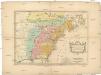
Carte des possessions angloises & françoises du continent de l'Amérique septentrionale
1 : 8500000 Severní Amerika Gosse, Pierre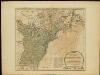
The United States of America with the British possessions of Canada, Nova Scotia, & of Newfoundland, divided with the French ...

Partie de l'Amérique septentrionale, qui comprend le cours de l'Ohio, la Nlle. Angleterre, la Nlle York, le New Jersey, la Pensylvanie, le Maryland, la Virginie, la Caroline / par le Sr. Robert de Vaugondy, géographe ordinaire du roi ; M. C. Haussard, fe
from Charts and maps
Composite: Canada, Louisiane, Terres Angloises.
1 : 2900000 Anville, Jean Baptiste Bourguignon d, 1697-1782
Carte de l'Amérique septentrionale, depuis la baye d'Hudson jusqu'au Mississipi: pour servir aux essais historiques et politiques sur la révolution de cette partie du monde.; Essais historiques et politiques sur les Anglo-Américains, par M. Hilliard d'Auberteuil ...
from Essais historiques et politiques sur les Anglo-Américains, par M. Hilliard d'Auberteuil ... Hilliard d'Auberteuil, Michel René,
Die Atlantischen Staaten zwischen Washington & Boston, Blatt 2]
Adolf Stieler's Handatlas über alle Theile der Erde und über das Weltgebäude Stieler, Adolf Justus Perthes
Carte generale des colonies angloises dans l'Amerique Septentrionale pour l'intelligence de la guerre presente / d'apres des manuscrit anglais par J. B. Nolin geographe; corrigé, augmenté des indications des principaux évenemens de la guerre avec le tracee des limites pour constituer le traité de paix proposé entre la Couronne de la Grande Bretagne et les Etats Unis, par R. Phelipeau, géographe ... 1783.
from Revolutionary War, 1775-1783 J. B. Nolin; R. Phelipeau,
West-Indien, Central-Amerika bis zum südlichen Canada in 4 Blättern
1 : 7500000 Nordost-Blatt Petermann, August Heinrich ; Habenicht, H. Justus Perthes