Maps of Allegheny Plat.

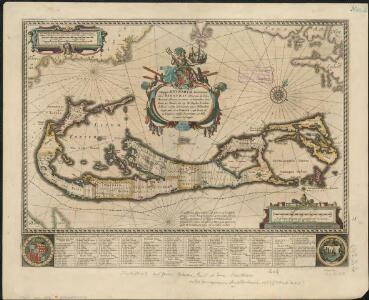
Mappa aestivarum insularum, alias Barmudas dictarum, ad ostia Mexicani aestuarij jacentium in latitudine graduum 32 minutorum 25 : Ab Anglia, Londino Scilicet versus Libonotum 3300 miliaribus Anglicanis, et a Roanoack (qui locus est in Virginia) ...
1 : 50700
Mappa aestivarum insularum alias Barmudas dictarum, ad Ostia Mexicani aestuarij jacentium in latitudine graduum 32 minutorum 25. Ab Anglia Londino scilicet versus Libonotum 3300 Miliaribus Anglicanis, et a Roanoack (qui locus est in Virginia) versus ...
1 : 3400000
Mappa æstivarum insularum alias Bermudas dictarum ad ostia Mexicani ... accurate descr. = A Mapp of the Sommer Islands once called the Bermudas lying at the mouth of the Bay of Mexico ... exactlie surveyed
1 : 70000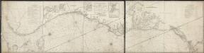
A new and accurate chart (from Captain Holland's surveys) of the North American coast, for the navigation between Cape Cod in New England, and the Havanna in the Gulf of Florida
1 : 765000 Laurie & Whittle Laurie & Whittle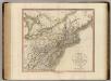
New York, Vermont, New Hampshire, etc.
1 : 2800000 Cary, John, ca. 1754-1835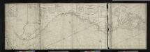
A new and accurate chart (from Captain Holland's surveys) of the North American Coast, for the navigation between Cape Cod in New England and the Havanna in the Gulf of Florida / respectfully inscribed to His Excellency Thomas Jefferson, president of the
from Charts and maps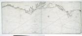
To the independent mariners of America: this chart of their coast from Savannah to Boston is most respectfully dedicated / by their much obliged & grateful servant, W. Heather; engraved by J. Stephenson.
from Charts and maps J. Stephenson; W. Heather,
Les États Unis de l'Amérique septentrionale
1 : 6050000 Spojené státy americké-oblast východní Bonne, Rigobert André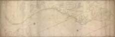
A new and accurate chart (from Captain Holland's surveys) of the North American Coast, for the navigation between Philadelphia and Florida respectfully inscribed to His Excellency Thomas Jefferson, president of the United States of North America / by his most obedient humble servants, Rob[er]t Laurie and Ja[me]s Whittle.
from Charts and maps Robert Laurie; James Whittle,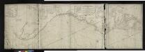
A new and accurate chart (from Captain Holland's surveys) of the North American Coast, for the navigation between Philadelphia and the Missisipi.
from Parts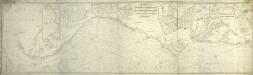
A chart of the coast of America: from New York and Philadelphia to the Strait or Gulf of Florida, and from thence to the Mississippi / a new edition corrected & improved by J.W. Norie, hydrographer, &c., 1837.
from Charts and maps J. W. Norie,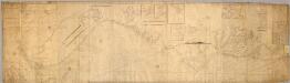
Chart, extending from 40|15' N. , 72|15' W. to 22|35" N., 80|25' W.
1 : 950000 Hooker, William
To the members of the Nautical Institution and Ship-masters' Society of the city of New York, this chart, extending from lat. 40o 15' N., long. 72o 15' W., to lat. 22o 35' N., long. 80o 25' W., is respectfully dedicated / by their obedient servant Edmund M. Blunt; plans engraved by Hooker, N. York.
from Charts and maps Hooker, William; Edmund M. Blunt,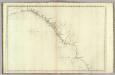
The coast of the United States from New York to St. Augustine (4th sheet)
1 : 900000 Blunt, Edmund M. (Edmund March), 1770-1862
Nova Belgica Et Anglia Nova [Karte], in: Novus atlas absolutissimus, Bd. 6, S. 202.
1 Karte aus Atlas Janssonius Offizin
Virginia, Marylandia et Carolina in America septentrionali Britannorum industria excultae / repraesentatae à Ioh. Bapt. Homann, S.C.M. Geog.
from Parts
Virginia and Maryland.
from An epitome of Mr. John Speed's Theatre of the empire of Great Britain, and of his Prospect of the most famous parts of the world : in this new edition are added, the descriptions of His Majesties dominions abroad, viz. New England, New York, ... Carolina, Florida, ... Virginia, Maryland, ... Jamaica, Barbados, ... as also the empire of the Great Mogol, with the rest of the East Indies, ... the empire of Russia, with their respective descriptions.
Pas caerte van Nieu Nederlandt en de Engelsche Virginies van Cabo Cod tot Cabo Canrick.
from De zee-atlas, ofte, Water-weereld : waer in vertoont werden alle de zee-kusten van het bekende des aerd-bodems : seer dienstigh voor alle heeren en kooplieden, als oock voor alle schippers en stuurlieden / gesneden, gedruckt en uytgegeven t'Amsteldam.
D'Engelze volkplanting in Virginie / door Iohan Smith bezogt en verder uytgeset = Peuplade des Anglois dans la Virginie / visitée et augmentée par Jean Smith, suivant qu il l'a décrite lui-même dans son voyage ; rectifiée sur de nouvelles observations fa
from Virginia
A chart of the coast of New York, New Jersey, Pensilvania, Maryland, Virginia, North Carolina, & c.
from Charts and maps
A map of Virginia and Maryland.
from Parts
A map of the travels of George Washington
1 : 2500000 Boston (Massachusetts : oblast) National Geographic Society
[Map of Virginia, North Carolina, and South Carolina].
from Aussführlich, und umständlicher Bericht von der berühmten Landschafft Carolina : in dem engelländischen America gelegen / an Tag gegeben von Kocherthalern.
[Côte de York-town à Boston : Marches de l'armée].
from Histoire des troubles de l'Amérique anglaise, ecrite sur les mémoires les plus authentiques ... par François Soulés ...
Nordost-Staaten der Union.
1 : 5000000 Andree, Richard
A new map of the most considerable plantations of the English in America / Sutton Nicholls, sculp.
from Parts Sutton Nicholls,
Virginia, Maryland, and Delaware / J. Knight sc.
from View of the United States, historical, geographical, and statistical, exhibiting, in a convenient form, the natural and artificial features of the several states, and embracing those leading branches of history and statistics best adapted to develop the present condition of the North American union ... By William Darby.
Vereinigte Staaten Von Nord-Amerika In 6 Blattern, Bl. 6.
1 : 3700000 Petermann, A.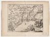
Novi Belgii, quod nunc Novi Jorck vocatur, Novae q[ue] Angliae & partis Virginiae : accuratissima et novissima delineatio
1 : 3500000 Montanus, Arnoldus, 1625?-1683 J. Meurs