Maps of Hamilton
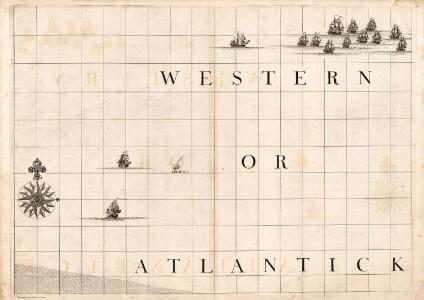
A Map of the British Empire in America. (Sheet 11).
1 : 2000000 Popple, Henry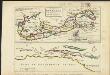
The island of Bermudos divided into its tribes, with the castles, forts &c. ; [Part of Providence Island]
1 : 1
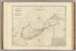
The Bermudas, or Summer's Islands
1 : 60000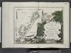
Le colonie unite dell' America settentrle ... [Title page]; Le Isole Bermude.
from Le colonie unite dell' America settentrle : di nuova projezione a s.s.e.e. li Signori Riformatori dello Studio di Padova.
Heathers, improved chart of the Bermudas, drawn from the best surveys
1 : 141000 Heather, W. (William) Heather, W. (William)
Mappa Aestivarum Infularum, alias Barmudas dictarum, ad Ostia Mexicani estuary jacentium in latitudine Graduum 32 Minutorum 25. Ab Anglia, Londino Scilicet versus Libonotum 3300 Miliaribus Anglicanis, ...
from America: being the latest, and most accurate description of the Nevv vvorld; containing the original of the inhabitants, and the remarkable voyages thither. The conquest of the vast empires of Mexico and Peru, and other large provinces and territories, with the several European plantations in those parts. Also their cities, fortresses, towns, temples, mountains, and rivers. Their habits, customs, manners, and religions. Their plants, beasts, birds, and serpents. With an appendix, containing, besides several other considerable additions, a brief survey of what hath been discover'd of the vnknown south-land and the Arctick region. Collected from most authentick authors, augmented with later observations, and adorn'd with maps and sculptures, by John Ogilby ...
British West Indian Possessions, Northern.
Fullarton, A. & Co.
Mappa Aestivarum Insularum, alias Barmudas dictarum, ad Ostia Mexicani [...] [Karte], in: Novus Atlas, das ist, Weltbeschreibung, Bd. 2, S. 322.
1 Karte aus Atlas Blaeu, Joan Blaeu, Willem Janszoon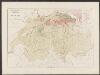
Mappa Aestivarum Insularum, alias Barmudas dictarum [...] accurate descripta. [Karte], in: Gerardi Mercatoris et I. Hondii Newer Atlas, oder, Grosses Weltbuch, Bd. 2, S. 389.
1 Karte aus Atlas Mercator, Gerhard und Hondius, Jodocus Jansson, Jan
Mappa Aestivarum Insularum, alias Barmudas dictarum [...] accurate descripta. [Karte], in: Theatrum orbis terrarum, sive, Atlas novus, Bd. 2, S. 324.
1 Karte aus Atlas Blaeu, Joan Blaeu, Willem Janszoon
Mappa Aestivarum Insularum, alias Barmudas dictarum [...] accurate descripta. [Karte], in: Novus atlas absolutissimus, Bd. 6, S. 213.
1 Karte aus Atlas Janssonius Offizin
The Bermudas, or Summer's Islands.
1 : 60000 Jefferys, Thomas
Mappa ÆSTIVARVM Insularum, | alias BARMVDAS dictarum, ad Ostia | Mexicani æstuarij jacentium in latitudine Gra- | duum 32 Minutorum 25. Ab Anglia, Londino | Scilicet versus Libonotum 3300 Miliaribus | Anglicanis, et a Roanoack (qui locus est | in Virginia) versus Euronotum 500 Mill. | accurate descripta
Amstelodami, Guiljelm. Blaeuw excudit
Bermudas.
1 : 79200 Lucas, Fielding Jr.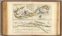
Island of Bermudos, Part of Providence Island.
Moll, Herman, d. 1732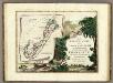
Le Isole Bermude.
1 : 2100000 Zatta, Antonio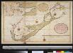
Nette afteekening vant eijland Barmuda anders genaamt Sommer Islands int groodt
Bermuda Gerard van Keulen
Bermuda.
1 : 53000 Rand McNally and Company
A Map of the British and French settlements in North America: (part the second) containing part of New York, Pensilvania, New Jersey, Mary Land, Virginia, North & South Carolina, Georgia, Louisiana, and all the countries westward in the same parellels so far as discovered, shewing the course of the Rivers Ohio, Missisipi &c. exhibiting the just boundaries & the French encroachments laid down from authentic surveys / T. Bowen, sc.
from Parts T. Bowen,
Canada et Louisiane
1 : 5000000 par le Sr. Le Rouge A Paris : [Le Rouge], Rue des Augustins]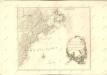

America Septentrionalis
1 : 1300000 Kanada západní Anville, Jean-Baptiste Bourguinon d' Homannianorum heredum
A map of the British-plantations on the continent of America / Stephens fecit.
from Charts and maps Stephens fecit,
A new map of the English empire in America: viz. Virginia, Maryland, Carolina, New York, New Iarsey, New England, Pennsylvania, Newfoundland, New France &c. / revis'd by Ion. Senex, 1719; I. Harris, sculp.
from John H. Levine Collection John Senex; I. Harris,
A new map of the English empire in America: viz. Virginia, Maryland, Carolina, New York, New Iarsey, New England, Pennsylvania, Newfoundland, New France &c. / revis'd by Ion. Senex, 1719; I. Harris, sculp.
from Charts and maps John Senex; I. Harris,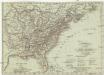
Vereinigte Staaten in Nord America
1 : 10000000 Spojené státy americké-oblast jihovýchodní T. Mollo
Map Of The United States Of Mexico.
1 : 5195520 Tanner, Henry S.
Carte nouvelle de l'Amerique angloise : contenant tout ce que les Anglois possedent sur le continent de l'Amerique septentrionale savoir le Canada, la Nouvelle Ecosse ou Acadie, les treize provinces unies qui sont: les quatres colonies de la Nouvelle Ang
from Charts and maps