Maps of Appalachian Mountains

Mitchell's Reference & Distance Map Of The United States.
1 : 1584000 Young, James H.
Mitchell's Reference & Distance Map Of The United States.
1 : 1584000 Young, James H.
United States.
1 : 1900800 Varle, Charles P.
Mitchell's Reference & Distance Map Of The United States.
1 : 1584000 Young, James H.
United States.
1 : 10700000 Carey, Mathew
United States.
1 : 10700000 Carey, Mathew
Karte der katholischen Diocesen und deren Missionen in Nordamerika nach den neuesten geographischen Angaben
1 : 22430000 Spojené státy americké-oblast východní Salzbacher, Joseph Engel, H. Joseph Salzbacher
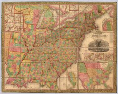
Mitchell's Reference & Distance Map Of The United States.
1 : 1584000 Young, James H.
Mitchell's Reference & Distance Map of the United States.
1 : 1584000 Young, James H.
Mitchell's National Map of the United States.
1 : 3360000 Mitchell, Samuel Augustus
Map of the United States.
1 : 1900800 Varle, Charles P.
Mitchell's map of the United States.
1 : 14752000 Mitchell, Samuel Augustus
United States.
1 : 1964160 Woodbridge, J.L.
United States.
from Whole s.n.: [London?],
Mitchell's Reference & Distance Map Of The United States.
1 : 1584000 Young, James H.
United States.
from Whole Published by Thomas & Andrews: [Boston]; Lewis, Samuel,
United States.
1 : 7603200 Melish, John
United States.
1 : 7603200 Melish, John
An improved map of the United States

United States of America.
1 : 5300000 Scott, Bradford
Die Vereinigten Staaten von Nord-America

Reference & Distance Map Of The United States.
1 : 1584000 Young, James H.
The Seat of Civil War in America.
The Seat of Civil War in America. Published by Smith & Son of London in August 1863, The Seat of Civil War in America highlights the Union and Confederate states, as well as clearly marking the Border States in yellow. Interestingly this map still presents Virginia as one state. The smaller map shows the Seat of War in Virginia, detailing the areas of the state closest to Maryland and Washington, D.C., as well as southern Pennsylvania. Smith & Son
An accurate map of the United States of America: according to the Treaty of Peace of 1783.
from Whole Published as the Act directs by H.D. (Henry Delahoy) Symonds: London; Russell, John,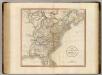
United States of America.
1 : 5900000 Cary, John, ca. 1754-1835
A new map of the United States of America, from the latest authorities / by John Cary, engraver.
from Whole John Cary,
Mitchell's National Map of the American Republic
1 : 3400000 Mitchell, Samuel Augustus
Mitchell's Reference & Distance Map Of The United States.
1 : 1584000 Young, James H.
Mitchell's Reference & Distance Map Of The United States.
1 : 1584000 Young, James H.