Maps of United Kingdom
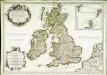
Great Britain & Ireland.
1 : 4250000 Bowen, Emanuel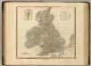
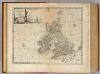
British Isles.
1 : 2550000 Cary, John, ca. 1754-1835
Grossbritanien und Ireland
Neuester Schul-Atlas Walch, Johann im Verlag bei Joh. Walch

Isles Britanniques.
1 : 2500000 L'Isle, Guillaume de, 1675-1726
Die Britischen Inseln
[Allgemeiner Atlas über alle Theile der Erde in 29 Blättern] Ziegler, Jakob Melchior Top. Anstalt v. J. Wurster u. Comp.
Anglia, Scotia et Hibernia. [Karte], in: Atlas, sive, Cosmographicae meditationes de fabrica mundi et fabricati figura, S. 80.
1 Karte aus Atlas Mercator, Gerhard
Anglia, Scotia et Hibernia. [Karte], in: Gerardi Mercatoris Atlas, sive, Cosmographicae meditationes de fabrica mundi et fabricati figura, S. 82.
1 Karte aus Atlas Mercator, Gerhard Montanus, Petrus
Great Britain and Ireland.
1 : 4100000 Gray, Ormando Willis
Die Britischen Inseln und das Umliegende Meer
Handatlas über alle Theile der Erde und über das Weltgebäude Stieler, Adolf Justus Perthes
58-59. Great Britain and Ireland. The World Atlas.
1 : 2500000 USSR (Union of Soviet Socialist Republics).
British Islands.
1 : 2300000 Lizars, Daniel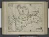
Paskaert, de Kusten van't Kanael, vertoonende alle, de Kusten van Engelandt, Schotlant, en Yerlandt, en een gedeelte van Vranckrijck.
from De zee-atlas ofte water-wereld : waer in vertoont werden alle de zee-kusten van het bekende des aerd-bodems : seer dienstigh voor alle heeren en kooplieden, als oock voor alle schippers en stuurlieden / by Pieter Goos.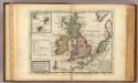
A general map of Great Britain and Ireland.
1 : 7500000 Moll, Herman, d. 1732
Les isles Britanniques qui comprennent les royaumes d'Angleterre, d'Ecosse et d'Irlande
1 Karte : Kupferdruck ; 46 x 58 cm Robert de Vaugondy; Haussard; Dussy G. et D. Robert de Vaugondy
Les isles britannicques ou sont le royaume d'Angleterre divisé en ses quatre roy.mes des Saxons
1 Karte : Kupferdruck ; 39 x 51 cm Sanson; Mariette; Speed; Gordon; Pont chez Pierre Mariette rue St. Iacques a l'Esperance
Les isles Britanniques
1 : 2600000 Anglie Sanson, Guillaume Boazius, I.B. chez H. Iaillot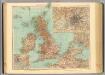
45-46. Gran Bretagna.
1 : 3000000 Touring club italiano
Les Isles Britanniques : ou sont le royaumes d'Angleterre tiré de Speed, celuy d'Ecosse tiré de Th. Pont et celuy d'Irlande tiré de Petit / le tout rectifié par diverses observations par G. de l'Isle
1 : 2650000 titelvariant: Magnae Britanniae tabula; Annotatie: Titel boven de kaart: Magnae Britanniae tabula : comprehendens Angliae, Scotiae, ac Hiberniae regna, ad usum serenissimi Burgundiae Ducis; Oorspr. verschenen in: Atlas nouveau ... / par Guillaume de l'Isle. - Amsterdam : Jean Covens & Corneille Mortier, 1730 Isle, Guillaume de l' Amsteldam : I. Covens & C. Mortier
Neueste Karte von Grossbritannien und Jreland
Grosser Hand-Atlas über alle Theile der Erde in 170 Karten Meyer, J. Verlag des Bibliographischen Instituts
Iles Britanniques.
1 : 2500000 Lapie, M. (Pierre), 1779-1850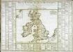
Tableau général des isles Britanniques
1 Karte : Kupferdruck ; 34 x 43 cm, Bildgrösse 52 x 73 cm Brion de la Tour; Le Campion; Le Campion chez les Campions freres m.ds d'estampes rue St. Jacques à la ville de Rouen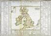
Tableau général des isles Britanniques
1 Karte : Kupferdruck ; 34 x 43 cm, Bildgrösse 52 x 73 cm Brion de la Tour; Le Campion; Le Campion chez les Campions freres m.ds d'estampes rue St. Jacques à la ville de Rouen
Magna Britannia, aut Anglia, Scotia et Hibernia
1 Karte : Kupferdruck ; 46 x 58 cm Valck; Valck G. und L. Valck
Grossbritanien und Irrland
Allgemeiner Atlas [Walch, Johannes] im Verlag bei Johannes Walch
Les isles Britanniques comprenant les royaumes d'Angleterre, Ecosse et Irlande
1 Karte : Kupferdruck ; 51 x 67 cm Crépy; Crépy chez Crepy rue S. Jacques à l'Image Saint
Magna Britannia
1 Karte : Kupferdruck ; 47 x 55 cm Homännische Erben
Magna Britannia
1 Karte : Kupferdruck ; 46 x 55 cm Homännische Erben
Les isles britanniques qui contiennent les royaumes d'Angleterre, Escosse, et Irlande
1 Karte : Kupferdruck ; 46 x 58 cm Jaillot; Ottens; Ottens chez Reinier et Iosua Ottens
Les isles britanniques qui contiennent les royaumes d'Angleterre, Escosse, et Irlande
1 Karte : Kupferdruck ; 46 x 58 cm Jaillot A. H. Jaillot