Maps of United Kingdom
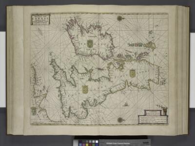
Paskaert, de Kusten van't Kanael, vertoonende alle, de Kusten van Engelandt, Schotlant, en Yerlandt, en een gedeelte van Vranckrijck.
from De zee-atlas ofte water-wereld : waer in vertoont werden alle de zee-kusten van het bekende des aerd-bodems : seer dienstigh voor alle heeren en kooplieden, als oock voor alle schippers en stuurlieden / by Pieter Goos.
Die Britischen Inseln
[Allgemeiner Atlas über alle Theile der Erde in 29 Blättern] Ziegler, Jakob Melchior Top. Anstalt v. J. Wurster u. Comp.
Les Isles Britanniques ou sont le royaumes d'Angleterre
1 : 2534400
Grossbritanien und Ireland
Neuester Schul-Atlas Walch, Johann im Verlag bei Joh. Walch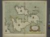
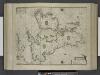
A new and correct chart of the sea coast of ENGLAND, SCOTLAND and IRELAND
from The sea-atlas : containing an hydrographical description of most of the sea-coasts of the known parts of the world.
Prima Europe Tabula [Karte], in: [Clavdii Ptholomei Cosmographi ...], S. 245.
1 Karte aus Atlas Nicolaus Germanus [und Ptolemaeus, Claudius]
INSVLÆ | ALBION | et | HIBERNIA | cum minoribus adjacentibus
[Amsterdam : Joan Blaeu]
45-46. Gran Bretagna.
1 : 3000000 Touring club italiano
Grossbritanien und Irrland
Allgemeiner Atlas [Walch, Johannes] im Verlag bei Johannes Walch
Neueste Karte von Grossbritannien und Jreland
Grosser Hand-Atlas über alle Theile der Erde in 170 Karten Meyer, J. Verlag des Bibliographischen Instituts
Great Britain and Ireland.
1 : 4100000 Gray, Ormando Willis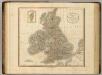
British Isles.
1 : 2550000 Cary, John, ca. 1754-1835
Die Brittischen Inseln
Schul-Atlas über alle Theile der Erde nach dem neuesten Zustande, und über das Weltgebäude Stieler, Adolf Justus Perthes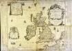
Les isles britaniques ou sont les royaumes d'Angleterre et d'Escosse que nous appellons la Grande Bretagne et celui d'Irlande
1 Karte auf 4 Blättern : Kupferdruck ; 72 x 86 cm Duval; Duval chez Mad.lle Du-Val fille de l'auteur sur le quay de l'Horloge du Palays pres la rue de Harlay a la couronne d'or
Carte des isles britaniques, où sont les royaumes d'Angleterre, et d'Escosse, que nous appellons Grande Bretagne
1 Karte : Kupferdruck ; 46 x 33 cm Duval chez l'auteur en l'isle du Palais sur le quay de l'Horloge
Carte des isles britaniques, où sont les royaumes d'Angleterre, et d'Escosse, que nous appellons Grande Bretagne
1 Karte : Kupferdruck ; 46 x 33 cm Duval chez l'auteur en l'isle du Palais sur le quay de l'Horloge
Different Routes of Prince Edward in Great Britain
Maps are usually made by conquerors. This is an exception: it was made by the side that lost. The map was drawn by James Grant, a French officer of Scottish descent who fought alongside Bonnie Prince Charlie throughout his campaigns, including the Battle of Culloden, and accompanied him on his flight to France. The map bears the royal arms of the Stuart kings and records in detail the battles and sieges of the Jacobite campaign. Allegorical figures, such as Justice, dignify the conflict. The Prince’s escape route is watched over from the clouds by the gods of classical mythology: Venus, Zephyr, Apollo, Mercury and Neptune. In a rebuttal of the English propaganda that followed the defeat of the Jacobite Uprising, the map is pointedly Inscrib’d to all the Honest. Grant, James A.
58-59. Great Britain and Ireland. The World Atlas.
1 : 2500000 USSR (Union of Soviet Socialist Republics).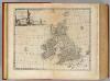
Great Britain & Ireland.
1 : 4250000 Bowen, Emanuel
Die Britischen Inseln und das Umliegende Meer
Handatlas über alle Theile der Erde und über das Weltgebäude Stieler, Adolf Justus Perthes
Les isles Britanniques comprenant les royaumes d'Angleterre, Ecosse et Irlande
1 Karte : Kupferdruck ; 51 x 67 cm Crépy; Crépy chez Crepy rue S. Jacques à l'Image Saint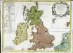
Les isles Britannicques ou sont le royaume d'Angleterre diuisé en ses quatre roy.mes des Saxons
1 Karte : Kupferdruck ; 52 x 71 cm Speed; Gordon; Pont s.n.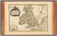
Isles Britanniques.
1 : 3800000 Janvier, Jean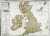
Carte des isles Britanniques qui renferment les royaumes d'Angleterre d'Ecosse [et] d'Irlande
1 Karte : Kupferdruck ; 53 x 59 cm Robert de Vaugondy; Beaublé; Fortin; Kitchin chés Fortin ingénieur du roi pour les globes et sphéres rue de la Harpe près celle du Foin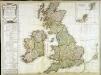
Carte des isles Britanniques qui renferment les royaumes d'Angleterre d'Ecosse [et] d'Irlande
1 Karte : Kupferdruck ; 53 x 59 cm Robert de Vaugondy; Beaublé; Delamarche; Kitchin chez le Sr. Delamarche géographe rue du Foin St. Jacques au collège de m.tre Gervais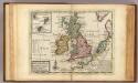
A general map of Great Britain and Ireland.
1 : 7500000 Moll, Herman, d. 1732
Grossbritannien
Plastischer Schul-Atlas über alle Theile der Erde : in 24 Karten Woldermann, G Verlag von P. Eckerlein
Kompas van Groot-Brittannië en Ierland
1 : 2000000 Annotatie: Met lijst van graafschappen; Annotatie geografische gegevens: Met schaalstok; Legenda; Inzetkrt.: [Orkaden en Shetland Eil.] Kompas, Den Haag Den Haag : Kompas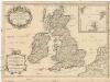
Les isles Britanniques
1 : 2600000 Anglie Sanson, Guillaume Boazius, I.B. chez H. Iaillot