Maps of United Kingdom
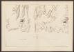
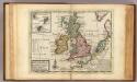
Anglia, Scotia et Hibernia. [Karte], in: Atlas, sive, Cosmographicae meditationes de fabrica mundi et fabricati figura, S. 80.
1 Karte aus Atlas Mercator, Gerhard
Anglia, Scotia et Hibernia. [Karte], in: Gerardi Mercatoris Atlas, sive, Cosmographicae meditationes de fabrica mundi et fabricati figura, S. 82.
1 Karte aus Atlas Mercator, Gerhard Montanus, Petrus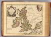
Isles Britanniques.
1 : 2500000 L'Isle, Guillaume de, 1675-1726
Les Isles Britanniques : ou sont le royaumes d'Angleterre tiré de Speed, celuy d'Ecosse tiré de Th. Pont et celuy d'Irlande tiré de Petit / le tout rectifié par diverses observations par G. de l'Isle
1 : 2650000 titelvariant: Magnae Britanniae tabula; Annotatie: Titel boven de kaart: Magnae Britanniae tabula : comprehendens Angliae, Scotiae, ac Hiberniae regna, ad usum serenissimi Burgundiae Ducis; Oorspr. verschenen in: Atlas nouveau ... / par Guillaume de l'Isle. - Amsterdam : Jean Covens & Corneille Mortier, 1730 Isle, Guillaume de l' Amsteldam : I. Covens & C. Mortier
LES ISLES BRITANNIQUES
1 : 2500000 Anglie Jaillot, Alexis-Hubert H. Iaillot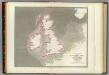
Tidal chart British Seas.
1 : 4900000 Russell, J. Scott (John Scott), 1808-1882
Tidal Chart of the British Seas
The physical atlas Johnston, Alexander Keith William Blackwood & Sons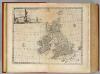
Great Britain & Ireland.
1 : 4250000 Bowen, Emanuel
Nieuwe kaart der Britsche Eilanden Engeland, Schotland en Irland.
1 : 6000000 [S.l.] : [s.n.]
Britannia prout divisa fuit temporibus Anglo-Saxonum, praesertim durante illorum Heptarchia [Karte], in: Theatrum orbis terrarum, sive, Atlas novus, Bd. 4, S. 87.
1 Karte aus Atlas Blaeu, Joan Blaeu, Willem Janszoon
A general map of Great Britain and Ireland.
1 : 7500000 Moll, Herman, d. 1732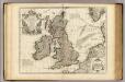
Isles Britanniques ou sont le Rme. d'Angleterre.
1 : 2600000 L'Isle, Guillaume de, 1675-1726
Grossbritanien und Ireland
Neuester Schul-Atlas Walch, Johann im Verlag bei Joh. Walch
Die Britischen Inseln und das Umliegende Meer
Handatlas über alle Theile der Erde und über das Weltgebäude Stieler, Adolf Justus Perthes
Britannia prout divisa fuit temporibus Anglo-Saxonum praesertim durante illorum Heptarchia. [Karte], in: Le théâtre du monde, ou, Nouvel atlas contenant les chartes et descriptions de tous les païs de la terre, Bd. 4, S. 81.
1 Karte aus Atlas Blaeu, Willem Janszoon und Blaeu, Joan Blaeu, Willem Janszoon
British Isles - Physical Geography..
Milner, Thomas
Die Britischen Inseln
[Allgemeiner Atlas über alle Theile der Erde in 29 Blättern] Ziegler, Jakob Melchior Top. Anstalt v. J. Wurster u. Comp.
MAGNAE BRITANNIAE TABULA
1 : 3170000 Anglie Visscher, Nicolaes Jansz. per Nicolaum Visscher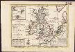
A general map of Great Britain and Ireland, with part of Germany, Holland, Flanders, France &c. agreeable to modern history
1 : 6500000
[Die Britischen Inseln: Übersicht der Völker und Sprachen]
Zweiter Band, enthaltend in vier Abtheilungen die Vertheilung der Organismen: 5. Pflanzen-Geographie, 6. Thier-Geographie, 7. Anthropographie, 8. Ethnographie Humboldt, Alexander von Verlag von Justus Perthes
Britannia prout divisa fuit temporibus Anglo-Saxonum, praesertim durante illorum Heptarchia [Karte], in: Novus atlas absolutissimus, Bd. 7, S. 88.
1 Karte aus Atlas Janssonius Offizin
Magnae Britanniae et Hiberniae Nova Descriptio [Karte] Orcades Insulae. [Nebenkarte], in: Novus atlas absolutissimus, Bd. 7, S. 29.
1 Karte aus Atlas Janssonius Offizin
ANGLIAE SCOTIAE et HIBERNIAE Regna
Anglie
Britannia prout divisa fuit temporibus Anglo-Saxonum, praesertim durante illorum Heptarchia [Karte], in: Theatrum orbis terrarum, sive, Atlas novus, Bd. 4, S. 87.
1 Karte aus Atlas Blaeu, Joan Blaeu, Willem Janszoon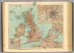
45-46. Gran Bretagna.
1 : 3000000 Touring club italiano
Les Isles Britanniques

Die Brittischen Inseln und die Nord-See
Hand-Atlas über alle Theile der Erde nach dem neuesten Zustande und über das Weltgebäude Stieler, Adolf bei Justus Perthes
Nieuwe kaart van de eilanden van Groot Brittannien : behelzende de koningryken Engeland, Schotland en Ierland / volgens de laatste waarnemingen in het ligt gebragt ; C. Sepp del. et sculps. 1743
1 : 3500000 Annotatie: Oorspr. verschenen in: Nieuwe hand-atlas ... - Amsterdam : Isaak Tirion, 1744 Sepp, C. Te Amsterdam : by Isaak Tirion
![Anglia, Scotia et Hibernia. [Karte], in: Atlas, sive, Cosmographicae meditationes de fabrica mundi et fabricati figura, S. 80.](https://images-2.georeferencer.com/images/iiif/055556123033/full/,300/0/native.jpg)

