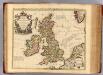
Maps of United Kingdom

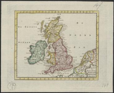
Nieuwe kaart der Britsche Eilanden Engeland, Schotland en Irland.
1 : 6000000 [S.l.] : [s.n.]
Britannia prout divisa fuit temporibus Anglo-Saxonum, praesertim durante illorum Heptarchia [Karte], in: Theatrum orbis terrarum, sive, Atlas novus, Bd. 4, S. 87.
1 Karte aus Atlas Blaeu, Joan Blaeu, Willem Janszoon
LES ISLES BRITANNIQUES
1 : 2500000 Anglie Jaillot, Alexis-Hubert H. Iaillot
Les Isles Britanniques : ou sont le royaumes d'Angleterre tiré de Speed, celuy d'Ecosse tiré de Th. Pont et celuy d'Irlande tiré de Petit / le tout rectifié par diverses observations par G. de l'Isle
1 : 2650000 titelvariant: Magnae Britanniae tabula; Annotatie: Titel boven de kaart: Magnae Britanniae tabula : comprehendens Angliae, Scotiae, ac Hiberniae regna, ad usum serenissimi Burgundiae Ducis; Oorspr. verschenen in: Atlas nouveau ... / par Guillaume de l'Isle. - Amsterdam : Jean Covens & Corneille Mortier, 1730 Isle, Guillaume de l' Amsteldam : I. Covens & C. Mortier
Anglia, Scotia et Hibernia. [Karte], in: Atlas, sive, Cosmographicae meditationes de fabrica mundi et fabricati figura, S. 80.
1 Karte aus Atlas Mercator, Gerhard

Anglia, Scotia et Hibernia. [Karte], in: Gerardi Mercatoris Atlas, sive, Cosmographicae meditationes de fabrica mundi et fabricati figura, S. 82.
1 Karte aus Atlas Mercator, Gerhard Montanus, Petrus
Britannia prout divisa fuit temporibus Anglo-Saxonum, praesertim durante illorum Heptarchia [Karte], in: Novus atlas absolutissimus, Bd. 7, S. 88.
1 Karte aus Atlas Janssonius Offizin
England, Schottland und Irland
Schul-Atlas in 36 Karten Völter, Daniel Verlag der J.M. Dannheimer'schen Buchhandlung
Britannia prout divisa fuit temporibus Anglo-Saxonum praesertim durante illorum Heptarchia. [Karte], in: Le théâtre du monde, ou, Nouvel atlas contenant les chartes et descriptions de tous les païs de la terre, Bd. 4, S. 81.
1 Karte aus Atlas Blaeu, Willem Janszoon und Blaeu, Joan Blaeu, Willem Janszoon
Magnae Britanniae et Hiberniae Nova Descriptio [Karte] Orcades Insulae. [Nebenkarte], in: Novus atlas absolutissimus, Bd. 7, S. 29.
1 Karte aus Atlas Janssonius Offizin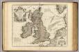
Isles Britanniques ou sont le Rme. d'Angleterre.
1 : 2600000 L'Isle, Guillaume de, 1675-1726
Nieuwe en perfeckte caerte van Engelandt, Schotlandt en Yerlandt
1 : 2470000 [Amsterdam] : nieuwelijck uyt gegeven bij Hugo Allardt, in de Calverstraet inde Werrelt Caert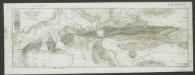
Magnae Britanniae et Hiberniae Tabula [Karte] Orcades Insulae [Nebenkarte], in: Le théâtre du monde, ou, Nouvel atlas contenant les chartes et descriptions de tous les païs de la terre, Bd. 4, S. 18.
1 Karte aus Atlas Blaeu, Willem Janszoon und Blaeu, Joan Blaeu, Willem Janszoon
Britannia prout divisa fuit temporibus Anglo-Saxonum, praesertim durante illorum Heptarchia [Karte], in: Theatrum orbis terrarum, sive, Atlas novus, Bd. 4, S. 87.
1 Karte aus Atlas Blaeu, Joan Blaeu, Willem Janszoon
Magnae Britanniae et Hiberniae Tabula [Karte] [Orcades Insulae] [Nebenkarte], in: Theatrum orbis terrarum, sive, Atlas novus, Bd. 4, S. 16.
1 Karte aus Atlas Blaeu, Joan Blaeu, Willem Janszoon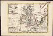
A general map of Great Britain and Ireland, with part of Germany, Holland, Flanders, France &c. agreeable to modern history
1 : 6500000
Magnae Britanniae et Hiberniae Tabula [Karte] Orcades Insulae [Nebenkarte], in: Novus Atlas, das ist, Weltbeschreibung, Bd. 3, S. 358.
1 Karte aus Atlas Blaeu, Joan Blaeu, Willem Janszoon
Magnae Britanniae et Hiberniae Tabula [Karte] [Orcades Insulae] [Nebenkarte], in: Theatrum orbis terrarum, sive, Atlas novus, Bd. 4, S. 16.
1 Karte aus Atlas Blaeu, Joan Blaeu, Willem Janszoon
Tidal Chart of the British Seas
The physical atlas Johnston, Alexander Keith William Blackwood & Sons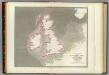
Tidal chart British Seas.
1 : 4900000 Russell, J. Scott (John Scott), 1808-1882
[Die Britischen Inseln: Übersicht der Völker und Sprachen]
Zweiter Band, enthaltend in vier Abtheilungen die Vertheilung der Organismen: 5. Pflanzen-Geographie, 6. Thier-Geographie, 7. Anthropographie, 8. Ethnographie Humboldt, Alexander von Verlag von Justus Perthes
Les Isles Britanniques
Isles Britanniques.
1 : 2500000 L'Isle, Guillaume de, 1675-1726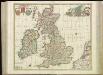
[85][85] Nova totius Angliae, Scotiae, et Hiberniae tab:, uit: Atlas sive Descriptio terrarum orbis
Annotatie: Gedigitaliseerde versie. Amsterdam. Heiloo : Picturae (vervaardiger), 2015. tiff-bestand. Gedigitaliseerd: 07-01-2015; Origineel: Universiteitsbibliotheek Vrije Universiteit (XL.05127.-) ; Netherlands; Titelpagina ontbreekt Wit, Frederik de Amsterdam : Frederick de Wit
Die Britischen Inseln und die Nord-See
Hand-Atlas über alle Theile der Erde nach dem neuesten Zustande und über das Weltgebäude Stieler, Adolf bei Justus Perthes
Die Brittischen Inseln und die Nord-See
Hand-Atlas über alle Theile der Erde nach dem neuesten Zustande und über das Weltgebäude Stieler, Adolf bei Justus Perthes
Carte des isles Britanniques
1 : 2600000 Irsko Nolin, Jean-Baptiste Daumont chez Daumont
Magnae Britanniae et Hiberniae Tabula. [Karte] Orcades Insulae [Nebenkarte], in: Gerardi Mercatoris et I. Hondii Newer Atlas, oder, Grosses Weltbuch, Bd. 1, S. 51.
1 Karte aus Atlas Mercator, Gerhard und Hondius, Jodocus Jansson, Jan