Maps of Hoboken
Hoboken - Plate D. Sub-Plan to Jersey City.
Hopkins, G.M.
The city of New York / Will L. Taylor, chief draughtsman.
from Whole
8C - N.Y. City (Aerial Set).
from Sectional aerial maps of the City of New York / [photographed and assembled under the direction of the chief engineer, July 1st, 1924].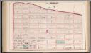
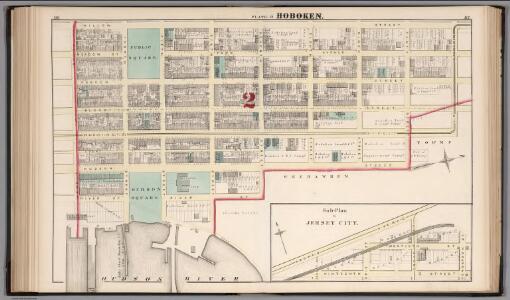
Hoboken - Plate C.
Hopkins, G.M.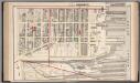
Hoboken - Plate B.
Hopkins, G.M.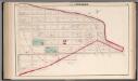
Hoboken - Plate E.
Hopkins, G.M.
Plan of Weehawken township.
from Combined atlas of the State of New Jersey and the County of Hudson : from actual survey, official records & private plans / by and under the direction of G. M. Hopkins ...
[Volume 7 Index Map.]
from Maps of the city of New York / surveyed under directions of insurance companies of said city.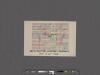
[Maps of the 14, 15, 16, 17, 20, 21 assembly districts and 23 & 24 Wards of New York City.]
From Manhattan
Topographical Atlas Of The City Of New York
1 : 12000 Viele, Egbert L.
Firemen's guide and map of the city of New-York shewing the boundaries of the proposed new fire districts / enlered according to Act of Congress in the year 1840 by George Hayward
1 Mapa, b/n. Dins (?): Valentine's manual of New York city, 1841-1870 Hayward, George G. Hayward's Lith. G. Hayward's Lith.
Plan von New-York, 1844.
from Manhattan
Topographical Atlas Of The City Of New York
1 : 12000 Viele, Egbert L.
Strangers guide through the city of New York : with the latest improvements / by H. Phelps.
from Manhattan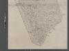
Map of New York City from Battery to 60th Street.
From Manhattan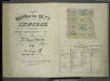
[Volume 6 Index Map.]
from Maps of the city of New York / surveyed under directions of insurance companies of said city.
Plan Of New York &c.
1 : 31300 Mitchell, Samuel Augustus
New map of that part of the city of New York south from 20th Street on the Hudson & 35th Street on the East River : showing the position of Greenwich, Washington and West Streets on the Hudson River, and Pearl, Water, Front, Cherry & Tompkins Sts. on the
from Manhattan
Area District Map Section No. 8
from Area district map / City of New York, Board of Estimate and Apportionment.
City of New-York / by David H. Burr.
from Manhattan
Height District Map Section No. 8
from Height district map / City of New York, Board of Estimate and Apportionment.
City of New-York / W. Kemble.
from Manhattan
Use District Map Section No. 8
from Use district map / City of New York, Board of Estimate and Apportionment.
New map of the city of New York with part of Brooklyn & Williamsburg / by J. Calvin Smith ; engraved on steel by Stiles, Sherman & Smith.
from Manhattan
Map of the lower section of the city of New York : showing high and low water lines.
From Manhattan
Map Of The City Of New York
1 : 12500 Ensign, Bridgman & Fanning
Area District Map Section No. 12
From Area district map.
Map of New York City, south of 46th St. : showing new arrangement of docks, piers, and water frontage, also soundings and former high water line
1 : 7200 Dripps, M. (Matthew) Matthew Dripps
Map of the City of New-York with part of Brooklyn and Williamsburgh : population in the year 1850: 450,000 inhabitants.
from Manhattan