Maps of Union City
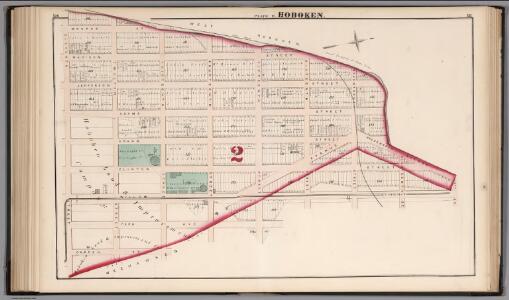
Hoboken - Plate E.
Hopkins, G.M.
Plan of Weehawken Township.
1 : 9600 Hopkins, G.M.
8C - N.Y. City (Aerial Set).
from Sectional aerial maps of the City of New York / [photographed and assembled under the direction of the chief engineer, July 1st, 1924].
The city of New York / Will L. Taylor, chief draughtsman.
from Whole
Jersey City, V. 1, Double Page Plate No. 12 [Map bounded by Paterson Plank Rd., Jackson St., South St., Nelson Ave., Secaucus Rd.] / compiled under the direction of and published by G.M. Hopkins Co.
From V. 1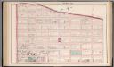
Hoboken - Plate C.
Hopkins, G.M.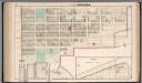
Hoboken - Plate D. Sub-Plan to Jersey City.
Hopkins, G.M.
Hudson County, V. 8, Double Page Plate No. 3 [Map bounded by Kerrigan Ave., Charles St., Courtland St., Bergen Wood] / surveyed and published by Chas. B. Brush. Vol. 8.
From Insurance maps of Hudson County, New Jersey
Hudson County, V. 8, Double Page Plate No. 5 [Map bounded by Kerrigan Ave., Oak St., West St., Charles St.] / surveyed and published by Chas. B. Brush. Vol. 8.
From Insurance maps of Hudson County, New Jersey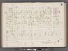
Hudson County, V. 8, Double Page Plate No. 6 [Map bounded by West St., Oak St., Palisade Ave., Charles St.] / surveyed and published by Chas. B. Brush. Vol. 8.
From Insurance maps of Hudson County, New Jersey
Plan of Weehawken township.
from Combined atlas of the State of New Jersey and the County of Hudson : from actual survey, official records & private plans / by and under the direction of G. M. Hopkins ...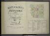
[Volume 7 Index Map.]
from Maps of the city of New York / surveyed under directions of insurance companies of said city.
[Maps of the 14, 15, 16, 17, 20, 21 assembly districts and 23 & 24 Wards of New York City.]
From Manhattan
[Volume 6 Index Map.]
from Maps of the city of New York / surveyed under directions of insurance companies of said city.
Plan Of New York &c.
1 : 31300 Mitchell, Samuel Augustus
New map of that part of the city of New York south from 20th Street on the Hudson & 35th Street on the East River : showing the position of Greenwich, Washington and West Streets on the Hudson River, and Pearl, Water, Front, Cherry & Tompkins Sts. on the
from Manhattan
Area District Map Section No. 8
from Area district map / City of New York, Board of Estimate and Apportionment.
Height District Map Section No. 8
from Height district map / City of New York, Board of Estimate and Apportionment.
Use District Map Section No. 8
from Use district map / City of New York, Board of Estimate and Apportionment.
Map of the lower section of the city of New York : showing high and low water lines.
From Manhattan
Map of New York City, south of 46th St. : showing new arrangement of docks, piers, and water frontage, also soundings and former high water line
1 : 7200 Dripps, M. (Matthew) Matthew Dripps
Map of the City of New-York with part of Brooklyn and Williamsburgh : population in the year 1850: 450,000 inhabitants.
from Manhattan
This actual map and comparative plans showing 88 years growth of the City of New York : is inscribed to the citizens by the proprietor, David Longworth / G.B. King sc. N.Y. 1817 ; engraved by Jas. D. Stout.
from Manhattan
Map of the City of New York.
from Manhattan
Map of the city of New York with the adjacent cities of Brooklyn and Jersey City, and the village of Williamsburg
1 : 14000 Story & Atwood H. Phelps
New York (City).
1 : 24000 Goodrich, S.G.
New York.
1 : 24000 Bradford, Thomas G.
Map of the city of New-York / drawn by D.H. Burr, for "New York as it is, in 1834" ; engraved by S. Stiles & Co., New York.
from Manhattan
Map of the City of New-York with part of Brooklyn and Williamsburgh : population in the year 1850: 450,000 inhabitants / D. Völker, sc.
from Manhattan