Maps of Hoboken

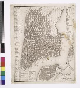
Plan von New-York, 1844.
from Manhattan
Firemen's guide and map of the city of New-York shewing the boundaries of the proposed new fire districts / enlered according to Act of Congress in the year 1840 by George Hayward
1 Mapa, b/n. Dins (?): Valentine's manual of New York city, 1841-1870 Hayward, George G. Hayward's Lith. G. Hayward's Lith.
City of New-York / by David H. Burr.
from Manhattan
City of New-York / W. Kemble.
from Manhattan
Map of the lower section of the city of New York : showing high and low water lines.
From Manhattan
Map Of The City Of New York
1 : 12500 Ensign, Bridgman & Fanning
The Firemen's guide : a map of the City of New-York, showing the fire districts, fire limits, hydrants, public cisterns, stations of engines, hooks & ladders, hose carts, &c.
from Manhattan
This actual map and comparative plans showing 88 years growth of the City of New York : is inscribed to the citizens by the proprietor, David Longworth / G.B. King sc. N.Y. 1817 ; engraved by Jas. D. Stout.
from Manhattan
Map of the City of New-York with part of Brooklyn and Williamsburgh : population in the year 1850: 450,000 inhabitants.
from Manhattan
New map of the city of New York with part of Brooklyn & Williamsburg / by J. Calvin Smith ; engraved on steel by Stiles, Sherman & Smith.
from Manhattan
Map of the City of New York.
from Manhattan
Strangers guide through the city of New York : with the latest improvements / by H. Phelps.
from Manhattan
New-York.
from The American traveller ; or, Guide through the United States, containing brief notices of the several states, cities, principal towns, canals and rail roads, etc. ; with tables of distances by stage, canal and steam boat routes ... by H.S. Tanner.
Map of the city of New York, shewing the original high water line and the location of the different farms and estates
Common Council
City of New-York
1 : 12500 Burr, David H., 1803-1875 Edward Walker
Map of the city of New York with the adjacent cities of Brooklyn and Jersey City, and the village of Williamsburg
1 : 14000 Story & Atwood H. Phelps
Map of New York City, south of 46th St. : showing new arrangement of docks, piers, and water frontage, also soundings and former high water line
1 : 7200 Dripps, M. (Matthew) Matthew Dripps
Outline and Index Map of Atlas of New York City.
from Atlas of the borough of Manhattan, city of New York.
New York (City).
1 : 24000 Goodrich, S.G.
New York.
1 : 24000 Bradford, Thomas G.
Map of the city of New-York extending northward to Fiftieth St. / surveyed and drawn by John F. Harrison, C.E.
from Manhattan
Map of the city of New-York / drawn by D.H. Burr, for "New York as it is, in 1834" ; engraved by S. Stiles & Co., New York.
from Manhattan
Area District Map Section No. 12
From Area district map.
New York S.
1 : 21120 Letts, Son & Co.
Map of New York City from Battery to 60th Street.
From Manhattan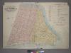
Outline & Index Map of Volume One, Atlas of New York City, Borough of Manhattan: Battery to Fourteenth Street.
from Atlas of the city of New York, borough of Manhattan. From actual surveys and official plans / by George W. and Walter S. Bromley.
Hooker's new pocket plan of the city of New York / compiled & surveyed by William Hooker, engraver, No. 179 Water Street, New York, house, Willoughby St., Brooklyn.
from Manhattan
A new map of the city of New York : comprising all the late improvements, compiled and corrected from authentic documents.
from Manhattan
Use District Map Section No. 12
from Use district map / City of New York, Board of Estimate and Apportionment.