Maps of Canadian Shield
L'Amerique Septentrionale 1.
1 : 10050000 Bonne, Rigobert, 1727-1794
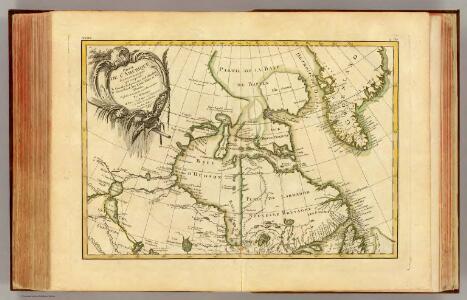
La Baja D'Hudson Terra di Labrador e Groenlandia.
1 : 9750000 Zatta, Antonio
North America...N.E. Sheet.
1 : 7500000 Tanner, Henry S.
North America...N.E. Sheet.
1 : 7500000 Tanner, Henry S.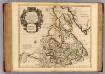
Canada, Nouvelle France.
1 : 9000000 L'Isle, Guillaume de, 1675-1726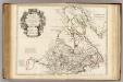
Canada, Nouvelle France.
1 : 9000000 L'Isle, Guillaume de, 1675-1726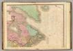
North America, N.E.. Sheet.
1 : 7600000 Tanner, Henry S.
Greenland, Labrador.
1 : 15000000 Peterson, Augusts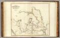
Arctic Regions.
1 : 19000000 Thomson, John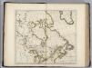
British Possessions in North America.
1 : 9100000 Carey, Mathew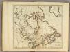
British Possessions in North America.
1 : 9000000 Carey, Mathew
British Possessions in North America.
1 : 6969600 Carey, Mathew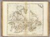
British Possessions in North America.
1 : 7603200 Carey, Mathew
British Possessions in North America.
1 : 7286400 Lewis, Samuel
British Possessions in North America.
1 : 7603200 Carey, Mathew
Septemtrionaliora Americæ à Groenlandia, per freta Davidis et Hudson, ad Terram Novam
1 Karte : Kupferdruck ; 48 x 55 cm Renard Louis Renard
[142][145] Septemtrionaliora Americae à Groenlandia, ..., uit: Atlas sive Descriptio terrarum orbis
Annotatie: Gedigitaliseerde versie. Amsterdam. Heiloo : Picturae (vervaardiger), 2015. tiff-bestand. Gedigitaliseerd: 07-01-2015; Origineel: Universiteitsbibliotheek Vrije Universiteit (XL.05127.-) ; Netherlands; Titelpagina ontbreekt Wit, Frederik de Amsterdam : Frederick de Wit
Partie orientale du Canada ou de la Nouvelle France : ou sont les provinces, ou pays de Sagvenay, Canada, Acadie etc., les peuples, ou nations des Etechemins, Iroquois, Attiquameches etc., auec la Nouvelle Angleterre, la Nouvelle Ecosse, la Nouvelle Yorc
from Charts and maps
Groenland und die angraenzenden Laender nach den Charten und Berichten von Cranz, Egede, Gieseke, Graah, Olavsen, Parry, Ross, Scoresby, Thorhallesen u.a.
1 : 5000000 entworfen und gezeichnet von Theodor Gliemann Weimar : Verlag des Geograph. Instituts
The north west part of America / by Robt. Morden.; Geography rectified, or, A description of the world: in all its kingdoms, provinces, countries, islands, cities, towns, seas, rivers, bayes, capes, ports: their antient and present names, inhabitants, situations, histories, customs, governments, &c.: as also their commodities, coins, weights, and measures, compared with those at London: illustrated with above sixty new maps: the whole work performed according to the more accurate discoveries of modern authors / by Robert Morden.
from Geography rectified, or, A description of the world : in all its kingdoms, provinces, countries, islands, cities, towns, seas, rivers, bayes, capes, ports : their antient and present names, inhabitants, situations, histories, customs, governments, &c. : as also their commodities, coins, weights, and measures, compared with those at London : illustrated with above sixty new maps : the whole work performed according to the more accurate discoveries of modern authors / by Robert Morden. Morden, Robert; Cockerill, Thomas,
Carte marine, de la B. de Baffin, et une partie d'Hudson, d'Island et Groenland
1 Karte : Kupferdruck ; 42 x 48 cm Königliche Akademie der Wissenschaften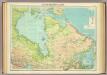
North-eastern Canada.
1 : 5000000 John Bartholomew and Son
Paskaert van de Noordelijckste kuste van America van Groenland door de Straet Davis en de Straet Hudson tot Terra Neuf
1 : 8000000 Colom, Jacob Aertsz Colom, Jacob Aertsz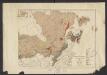
Geology. East sheet
1 : 6336000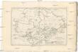
Canada
1 : 10120000 Kanada Bonne, Rigobert André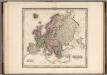
Europe.
1 : 11721600 Tanner, Henry S.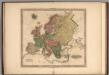
Europe.
1 : 11721600 Tanner, Henry S.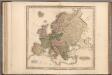
Europe.
1 : 11721600 Tanner, Henry S.
Europe.
1 : 11721600 Tanner, Henry S.