Maps of Ontario

Maps of Ontario

$title$

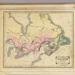
British Provinces of North America.

1 : 10000000 Cornell, S. S. (Sarah S.)
$title$

Geology. East sheet

1 : 6336000
$title$

Canada

1 : 10120000 Kanada Bonne, Rigobert André
$title$

188-189. Canada, East. The World Atlas.

1 : 5000000 USSR (Union of Soviet Socialist Republics).
$title$

Map Of Upper And Lower Canada.

1 : 2217600 Lea, I.
$title$

Possessions anglaises.

1 : 4700000 Buchon, J. A. C.; Carey, H. C.; Lea, I.
$title$

Canada.

1 : 11088000 Lucas, Fielding Jr.
$title$

North-eastern Canada.

1 : 5000000 John Bartholomew and Son
$title$

Canada, Nova Scotia.

1 : 4800000 Thomson, John
$title$

Canada, N. pt. Louisiana.

1 : 7700000 Jefferys, Thomas
$title$

Canada - Ontario, Quebec, and Maritime Provinces. Pergamon World Atlas.

1 : 5000000 Polish Army Topography Service
$title$

Canada, N.B., N.S.

1 : 5100000 Hall, S. (Sidney)
$title$

British America.

1 : 10200000 Grigg, John
$title$

EXTREMA AMERICÆ | Versus Boream, ubi | TERRA NOVA | NOVA FRANCIA, Adjacentiaq.

Amstelaedami Io. Blaeu Exc.
$title$

(Vereinigte Staate)n v. Nordamerika II.

1 : 8000000 Berghaus, Heinrich; Flemming, Carl; Sohr, Karl
$title$

Canada.

1 : 8870400 Finley, Anthony
$title$

Canada.

1 : 9000000 Finley, Anthony
$title$

Map of the Northern and Middle States.

1 : 6950000 Morse, Jedidiah
$title$

A map of the northern and middle states

$title$

Map of the Northern and Middle States.

1 : 6900000 Morse, Jedidiah
$title$

British Provinces in Canada.

1 : 7247550 Fisher, Richard Swainson
$title$

Nouvelle France ou le Canada.

1 : 4000000 Robert de Vaugondy, Gilles, 1688-1766
$title$

Canada, New Brusnwick, and Nova Scotia.

1 : 6600000 Teesdale, Henry
$title$

A General Map of the Northern British Colonies in America.

1 : 3700000 Robert Sayer and John Bennett (Firm)
$title$

Upper & Lower Canada.

1 : 4700000 Cary, John, ca. 1754-1835
$title$

A new map of Upper & Lower Canada / from the latest authorities by John Cary, engraver.

from Canada John Cary,
$title$

Canada.

1 : 9000000 Tanner, Henry S.
$title$

A New and correct map of the British colonies in North America comprehending eastern Canada with the province of Quebec, New Brunswick, Nova Scotia, and the Government of Newfoundland: with the adjacent states of New England, Vermont, New York, Pennsylvania and New Jersey.

from Charts and maps Publish'd by Laurie & Whittle, 53 Fleet Street: London; Robert Laurie and James Whittle,
$title$

British colonies North America, New England.

1 : 3800000 Robert Laurie & James Whittle
$title$

A New and correct map of the British colonies in North America comprehending eastern Canada with the province of Quebec, New Brunswick, Nova Scotia, and the Government of Newfoundland: with the adjacent states of New England, Vermont, New York, Pennsylvania and New Jersey.

from John H. Levine Collection Publish'd by Laurie & Whittle, 53 Fleet Street: London; Robert Laurie and James Whittle,
© MapTiler © OpenStreetMap contributors
How does it work?
These instructions will show you how to find historical maps online.
Getting started
Type the place name in the search box to find the exact location. You can further adjust the search by zooming in and out.
Zoom
Zoom in and out with the buttons or use your mouse or touchpad natively.
Exact Area tool
Click here and draw a rectangle over the map to precisely define the search area.
Set filters
Narrow your search with advanced settings, such as Years (from/to), Fulltext, Publisher, etc.
Results
See the results of your search on the right side. You can scroll down to find more maps of this location.
?

Download OldMapsOnline Mobile