Maps of East Java
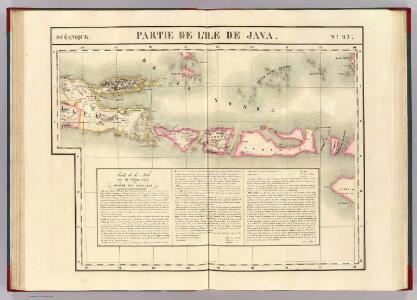
Partie, Java. Oceanique no. 27.
1 : 1641836 Vandermaelen, Philippe, 1795-1869
Singaradja / U.S. Army Map Service
U.S. Army Map Service Washington D.C. Washington D.C. : U.S. Army Map Service
Singaradja / samengesteld en gedrukt bij den Topografischen Dienst
Topografische Dienst Batavia Batavia : Topografische Dienst
Carte hypsométrique de l'Archipel des Indes Orientales / par P. Melvill de Carnbee
La Haye : Heyse
Oost Java : [geologische kaart]
1 : 1000000 Annotatie: Concept voor atlas van C. Lekkerkerker?; Met doorsnede van de hoogste bergtoppen (vertikale schaal 1:40.000) [S.l. : s.n.]
15. Kaart van de Kleine Soenda Eilanden, uit: Atlas van Nederlandsch Oost-Indië / samengest. door Topographisch Bureau te Batavia van 1897-1904
Annotatie: Omgewerkte versie van: Atlas der Nederlandsche bezittingen in Oost-Indië / naar de nieuste bronnen samengest. door J.W. Stemfoort en J.J. ten Siethoff. - 's-Gravenhage : Topographische Inrichting, [ca. 1885] Topographisch Bureau, Batavia 's-Gravenhage : Topographische Inrichting
Raba / Survey of India
Survey of India [S.l.] : Survey of India
Banjoewangi / Survey of India
Survey of India [S.l.] : Survey of India
Vulkan Karte von Ost Java
1 : 1300000 Jáva (Indonésie)
Kaart van het eiland Madura en de oosthoek van het eiland Java / door Js. van den Bosch ; gegraveerd door C. van Baarsel en Zoon
C. van Baarsel en Zoon s-Gravenhage ; Amsterdam : Gebroeders van Cleef
Ost-Java
1 : 1000000 Schulze, F. [s.n.]
5. Oost Java, uit: Atlas van Nederlandsch Oost-Indië / samengest. door Topographisch Bureau te Batavia van 1897-1904
Annotatie: Omgewerkte versie van: Atlas der Nederlandsche bezittingen in Oost-Indië / naar de nieuste bronnen samengest. door J.W. Stemfoort en J.J. ten Siethoff. - 's-Gravenhage : Topographische Inrichting, [ca. 1885] Topographisch Bureau, Batavia 's-Gravenhage : Topographische Inrichting
Kaart van de eilanden Balie en Lombok
1 : 650000 [Groningen] : ter steendrukkerij van A. Oomkens, J. zoon
t Vorstendom of Landschap Balamboang
[te Dordrecht : by Joannes van Braam]
Postiljon Eilanden / Survey of India
Survey of India [S.l.] : Survey of India
Sitoebondo / Survey of India
Survey of India [S.l.] : Survey of India
Kaart van Oost-Java : Derde militaire afdeeling / [door J.W Stemfoort en J.J. ten Siethoff ; gereproduceerd op last van het Departement van Koloniën, aan de Topographische Inrichting te 's-Gravenhage, onder leiding van den Directeur C.A. Eckstein]
Ministerie van Koloniën Den Haag s-Gravenhage : Departement van Koloniën
Oost-Java / Topografische Dienst
Topografische Dienst Batavia Batavia : Reproductiebedrijf Topografische Dienst
Oost-Java bijgewerkt tot 1 November 1935 / Reproductiebedrijf Topografische Dienst
Topografische Dienst Batavia Batavia : Topografische Dienst
Kaart der landbouw-ondernemingen in Oost-Java : (Soerabaja, Kediri, Pasoeroean, Probolinggo en Besoeki) / bewerkt naar de oorspronkelijke teekeningen van den heer H.Ph.Th. Witkamp ; uitgave van J.H. de Bussy Amsterdam, 1892
Amsterdam : J.H. de Bussy
Djember / Survey of India
Survey of India [S.l.] : Survey of India
Java en Madoera
1 : 1434000 Kuyper, J. Hugo Suringar
Pasoeroean / Survey of India
Survey of India [S.l.] : Survey of India
Idjen Hoogland en Bali = Idjen Highland and Bali / Reproductiebedrijf Topografische Dienst, Batavia
Topografische Dienst Batavia Batavia : Officieële Vereeniging voor Toeristenverkeer
Kaart van het eyland Bali
1 : 350000 [Dordrecht etc.] : J. van Braam en G. Onder de Linden exc.
Kaart van het eiland Bali / steendr[uk] v[an] E. Spanier te 's Hage
s-[Graven]hage : E. Spanier
[Ambulu]
1 : 200000 Joh. C. Stemler Cz.
Kaart van de Residentie Soerabaja / Topographisch Bureau
Topographisch Bureau Batavia Batavia : Topographisch Bureau
Overzichtskaart van de Residentie Besoeki / Topographisch Bureau
Topographisch Bureau Batavia Batavia : Topographisch Bureau