Maps of Jersey City

Greenwich Village, West Village, Little Italy. (cont.)
From District 2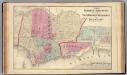
Hoboken, Jersey City.
1 : 19200 Beers, F. W. (Frederick W.)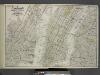
Map of New York, Brooklyn, Jersey City& c.
from Atlas of the Hudson River Valley from New York city to Troy, including a section of about 8 miles in width. Published by Watson & co. Compiled from official records and careful surveys, under the supervision of F. W. Beers.
Dutch Era Land Grants in Stokes Iconography sheet with Greenwich Village & Lower Manhattan.
from Manhattan
Topographical map of New York City, County and vicinity, showing old farm lines, etc. Based on Radell's and other official surveys, drawings and modern surveys.
From Manhattan
New York (City).
1 : 24000 Goodrich, S.G.
New York.
1 : 24000 Bradford, Thomas G.
Topographical atlas of the city of New York, including the annexed territory showing original water courses and made land. / prepared under the direction of Egbert L. Viele.
From Topographical atlas of the city of New York, including the annexed territory showing original water courses and made land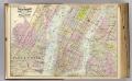
1 New York, Brooklyn, Jersey City.
1 : 18300 Watson, Gaylord
Topographical Atlas Of The City Of New York
1 : 12000 Viele, Egbert L.
Map of the city of New York, 1850 / drawn for D.T. Valentine's Manual 1850, by G. Hayward.
from Manhattan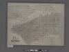
Map of the city of New York showing the original high water line and the location of the different farms and estates.
From Manhattan
Plan of New York
1 : 2000
New map of the city of New York.
from Manhattan
The Great metropolis in 1804.
from Manhattan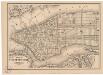
Map of the city of New York
1 mapa. Datat a partir de 1900 aproximadament. D. Appleton & Co.
Map of the local boundaries of the Protestant Episcopal Churches of the city of New York.
from Manhattan
New-York.
from The American traveller ; or, Guide through the United States, containing brief notices of the several states, cities, principal towns, canals and rail roads, etc. ; with tables of distances by stage, canal and steam boat routes ... by H.S. Tanner.
Topographical map of New York City, County and vicinity : showing old farm lines &c. / based on Randells and other official surveys, drawings and modern surveys by J.F. Harrison & T. Magrane ; printed by C. Wadlow.
from (A-Z)
Map of the city of New York : with street directory showing house-numbers, hotels, churches, banks, theatres, ferries, house-car, steam and elevated R.R'ds, &c
1 : 12670 Dripps, M. (Matthew) M. Dripps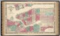
New York City.
1 : 20000 Johnson, A.J.
Plan of New York &c.
Mitchell, Samuel Augustus Jr.
New York.
from Manhattan
Map of the city of New York : with the adjacent cities of Brooklyn & Jersey City, & the village of Williamsburg / drawn & engraved by Story & Atwood, 151 Fulton St., N.Y.
from Manhattan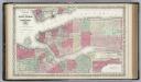
New York City and the Adjacent Cities.
1 : 20000 Colton, G.W.
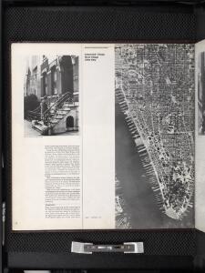
Lower Manhattan, The Battery, Wall Street, Civic Center, Governor's Island.
From District 1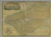
Map of the City of New York.
from Manhattan
Map of the City of New-York with part of Brooklyn and Williamsburgh : population in the year 1850: 450,000 inhabitants.
from Manhattan
[Volume 6 Index Map.]
from Maps of the city of New York / surveyed under directions of insurance companies of said city.