Maps of Jersey City

Jersey City, V. 1, Double Page Plate No. 31 [Map bounded by Thorne St., Hudson Blvd., Hackensack River, Pen Horn Creek] / compiled under the direction of and published by G.M. Hopkins Co.
From V. 1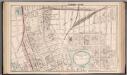
Jersey City - Plate I.
Hopkins, G.M.
Jersey City, V. 1, Double Page Plate No. 13 [Map bounded by Liberty Ave., Manhattan Ave., Oakland Ave., Newark Ave.] / compiled under the direction of and published by G.M. Hopkins Co.
From V. 1
Jersey City, V. 1, Double Page Plate No. 30 [Map bounded by Newark Ave., West Side Ave., Duncan Ave., Hackensack River] / compiled under the direction of and published by G.M. Hopkins Co.
From V. 1
Jersey City, V. 1, Double Page Plate No. 11 [Map bounded by South St., Marshall St., Franklin St., Manhattan Ave., Hudson Blvd.] / compiled under the direction of and published by G.M. Hopkins Co.
From V. 1
Topographical atlas of the City of New York / by Egbert L. Viele.
from Topographical atlas of the city of New York, / including the annexed territory showing original water courses and made land / prepared under the direction of Egbert L. Viele.
Jersey City, V. 1, Double Page Plate No. 32 [Map bounded by Secaucus Rd., Nelson Ave., Thorne St., Pen Horn Creek] / compiled under the direction of and published by G.M. Hopkins Co.
From V. 1
Jersey City, V. 1, Double Page Plate No. 15 [Map bounded by West Side Ave., Newark Ave., Summit Ave., Montgomery St.] / compiled under the direction of and published by G.M. Hopkins Co.
From V. 1
Jersey City, V. 1, Double Page Plate No. 12 [Map bounded by Paterson Plank Rd., Jackson St., South St., Nelson Ave., Secaucus Rd.] / compiled under the direction of and published by G.M. Hopkins Co.
From V. 1
Jersey City, V. 1, Double Page Plate No. 10 [Map bounded by Central Ave., Franklin St., Jersey Ave., 12th St., Washborn St., Oakland Ave.] / compiled under the direction of and published by G.M. Hopkins Co.
From V. 1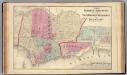
Hoboken, Jersey City.
1 : 19200 Beers, F. W. (Frederick W.)
Greenwich Village, West Village, Little Italy. (cont.)
From District 2
Dutch Era Land Grants in Stokes Iconography sheet with Greenwich Village & Lower Manhattan.
from Manhattan
Topographical map of New York City, County and vicinity, showing old farm lines, etc. Based on Radell's and other official surveys, drawings and modern surveys.
From Manhattan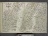
Map of New York, Brooklyn, Jersey City& c.
from Atlas of the Hudson River Valley from New York city to Troy, including a section of about 8 miles in width. Published by Watson & co. Compiled from official records and careful surveys, under the supervision of F. W. Beers.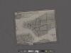
Amap of the city and county of New York, with the adjacent cities of Brooklyn and Jersey City, and the village of Williamsburg: with a street directory of the city of New York.
From Manhattan
Facsimile of the unpublished British head quarters coloured manuscript map of New York & environs / reproduced from the original drawing in the War Office, London.
from Whole
Citizens and Travelers' Guide map in, to, and from the City of New York and adjacent places.
From Manhattan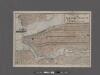
Elevated railway map of New York, Brooklyn, and Jersey City.
From Manhattan
Taunton's pocket edition of the merchant's and shipper's guide map to the port of New York / S.D.L. Taunton.
from Whole
Map of the cities of New York, Jersey City, Hoboken, with part of Brooklyn.
From Manhattan
King's bird's-eye view of Brooklyn
From Brooklyn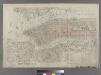
Outline & Index Map of New York City. Index I.
from Atlas of the city of New York : embracing all territory within its corporate limits from official records, private plans & actual surveys / by and under the supervision of E. Robinson & R.H. Pidgeon, civil engineers.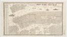
New York city map
Miller, James J. Miller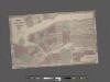
Johnson's Map of NYC.
From Manhattan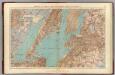
Brooklyn, N.Y. Bay, Jersey City, Hoboken, Bayonne, Newark Bay.
1 : 31680 Vermeule, C. C. (Cornelius Clarkson), 1858-1950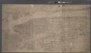
Topographical map of New York City, County and vicinity, showing old farm lines, etc. Based on Radell's and other official surveys, drawings and modern surveys.
From Manhattan
Newark-Paterson.
1 : 31680 Vermeule, C. C. (Cornelius Clarkson), 1858-1950
Map of New York City south of 118th street.
From Manhattan
![Jersey City, V. 1, Double Page Plate No. 31 [Map bounded by Thorne St., Hudson Blvd., Hackensack River, Pen Horn Creek] / compiled under the direction of and published by G.M. Hopkins Co.](https://images-2.georeferencer.com/images/iiif/922818114193/full/,300/0/native.jpg)

