Maps of Kings County

King's bird's-eye view of Brooklyn
From Brooklyn
Handy map of Brooklyn.
From Brooklyn
Outline & Index Map of the City of Brooklyn, Kings County, N.Y.
from Robinson's atlas of the city of Brooklyn, New York : embracing all territory within its corporate limits; from official records ... / by and under the supervision of E. Robinson and R.H. Pidgeon, civil engineers.
Map of the city of Brooklyn
From Brooklyn
Index Map to Volume One. Atlas of the Brooklyn Borough of the City of New York.
from Atlas of the Brooklyn borough of the City of New York : originally Kings Co.; complete in three volumes ... based upon official maps and plans ... / by and under the supervision of Hugo Ullitz, C.E.
Plate 2: Map of the City of Brooklyn, Long Island, N.Y.
from Atlas of Queens Co., Long Island, New York / compiled from official records, private plans & actual surveys by and under the direction of Chester Wolverton.
Brooklyn, N.Y. Bay, Jersey City, Hoboken, Bayonne, Newark Bay.
1 : 31680 Vermeule, C. C. (Cornelius Clarkson), 1858-1950
New map of the city of Brooklyn
From Brooklyn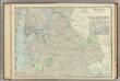
Brooklyn.
1 : 24500 Rand McNally and Company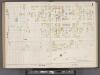
Hudson County, V. 8, Double Page Plate No. 1 [Map bounded by Spring St., Cortland St., Hillside Rd., Paterson Plank Rd.] / surveyed and published by Chas. B. Brush. Vol. 8.
From Insurance maps of Hudson County, New Jersey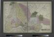
The City of Brooklyn.
from Atlas of Long Island, New York. From recent and actual surveys and records.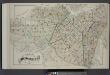
Index Map of Brooklyn
from Detailed estate and old farm line atlas of the city of Brooklyn : complete in six volumes ... from official records, private plans, and actual surveys ... / by G.M. Hopkins, C.E.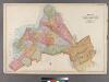
Plate 32: Map of the City of Brooklyn, Kings Co., N.Y.
from Robinson's atlas of Kings County, New York : compiled from official records ... / under the direction of E. Robinson.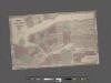
Johnson's Map of NYC.
From Manhattan
Guide map of Brooklyn, Kings County, N.Y. ....for Brooklyn daily eagle almanac.
From Brooklyn
Map of the cities of New York, Jersey City, Hoboken, with part of Brooklyn.
From Manhattan
Taunton's pocket edition of the merchant's and shipper's guide map to the port of New York / S.D.L. Taunton.
from Whole
Map of the City of Williamsburg with part of Greenpoint.
From Brooklyn
Brooklyn.
1 : 31000 Rand McNally and Company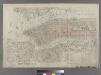
Outline & Index Map of New York City. Index I.
from Atlas of the city of New York : embracing all territory within its corporate limits from official records, private plans & actual surveys / by and under the supervision of E. Robinson & R.H. Pidgeon, civil engineers.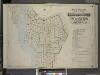
Index to Volume One, Atlas of the Borough of Brooklyn Sections 1, 2, 3 & 4. Wards 1, 2, 3, 4, 5, 6, 8, 9, 10, 12 & 22. City of New York. Published by E. Belcher Hyde, 97 Liberty St., Brooklyn. 1903.
from Wards 1, 2, 3, 4, 5, 6, 8, 9, 10, 12 & 22.
Aerial survey, Manhattan Island,New York City.
From Manhattan
Citizens and Travelers' Guide map in, to, and from the City of New York and adjacent places.
From Manhattan
Map of the city and county of New York, showing routes and stations of the elevated railroads.
From Manhattan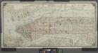
[Map of Manhattan from the Battery to 145th Street, showing adjacent portions of the Bronx, Long Island, and New Jersey]
from Manhattan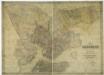
Map of the city of Brooklyn, as laid out by commissioners, and confirmed by acts of the Legislature of the state of New York : made from actual surveys, the farm lines and names of original owners, being accurately drawn from authentic sources, containin
from Brooklyn
Map showing the original high and low grounds, salt marsh and shore lines in the city of Brooklyn: from original government surveys made in 1776-7.
from Brooklyn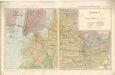
Hammods Atlas of New York City and the metropolitan district

Fire department of the city of Brooklyn.
From Brooklyn