Maps of Teaneck Township

Bergen County, V. 1, Double Page Plate No. 16 [Map bounded by Hackensack River, Madison Ave., Prospect Ave.] / by George W. and Walter S. Bromley.
From V. 1, 1912.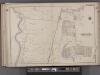
Bergen County, V. 1, Double Page Plate No. 15 [Map bounded by Washington Ave., Tryon Ave., Cedar Lane, Hackensack River] / by George W. and Walter S. Bromley.
From V. 1, 1912.
Hackensack
1 : 24000
Hackensack
1 : 24000
Hackensack
1 : 24000
Hackensack
1 : 24000
Hackensack
1 : 24000
Hackensack
1 : 31680
Hackensack
1 : 24000
1907 library map of Manhattan, City of New York.
From Manhattan
Geologic map and sections of Manhattan Island, State of New York
From Manhattan
Map of the Hudson ... from Spuyten Duyvil to P. Livingston's.
from Map of the Hudson between Sandy Hook & Sandy Hill : with the post road between New York and Albany / Bridges delt. ; Rollinson sct.
General map of the city of New York, consisting of boroughs of Manhattan, Brooklyn, Bronx, Queens and Richmond : consolidated into one municipality by act of the legislature of the state of New York (Chapter 378 of the laws of 1897) : showing in addition
from Whole
Colton's Map of the City of New York, prepared for the Department of Street Cleaning.
From Manhattan
Paterson, N.J. - N.Y., ed. of Feb. 1903, repr. 1924
from New Jersey, 15 minute series (topographic) / mapped, edited, and published by the Geological Survey.
Manhattan public and publicly aided housing
From The Borough
Westchester, Double Page Plate No. 2 [Map of City and County of new York] / prepared under the direction of Joseph R. Bien, from general surveys and official records.
From Atlas of Westchester County, New York
Manhattan Borough and part of Bronx Borough of the City of New York.
From Manhattan
Map of New York City showing portions of Brooklyn, Jersey City, and Westchester Co. on enlarged scale.
From Manhattan
Manhattan land use policy
From The Borough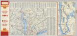
(Metropolitan New York and Long Island) Northern Section. To and Through Manhattan.
Shell Oil Company
TheHeart of Greater New York, showing commercial facilities and tentative plans of development and recent additions.
From Manhattan
Tibbits Brook route.
from Croton Water System
The Hudson by daylight map : showing the prominent residences, historic landmarks, old reaches of the Hudson, Indian names, &c.
from Hudson River
TheRand McNally map of the Borough of Manhattan, the principal portion of the Boroughs of Bronx, Brooklyn, and Queens and the business district of Jersey City.
From Manhattan
Manhattan Topography
From The Borough
New Guide Map of Manhattan and The Bronx.
From Manhattan
Watson's new map of the city of Brooklyn including Brooklyn
From Brooklyn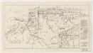
Map showing routes & stations on the dual system October, 1918
1 : 46000 New York (State). Public Service Commission State of New York Public Service Commission for the First District
![Bergen County, V. 1, Double Page Plate No. 16 [Map bounded by Hackensack River, Madison Ave., Prospect Ave.] / by George W. and Walter S. Bromley.](https://images-0.georeferencer.com/images/iiif/730984060897/full/,300/0/native.jpg)

