Maps of Bronx County

Country from Frog's Point to Croton River shewing the American and British Armies 1776.
1 : 120000 Marshall, John
Plaines Blanches et Armees Americaine et Britannique, 12 Octobre1776.
1 : 130000 Marshall, John
New York City and Vicinity.
1 : 30000 Walling, H. F.
New York Island, Part of Long Island .
1 : 100000 Marshall, John
Colton's driving & wheeling map of the country twenty five miles north of the city of New York.
1 : 73000 G.W. & C.B. Colton & Co.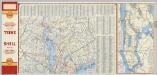
(Metropolitan New York and Long Island) Northern Section. To and Through Manhattan.
Shell Oil Company
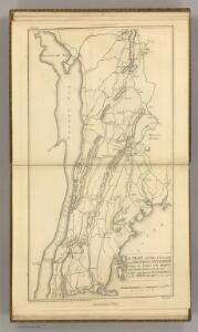
A plan of the country from Frogspoint to Croton River shewing the positions of the American and British armies from the 12th of October 1776 until the engagement on the White Plains on the 28th
1 : 128400 Lewis, Samuel Wayne, Caleb Parry
The Hudson by daylight map : showing the prominent residences, historic landmarks, old reaches of the Hudson, Indian names, &c.
from Hudson River
Map of New York City showing portions of Brooklyn, Jersey City, and Westchester Co. on enlarged scale.
From Manhattan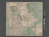
New Map of the Borough of the Bronx, City of New York . . . Circular stickers mark Carnegie Library sites.
From Bronx
New Guide Map of Manhattan and The Bronx.
From Manhattan
Harlem
1 : 62500
Harlem
1 : 62500
Harlem
1 : 62500
Harlem
1 : 62500
Harlem
1 : 62500
Harlem
1 : 62500
Harlem
1 : 62500
Harlem
1 : 62500
Harlem
1 : 62500
Harlem
1 : 62500
Harlem
1 : 62500
Harlem
1 : 62500
Harlem
1 : 62500
Harlem
1 : 62500
Harlem
1 : 62500
Harlem
1 : 62500
Harlem
1 : 62500
Harlem
1 : 62500
Harlem
1 : 62500
Harlem
1 : 62500