Maps of Kings County
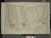
Queens, Vol. 2, Double Page Plate No. 21; Part od Ward Two Laurel Hill; [Map bounded by Newtown Ave., Berlin Ave., Newtown Creek; Including Laurel Hill Ave., Laurel Hill Boulevard]; Sub Plan No. 1; [Map bounded by Newtown Ave., Maurice Ave., Old
from First and second wards: Long Island City and Newtown.
Queens, Vol. 2, Double Page Plate No. 31; Part of Ward two Newtown; [Map bounded by Newtown Ave., Covert Ave. (Betts Ave.), Old Brook School Road, Maurice Ave.; Including Astoria Ave., Maspeth Ave., Road to Town Landing, Berlin Ave.]
from First and second wards: Long Island City and Newtown.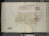
Queens, Vol. 2, Double Page Plate No. 30; Part of Ward Two Laurel Hill; [Map bounded by Berlin Ave., Newtown Creek, Laurel Hill Boulevard; Including Newtown Ave., Old Brook School Road, Newtown Turnpike]
from First and second wards: Long Island City and Newtown.
Queens, Vol. 2A, Double Page Plate No. 14; Part of Ward Two Newtown. [Map bounded by Maspeth Creek, Creek St., Maspeth Ave., Broad St., Pacific St.; Including Andrews St., Metropolitan Ave., newtown Creek] / by and under the supervision of Hugo Ullitz.
From v. 2A
Brooklyn V. 9, Plate No. 82 [Map bounded by Maspeth Ave., Newtown Creek, Grand St., Scott Ave.]
From Atlas 90. Vol. 9, 1907.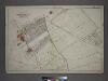
Part of the Borough of Queens, New town, Ward 2.
from Atlas of the city of New York, borough of Queens, Long Island City, Newtown, Flushing, Jamaica, Far Rockaway, from actual surveys and official plans / by George W. and Walter S. Bromley.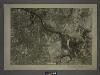
13A - N.Y. City (Aerial Set).
from Sectional aerial maps of the City of New York / [photographed and assembled under the direction of the chief engineer, July 1st, 1924].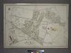
[Plate 7: Bounded by Maspeth Avenue, Maurice Avenue, Juniper Avenue, (Mount Olivet Cemetery) Fresh Pond Avenue, Metropolitan Avenue, Stanhope Street, Woodard Avenue,(Newtown Creek) Grand Street and Flushing Avenue.]
from Atlas of the city of New York, borough of Queens, Long Island City, Newtown, Flushing, Jamaica, Far Rockaway, from actual surveys and official plans / by George W. and Walter S. Bromley.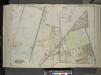
Queens, Vol. 2, Double Page Plate No. 33; Part of Ward Two Newtown; [Map bounded by Flushing Ave., Union Ave., Carrison Ave., Flushing Ave., Metropolitan Ave.; Including Stanhope St. (Summit St.), Boundary Line between boroughs of Queens and
from First and second wards: Long Island City and Newtown.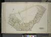
Queens, Vol. 2, Double Page Plate No. 28; Part of Ward Two Maspeth; [Map bounded by Maurice Ave., Fisk Ave., Grand St.; Including Maspeth Ave., Astoria Ave.]
from First and second wards: Long Island City and Newtown.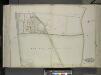
Queens, vol. 2, Double Page Plate No. 29; Part of Ward Two Newtown; [Map bounded by Greenpoint Ave., Newtown and Bushwick Turnpike (Shell Road), Maurice Ave.; Including Newtown Ave. (Penny Bride Road), Betts Ave., Thomson Ave.]
from First and second wards: Long Island City and Newtown.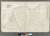
Plate 26: Part of Wards 17 & 18. City of Brooklyn.
from Atlas of the entire city of Brooklyn, complete in one volume. From actual surveys and official records by G. W. Bromley & Co.
Queens V. 3, Plate No. 58 [Map bounded by Maurice Ave., Jackson Ave., Jefferson Ave., North Hempstead Plank Rd., Lexington Ave.]
From Atlas 137. Vol. 3, 1902.
Part of Wards 17 & 18. Land Map Sections, No. 9 & 10, Volume 1, Brooklyn Borough, New York City.
from Atlas of the Brooklyn borough of the City of New York : originally Kings Co.; complete in three volumes ... based upon official maps and plans ... / by and under the supervision of Hugo Ullitz, C.E.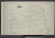
Vol. 2. Plate, B. [Map bound by Meeker Ave., Newtown Creek, Division Pl., Vandervoort Ave.; Including Townsend St., Thomas St., Cherry St., Anthony St., Lombardy St., Beadel St., Porter Ave., Varick Aver, Stewart Ave., Cardner Ave., Scott Ave.]
from Detailed estate and old farm line atlas of the city of Brooklyn : complete in six volumes ... from official records, private plans, and actual surveys ... / by G.M. Hopkins, C.E.
Brooklyn, Vol. 3, Double Page Plate No. 18; Part of Ward 18, Section 10; [Map bounded by Meeker Ave., Newtown Creek, Bennett St.; Including Morgan Ave., Lombardy St., Stewart Ave.]
from Wards 13, 14, 15, 16, 17, 18, 19, 27 & 28.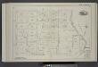
Vol. 2. Plate, C. [Map bound by Division Pl., Newtown Creek, Orient St., Vandervoort Ave.; Including Amos St., Bennett St., Parker St., Benton St., Bullion St., Maspeth St., Porter Ave., Varick Ave., Stewart Ave., Cardner Ave., Scott Ave., Seneca Ave.]
from Detailed estate and old farm line atlas of the city of Brooklyn : complete in six volumes ... from official records, private plans, and actual surveys ... / by G.M. Hopkins, C.E.
Brooklyn, Vol. 1, 2nd Part, Double Page Plate No. 35; Part of Wards 17 & 18, Section 9-10; [Map bounded by Calyer St., Newtown Creek, Richardson St. (Amos St.), Manhattan Ave., Meeker Ave.; Including Humboldt St., Nassau St., Jewel St., Meserole Ave.,...
From Volume 1, part 2
Brooklyn, Vol. 3, Double Page Plate No. 20; Part of Ward 18, Section 10; [Map bounded by Newtown Creek, Stagg St.; Including Varick Ave., Grand St., Bennett St.]
from Wards 13, 14, 15, 16, 17, 18, 19, 27 & 28.
Plate 13: Bounded by Calyer Street, Front Street, Bridgewater Street, Meeker Avenue, Scott Avenue, Amos Street, Morgan Avenue, Division Place, Kingsland Avenue, Herbert Street, N. Henry Street, Meeker Avenue, Graham Avenue, Vancott Avenue, Jewel Street,
from Robinson's atlas of the city of Brooklyn, New York : embracing all territory within its corporate limits; from official records ... / by and under the supervision of E. Robinson and R.H. Pidgeon, civil engineers.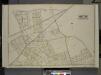
Queens, Vol. 2, Double Page Plate No. 22; Part of Ward Two Melvina; Maspeth, Linden Hill, East William Burg; [Map bounded by Maspeth Ave., Grand St., Flushing Ave., Fresh Pond Road; Including Mount Olivet Ave., Metropolitan Ave., Garrison A
from First and second wards: Long Island City and Newtown.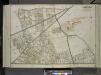
Queens, Vol. 2, Double Page Plate No. 32; Part of Ward Two Melvina Maspeth Linden Hill East Williamburgh; [Map bounded by Maspeth Ave., Grand St., Flushing Ave., Fresh Pond Road, Including Mount Olivet Ave., Metropolitan Ave., Grarrison Ave.,
from First and second wards: Long Island City and Newtown.
Plate 16: Bounded by (Newtown Creek) Seneca Avenue, Flushing Avenue, Grattan Street, Knickerbocker Avenue, Morgan Avenue, Amos Street, Gardner Avenue, Maspeth Avenue, Scott Street and Bullion Street.
from Atlas of the city of Brooklyn, New York.
Queens, Vol. 2, Double Page Plate No. 5; Part of Long Island City Ward One (Part of Old Ward Two) and Part of Newtown Ward Two; [Map bounded by Woodside Ave., Celtic Ave. (Highway to Calvary Cemetery), Hunters Point Ave.; Including Borden Ave.,
from First and second wards: Long Island City and Newtown.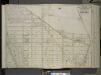
Queens, Vol. 2, Double Page Plate No. 5; Part of Long Island City Ward One (Part of Old Ward 2) Newtown Ward Two; [Map bounded by Woodside Ave., Celtic Ave. (Highway to Calvary Cemetery), Thomson Ave.; Including Greenpoint Ave., Bushwick
from First and second wards: Long Island City and Newtown.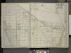
Queens, Vol. 2, Double Page Plate No. 5; Part of Long Island City Ward One (Part of Old Ward 2) and Part of Newtown Ward 2. [Map bounded by Middleburg Ave., Woodside Ave., Celtic (Highway to Calvary Cemetery) Ave., Bushwick and Newtown Turnpike
from Long Island City.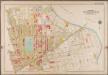
Plate 13: [Bounded by Calyer Street, Front Street (Newtown Creek), Bridgewater Street, Meeker Avenue, Gardiner Avenue, Townsend Street, Scott Avenue, Division Place, Gardiner Avenue, Amos Street, Morgan Avenue, Division Place, Kingsland Avenue, Herbert Street, N. Henry Street, Meeker Avenue, Graham Avenue, Driggs Street, Newell Street, Norman Avenue and Diamond Street.]; Atlas of the borough of Brooklyn, city of New York: from actual surveys and official plans by George W. and Walter S. Bromley.
from Atlas of the borough of Brooklyn, city of New York : from actual surveys and official plans by George W. and Walter S. Bromley. G.W. Bromley & Co.,
Plate 16: [Bounded by Newton Creek (Seneca Avenue), Grand Street, Gardner Avenue, Metropolitan Avenue, Scott Avenue, Meserole Street, Seneca Avenue, Purdy Place, Flushing Avenue, Knickerbocker Avenue, Morgan Avenue and Amos Street.]; Atlas of the borough of Brooklyn, city of New York: from actual surveys and official plans by George W. and Walter S. Bromley.
from Atlas of the borough of Brooklyn, city of New York : from actual surveys and official plans by George W. and Walter S. Bromley. G.W. Bromley & Co.,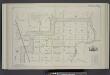
Vol. 2. Plate, E. [Map bound by Orient Ave., City Line, Meadow St., Canal, Vandervoort Ave.; Including Calhoun St., Dickinson St., Mill St., Grand St., Maujer St., Ten Eyck St., Porter Ave., Varick Ave., Metropolitan Ave., Stewart Ave., Gardner Ave., Sco
from Detailed estate and old farm line atlas of the city of Brooklyn : complete in six volumes ... from official records, private plans, and actual surveys ... / by G.M. Hopkins, C.E.
![Queens, Vol. 2, Double Page Plate No. 21; Part od Ward Two Laurel Hill; [Map bounded by Newtown Ave., Berlin Ave., Newtown Creek; Including Laurel Hill Ave., Laurel Hill Boulevard]; Sub Plan No. 1; [Map bounded by Newtown Ave., Maurice Ave., Old](https://images-0.georeferencer.com/images/iiif/811365484098/full/,300/0/native.jpg)

