Maps of Kings County
Plate 26: Part of Wards 17 & 18. City of Brooklyn.
from Atlas of the entire city of Brooklyn, complete in one volume. From actual surveys and official records by G. W. Bromley & Co.
Part of Wards 17 & 18. Land Map Sections, No. 9 & 10, Volume 1, Brooklyn Borough, New York City.
from Atlas of the Brooklyn borough of the City of New York : originally Kings Co.; complete in three volumes ... based upon official maps and plans ... / by and under the supervision of Hugo Ullitz, C.E.
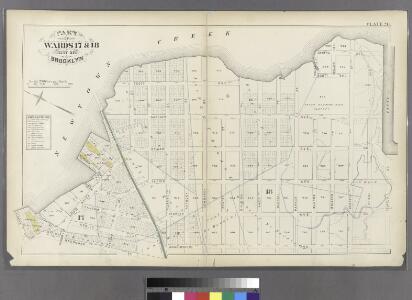
Brooklyn, Vol. 1, 2nd Part, Double Page Plate No. 35; Part of Wards 17 & 18, Section 9-10; [Map bounded by Calyer St., Newtown Creek, Richardson St. (Amos St.), Manhattan Ave., Meeker Ave.; Including Humboldt St., Nassau St., Jewel St., Meserole Ave.,...
From Volume 1, part 2
Plate 13: Bounded by Calyer Street, Front Street, Bridgewater Street, Meeker Avenue, Scott Avenue, Amos Street, Morgan Avenue, Division Place, Kingsland Avenue, Herbert Street, N. Henry Street, Meeker Avenue, Graham Avenue, Vancott Avenue, Jewel Street,
from Robinson's atlas of the city of Brooklyn, New York : embracing all territory within its corporate limits; from official records ... / by and under the supervision of E. Robinson and R.H. Pidgeon, civil engineers.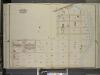
Brooklyn, Vol. 3, Double Page Plate No. 18; Part of Ward 18, Section 10; [Map bounded by Meeker Ave., Newtown Creek, Bennett St.; Including Morgan Ave., Lombardy St., Stewart Ave.]
from Wards 13, 14, 15, 16, 17, 18, 19, 27 & 28.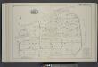
Vol. 2. Plate, B. [Map bound by Meeker Ave., Newtown Creek, Division Pl., Vandervoort Ave.; Including Townsend St., Thomas St., Cherry St., Anthony St., Lombardy St., Beadel St., Porter Ave., Varick Aver, Stewart Ave., Cardner Ave., Scott Ave.]
from Detailed estate and old farm line atlas of the city of Brooklyn : complete in six volumes ... from official records, private plans, and actual surveys ... / by G.M. Hopkins, C.E.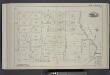
Vol. 2. Plate, C. [Map bound by Division Pl., Newtown Creek, Orient St., Vandervoort Ave.; Including Amos St., Bennett St., Parker St., Benton St., Bullion St., Maspeth St., Porter Ave., Varick Ave., Stewart Ave., Cardner Ave., Scott Ave., Seneca Ave.]
from Detailed estate and old farm line atlas of the city of Brooklyn : complete in six volumes ... from official records, private plans, and actual surveys ... / by G.M. Hopkins, C.E.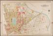
Plate 13: [Bounded by Calyer Street, Front Street (Newtown Creek), Bridgewater Street, Meeker Avenue, Gardiner Avenue, Townsend Street, Scott Avenue, Division Place, Gardiner Avenue, Amos Street, Morgan Avenue, Division Place, Kingsland Avenue, Herbert Street, N. Henry Street, Meeker Avenue, Graham Avenue, Driggs Street, Newell Street, Norman Avenue and Diamond Street.]; Atlas of the borough of Brooklyn, city of New York: from actual surveys and official plans by George W. and Walter S. Bromley.
from Atlas of the borough of Brooklyn, city of New York : from actual surveys and official plans by George W. and Walter S. Bromley. G.W. Bromley & Co.,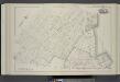
Vol. 6. Plate, G. [Map bound by Norman Ave. Kingsland Ave., Meserole Ave., Charlick St., Newtown Creek, Meeker Ave., Van Pelt Ave., N. Henry St., Van Cott Ave., Russell St.; Including Webster St., Pollock St., Nassau Ave., Monitor St., Sutton St., Morgan
from Detailed estate and old farm line atlas of the city of Brooklyn : complete in six volumes ... from official records, private plans, and actual surveys ... / by G.M. Hopkins, C.E.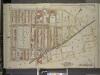
Brooklyn, Vol. 3, Double Page Plate No. 16; Part of Ward 17 & 18, Section 9 & 10; [Map bounded by Norman Ave., Bridgewater St., Vandam St., Newtown Creek Including Stewart St., Lombardy St., Engert Ave. (van Pelt Ave.), Homboldt St.]; Sub Plan
from Wards 13, 14, 15, 16, 17, 18, 19, 27 & 28.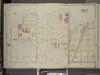
Brooklyn, Vol. 3, Double Page Plate No. 20; Part of Ward 18, Section 10; [Map bounded by Newtown Creek, Stagg St.; Including Varick Ave., Grand St., Bennett St.]
from Wards 13, 14, 15, 16, 17, 18, 19, 27 & 28.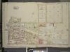
Brooklyn, Vol. 3, Double Page Plate No. 19; Part of Ward 18, Section 10; [Map bounded by Bennett St., Varick Ave., Maspeth Ave., Grand St., Bushwick Ave.; Including Old Woodpoint Rd., Skillman Ave., Kingland Ave.]
from Wards 13, 14, 15, 16, 17, 18, 19, 27 & 28.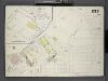
Brooklyn, V. 9, Double Page Plate No. 233 [Map bounded by New Town Creek, Nassau Ave., Sutton St., Vail St.]
From Atlas 89. Vol. 9, 1888.
Brooklyn V. 9, Plate No. 82 [Map bounded by Maspeth Ave., Newtown Creek, Grand St., Scott Ave.]
From Atlas 90. Vol. 9, 1907.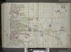
Brooklyn, Vol. 1, 2nd Part, Double Page Plate No. 36; Part of Wards 16 & 18, Section 10; [Map bounded by Richardson St. (Amos St.), Newtown Creek, Seneca Ave., Meserole Ave., Bushwick Ave.; Including Old Woodpoint Rd., Skillman Ave., Humboldt St., Ric...
From Volume 1
Part of Wards 16 & 18, Land Map Section, No. 10, Volume 1. Brooklyn Borough, New York City.
from Atlas of the Brooklyn borough of the City of New York : originally Kings Co.; complete in three volumes ... based upon official maps and plans ... / by and under the supervision of Hugo Ullitz, C.E.
Plate 16: Bounded by (Newtown Creek) Seneca Avenue, Flushing Avenue, Grattan Street, Knickerbocker Avenue, Morgan Avenue, Amos Street, Gardner Avenue, Maspeth Avenue, Scott Street and Bullion Street.
from Atlas of the city of Brooklyn, New York.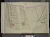
Queens, Vol. 2, Double Page Plate No. 21; Part od Ward Two Laurel Hill; [Map bounded by Newtown Ave., Berlin Ave., Newtown Creek; Including Laurel Hill Ave., Laurel Hill Boulevard]; Sub Plan No. 1; [Map bounded by Newtown Ave., Maurice Ave., Old
from First and second wards: Long Island City and Newtown.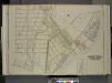
Queens, Vol. 2, Double Page Plate No. 4; Part of Long Island City Ward One (Part of Old Wards One and Two); [Map bounded by Van Pelt St., Greenpoint Ave., Hunters Point Ave., Borden Ave., Bradlay Ave.; Including Newtown Creek, Water St., Proposed
from First and second wards: Long Island City and Newtown.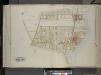
Queens, Vol. 2, Double Page Plate No. 30; Part of Ward Two Laurel Hill; [Map bounded by Berlin Ave., Newtown Creek, Laurel Hill Boulevard; Including Newtown Ave., Old Brook School Road, Newtown Turnpike]
from First and second wards: Long Island City and Newtown.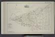
Vol. 2. Plate, A. [Map bound by Bayard (Sanford) St., Meeker Ave., Vandervoort Ave., Parker Pl., Kingsland Ave., Frost St., Humboldt Ave., Richardson St., Ewen St.; Including Herbert St., Anthony St., Lombard St., Beadel St., Division St., Amos St., Benn
from Detailed estate and old farm line atlas of the city of Brooklyn : complete in six volumes ... from official records, private plans, and actual surveys ... / by G.M. Hopkins, C.E.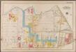
Plate 16: [Bounded by Newton Creek (Seneca Avenue), Grand Street, Gardner Avenue, Metropolitan Avenue, Scott Avenue, Meserole Street, Seneca Avenue, Purdy Place, Flushing Avenue, Knickerbocker Avenue, Morgan Avenue and Amos Street.]; Atlas of the borough of Brooklyn, city of New York: from actual surveys and official plans by George W. and Walter S. Bromley.
from Atlas of the borough of Brooklyn, city of New York : from actual surveys and official plans by George W. and Walter S. Bromley. G.W. Bromley & Co.,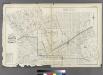
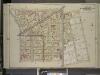
Plate 25: Part of Wards 15, 17, &18. City of Brooklyn.
from Atlas of the entire city of Brooklyn, complete in one volume. From actual surveys and official records by G. W. Bromley & Co.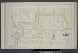
Vol. 2. Plate, E. [Map bound by Orient Ave., City Line, Meadow St., Canal, Vandervoort Ave.; Including Calhoun St., Dickinson St., Mill St., Grand St., Maujer St., Ten Eyck St., Porter Ave., Varick Ave., Metropolitan Ave., Stewart Ave., Gardner Ave., Sco
from Detailed estate and old farm line atlas of the city of Brooklyn : complete in six volumes ... from official records, private plans, and actual surveys ... / by G.M. Hopkins, C.E.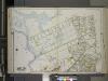
Queens, Vol. 2A, Double Page Plate No. 14; Part of Ward Two Newtown. [Map bounded by Maspeth Creek, Creek St., Maspeth Ave., Broad St., Pacific St.; Including Andrews St., Metropolitan Ave., newtown Creek] / by and under the supervision of Hugo Ullitz.
From v. 2A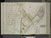
Queens, Vol. 2, Double Page Plate No. 4; Part of Long Island City Ward One (Part of Old Wards 1 and 2); [Map bounded by Van Pelt St., Greenpoint Ave., Hunters Point Ave., Borden Ave., Howard St., Spring St., Preston St.; Including Pine St., Va
from First and second wards: Long Island City and Newtown.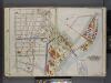
Queens, V. 2, Double Page Plate No. 4; Part of Long Island City, Ward 1; [Map bounded by Van Pelt St., Newtown Creek, Dutch Kills Canal, Nelson Ave.] / by and under the supervision of Hugo Ullitz.
From v. 2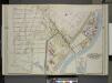
Queens, Vol. 2, Double Page Plate No. 4; Part of Long Island City Ward One (Part of Old Wards 1 & 2 ) Sub Plan; [Map bounded by Water St., Marsh St., Proposed Canal]; Part of Long Island City Ward One (Part of Old Wards 1 & 2 ) [Map bounded by Nott
from Long Island City.
Plate 14: Part of Wards 15, 17 & 18. Brooklyn, N.Y.
from Robinson's atlas of the city of Brooklyn, New York : embracing all territory within its corporate limits; from official records ... / by and under the supervision of E. Robinson and R.H. Pidgeon, civil engineers.