Maps of Kings County

Brooklyn V. 9, Plate No. 82 [Map bounded by Maspeth Ave., Newtown Creek, Grand St., Scott Ave.]
From Atlas 90. Vol. 9, 1907.
Brooklyn V. 9, Plate No. 80 [Map bounded by Newtown Creek, Stagg St., Stewart Ave., Grand St.]
From Atlas 90. Vol. 9, 1907.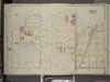
Brooklyn, Vol. 3, Double Page Plate No. 20; Part of Ward 18, Section 10; [Map bounded by Newtown Creek, Stagg St.; Including Varick Ave., Grand St., Bennett St.]
from Wards 13, 14, 15, 16, 17, 18, 19, 27 & 28.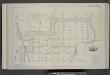
Vol. 2. Plate, E. [Map bound by Orient Ave., City Line, Meadow St., Canal, Vandervoort Ave.; Including Calhoun St., Dickinson St., Mill St., Grand St., Maujer St., Ten Eyck St., Porter Ave., Varick Ave., Metropolitan Ave., Stewart Ave., Gardner Ave., Sco
from Detailed estate and old farm line atlas of the city of Brooklyn : complete in six volumes ... from official records, private plans, and actual surveys ... / by G.M. Hopkins, C.E.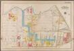
Plate 16: [Bounded by Newton Creek (Seneca Avenue), Grand Street, Gardner Avenue, Metropolitan Avenue, Scott Avenue, Meserole Street, Seneca Avenue, Purdy Place, Flushing Avenue, Knickerbocker Avenue, Morgan Avenue and Amos Street.]; Atlas of the borough of Brooklyn, city of New York: from actual surveys and official plans by George W. and Walter S. Bromley.
from Atlas of the borough of Brooklyn, city of New York : from actual surveys and official plans by George W. and Walter S. Bromley. G.W. Bromley & Co.,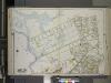
Queens, Vol. 2A, Double Page Plate No. 14; Part of Ward Two Newtown. [Map bounded by Maspeth Creek, Creek St., Maspeth Ave., Broad St., Pacific St.; Including Andrews St., Metropolitan Ave., newtown Creek] / by and under the supervision of Hugo Ullitz.
From v. 2A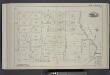
Vol. 2. Plate, C. [Map bound by Division Pl., Newtown Creek, Orient St., Vandervoort Ave.; Including Amos St., Bennett St., Parker St., Benton St., Bullion St., Maspeth St., Porter Ave., Varick Ave., Stewart Ave., Cardner Ave., Scott Ave., Seneca Ave.]
from Detailed estate and old farm line atlas of the city of Brooklyn : complete in six volumes ... from official records, private plans, and actual surveys ... / by G.M. Hopkins, C.E.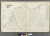
Plate 26: Part of Wards 17 & 18. City of Brooklyn.
from Atlas of the entire city of Brooklyn, complete in one volume. From actual surveys and official records by G. W. Bromley & Co.
Part of Wards 16 & 18, Land Map Section, No. 10, Volume 1. Brooklyn Borough, New York City.
from Atlas of the Brooklyn borough of the City of New York : originally Kings Co.; complete in three volumes ... based upon official maps and plans ... / by and under the supervision of Hugo Ullitz, C.E.
Plate 16: Bounded by (Newtown Creek) Seneca Avenue, Flushing Avenue, Grattan Street, Knickerbocker Avenue, Morgan Avenue, Amos Street, Gardner Avenue, Maspeth Avenue, Scott Street and Bullion Street.
from Atlas of the city of Brooklyn, New York.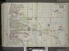
Brooklyn, Vol. 1, 2nd Part, Double Page Plate No. 36; Part of Wards 16 & 18, Section 10; [Map bounded by Richardson St. (Amos St.), Newtown Creek, Seneca Ave., Meserole Ave., Bushwick Ave.; Including Old Woodpoint Rd., Skillman Ave., Humboldt St., Ric...
From Volume 1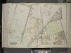
Queens, Vol. 2, Double Page Plate No. 33; Part of Ward Two Newtown; [Map bounded by Flushing Ave., Union Ave., Carrison Ave., Flushing Ave., Metropolitan Ave.; Including Stanhope St. (Summit St.), Boundary Line between boroughs of Queens and
from First and second wards: Long Island City and Newtown.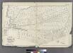
[Plate 30: Bounded by Seneca Avenue, Covert Street, Suydam Street, Cypress Avenue, Harman Street, St. Nicholas Avenue, Grove Street, Myrtle Avenue, Ralph Street, Knickerbocker Avenue, Bleecker Street, Hamburg Avenue, Harman Street, Central Avenue, Flushi
from Atlas of the entire city of Brooklyn, complete in one volume. From actual surveys and official records by G. W. Bromley & Co.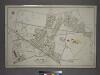
[Plate 7: Bounded by Maspeth Avenue, Maurice Avenue, Juniper Avenue, (Mount Olivet Cemetery) Fresh Pond Avenue, Metropolitan Avenue, Stanhope Street, Woodard Avenue,(Newtown Creek) Grand Street and Flushing Avenue.]
from Atlas of the city of New York, borough of Queens, Long Island City, Newtown, Flushing, Jamaica, Far Rockaway, from actual surveys and official plans / by George W. and Walter S. Bromley.
13A - N.Y. City (Aerial Set).
from Sectional aerial maps of the City of New York / [photographed and assembled under the direction of the chief engineer, July 1st, 1924].
13C - N.Y. City (Aerial Set).
from Sectional aerial maps of the City of New York / [photographed and assembled under the direction of the chief engineer, July 1st, 1924].
Plan of the city of Brooklyn, L.I. / by William Perris.
from Brooklyn
Plan of the city of Brooklyn, L.I. / by William Perris.
from Brooklyn
Sheet 8: Map encompassing Greenpoint and North Williamsburg.
from Map of the city of Brooklyn : being the former cities of Brooklyn & Williamsburgh and the town of Bushwick, as consolidated January 1st, 1855 by an act of the legislature of the State of New York ... showing also a part of the City of New York.
Sheet 7: Map encompassing Williamsburg, E. Williamsburg and Bushwick.
from Map of the city of Brooklyn : being the former cities of Brooklyn & Williamsburgh and the town of Bushwick, as consolidated January 1st, 1855 by an act of the legislature of the State of New York ... showing also a part of the City of New York.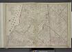
Brooklyn, Double Page Section 4; [Including Wards 16, 18, 19, 21, 25]
from Farm line map of the city of Brooklyn, from official records and surveys; comp. and drawn by Henry Fulton.
Height District Map Section No. 13; Height district map / City of New York, Board of Estimate and Apportionment.
from Height district map / City of New York, Board of Estimate and Apportionment. New York (N.Y.). Board of Estimate and Apportionment,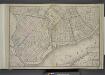
Brooklyn, Double Page Section 1; [Including wards 13, 14, 15, 16, 17, 18, 19]
from Farm line map of the city of Brooklyn, from official records and surveys; comp. and drawn by Henry Fulton.
Plan of the city of Brooklyn, L.I. / by William Perris.
from Brooklyn
Plan of the city of Brooklyn, L.I. / by William Perris.
from Brooklyn
Key
From Atlas 137a. Vol. 3, 1914.
Liqordom in New York City.
From Manhattan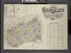
Insurance Maps of the Brooklyn city of New York Volume Four. Published by the Sanborn map co. 117, Broadway, New York. 1887.
From Atlas 74. Vol. 4, 1887.
Plate 40: Bounded by Corlears Street, Pierhead Line [Piers 45-1], Battery Park, Whitehall Street, and South Street.
from Atlas of the borough of Manhattan, city of New York.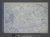
![Brooklyn V. 9, Plate No. 82 [Map bounded by Maspeth Ave., Newtown Creek, Grand St., Scott Ave.]](https://images-2.georeferencer.com/images/iiif/685470239016/full/,300/0/native.jpg)

