Maps of Queens County
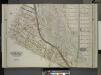
Queens, Vol. 2, Double Page Plate No. 5; Part of Long Island City Ward One (Part of Old Ward 2) and Part of Newtown Ward 2. [Map bounded by Middleburg Ave., Woodside Ave., Celtic (Highway to Calvary Cemetery) Ave., Bushwick and Newtown Turnpike
from Long Island City.
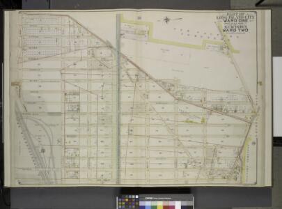
Queens, Vol. 2, Double Page Plate No. 5; Part of Long Island City Ward One (Part of Old Ward 2) Newtown Ward Two; [Map bounded by Woodside Ave., Celtic Ave. (Highway to Calvary Cemetery), Thomson Ave.; Including Greenpoint Ave., Bushwick
from First and second wards: Long Island City and Newtown.
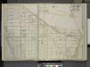
Queens, Vol. 2, Double Page Plate No. 5; Part of Long Island City Ward One (Part of Old Ward Two) and Part of Newtown Ward Two; [Map bounded by Woodside Ave., Celtic Ave. (Highway to Calvary Cemetery), Hunters Point Ave.; Including Borden Ave.,
from First and second wards: Long Island City and Newtown.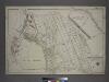
Part of the Borough of Queens, Long Island City, Ward 1.
from Atlas of the city of New York, borough of Queens, Long Island City, Newtown, Flushing, Jamaica, Far Rockaway, from actual surveys and official plans / by George W. and Walter S. Bromley.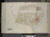
Queens, Vol. 2, Double Page Plate No. 30; Part of Ward Two Laurel Hill; [Map bounded by Berlin Ave., Newtown Creek, Laurel Hill Boulevard; Including Newtown Ave., Old Brook School Road, Newtown Turnpike]
from First and second wards: Long Island City and Newtown.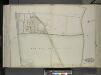
Queens, vol. 2, Double Page Plate No. 29; Part of Ward Two Newtown; [Map bounded by Greenpoint Ave., Newtown and Bushwick Turnpike (Shell Road), Maurice Ave.; Including Newtown Ave. (Penny Bride Road), Betts Ave., Thomson Ave.]
from First and second wards: Long Island City and Newtown.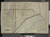
Queens, Vol. 2, Double Page No. 6; Part of Long Island City Ward One (Part of Old Ward 2 & 4) Sub Plan; [Map bounded by Harold Ave., Middleburg Ave.; Including Bragaw St., Lowery St., Van Buren St., Van Pelt St.]; Part of Long Island City Ward
from Long Island City.
Queens, Vol. 2, Double Page Plate No. 6; Part of Long Island City Ward One (Part of Wards 2 and 4); [Map bounded by Jamaica Ave., North Wood Side, Middleburg Ave., Laurel Hill Ave., Madden St., Van Buren St., Lowery St., Bragaw St.; Including H
from First and second wards: Long Island City and Newtown.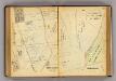
130-131 Greenburgh.
1 : 7200 G.W. Bromley & Co.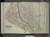
Queens, Vol. 2, Double Page Plate No. 3; Part of Long Island City Ward One (Part of Old Wards 2, 3 and 4); [Map bounded by Washington Ae., Pomeroy St. (8th Ave.), Jackson Ave., Skillman Ave., Van Pelt St., Nott Ave.; Including Thomson Ave., Purve
from First and second wards: Long Island City and Newtown.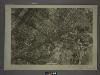
9C - N.Y. City (Aerial Set).
from Sectional aerial maps of the City of New York / [photographed and assembled under the direction of the chief engineer, July 1st, 1924].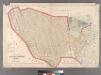
Part of Long Island City, Ward No. 2.
from Atlas of Queens Co., Long Island, New York / compiled from official records, private plans & actual surveys by and under the direction of Chester Wolverton.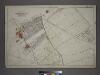
Part of the Borough of Queens, New town, Ward 2.
from Atlas of the city of New York, borough of Queens, Long Island City, Newtown, Flushing, Jamaica, Far Rockaway, from actual surveys and official plans / by George W. and Walter S. Bromley.
Sheet 8: Map encompassing Greenpoint and North Williamsburg.
from Map of the city of Brooklyn : being the former cities of Brooklyn & Williamsburgh and the town of Bushwick, as consolidated January 1st, 1855 by an act of the legislature of the State of New York ... showing also a part of the City of New York.
Plan of the city of Brooklyn, L.I. / by William Perris.
from Brooklyn
Area District Map Section No. 9; Area district map / City of New York, Board of Estimate and Apportionment.
from Area district map / City of New York, Board of Estimate and Apportionment. New York (N.Y.). Board of Estimate and Apportionment,
Height District Map Section No. 9; Height district map / City of New York, Board of Estimate and Apportionment.
from Height district map / City of New York, Board of Estimate and Apportionment. New York (N.Y.). Board of Estimate and Apportionment,
[Plate 4: Bounded by Rapelje Avenue, Woolsey Avenue, Flushing Avenue, Old Bowery Bay Road, Woodside Avenue, Middleburg Avenue, Celtic (Woodside) Avenue, Foster Avenue, Laurel Hill Avenue, Skillman Avenue, Harold Avenue and Jackson Avenue.]
from Atlas of the city of New York, borough of Queens, Long Island City, Newtown, Flushing, Jamaica, Far Rockaway, from actual surveys and official plans / by George W. and Walter S. Bromley.
13A - N.Y. City (Aerial Set).
from Sectional aerial maps of the City of New York / [photographed and assembled under the direction of the chief engineer, July 1st, 1924].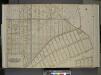
Queens, Vol. 2, Double Page Plate No. 6; Part of Long Island City Ward One (Part of Old Wards Two and Four); [Map bounded by Jamaica Ave., Old Bowery Bay Road, Woodside Ave., Middleburg Ave., Van Buren St., Lowery St.; Including Bragaw St., Harold S
from First and second wards: Long Island City and Newtown.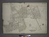
[Plate 13: Bounded by Astoria Road, Middleburg Avenue, Woodside Avenue, Bowery Bay Road, Jamaica Avenue, Grand Gleasonville Avenue, Charlotte Avenue, 10th Street, Jackson Avenue, Trains Meadow Road, Forest Street, Worthington Street, Woodside Avenue, Fis
from Atlas of the city of New York, borough of Queens, Long Island City, Newtown, Flushing, Jamaica, Far Rockaway, from actual surveys and official plans / by George W. and Walter S. Bromley.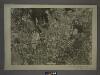
9D - N.Y. City (Aerial Set).
from Sectional aerial maps of the City of New York / [photographed and assembled under the direction of the chief engineer, July 1st, 1924].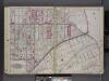
Queens, V. 2, Double Page Plate No. 6; Part of Long Island City, Ward 1; [Map bounded by Patterson Ave., Duane St., Woodside Ave., Middleburg Ave., Washington Ave., 4th Ave.] / by and under the supervision of Hugo Ullitz.
From v. 2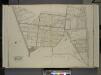
Queens, Vol. 2, Double Page Plate No. 13; Part of Ward two Woodside; [Map bounded by Jackson Ave., Solon St., Mecke St., Kelly Ave., Townsend St.; Including Greenpoint Ave., Thomson Ave., Astoria road (Celtic Ave.), Middleburg Ave., Woo
from First and second wards: Long Island City and Newtown.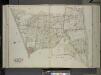
Queens, Vol. 2, Double Page Plate No. 15; Part of Ward Two Woodside; [Map bounded by Kelly Ave., Woodside Ave., Greepoint Ave., Thomson Ave.; Including Astoria Road (Highway to Calvary Cemetery) (Celtic Ave.), Middleburg Ave., Jackson Ave
from First and second wards: Long Island City and Newtown.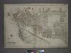
[Plate 1: Bounded by (East River) River Street, Dock Street, Front Street, Hunterspoint Avenue, West Avenue, Vernon Avenue, Freeman Avenue, Jackson Avenue, Thomson Avenue, Upton Street, Mott Avenue, Creek Street, Borden Avenue, Vernon and Flushing Street
from Atlas of the city of New York, borough of Queens, Long Island City, Newtown, Flushing, Jamaica, Far Rockaway, from actual surveys and official plans / by George W. and Walter S. Bromley.
Queens, Vol. 2, Double Page Plate No. 3; Part of Long Island City Ward One (Part of Old Wards Two, Three and Four); [Map bounded by Van Pelt St., Nott Ave., Creek St., Meadow St., Purves St., Hunter Ave., Prospect St.; Including Webster Ave
from First and second wards: Long Island City and Newtown.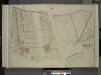
Queens, Vol. 2, Double Page Plate No. 21; Part od Ward Two Laurel Hill; [Map bounded by Newtown Ave., Berlin Ave., Newtown Creek; Including Laurel Hill Ave., Laurel Hill Boulevard]; Sub Plan No. 1; [Map bounded by Newtown Ave., Maurice Ave., Old
from First and second wards: Long Island City and Newtown.
Part of Long Island City, Ward No. 1 & 3.
from Atlas of Queens Co., Long Island, New York / compiled from official records, private plans & actual surveys by and under the direction of Chester Wolverton.