Maps of Kings County
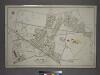
[Plate 7: Bounded by Maspeth Avenue, Maurice Avenue, Juniper Avenue, (Mount Olivet Cemetery) Fresh Pond Avenue, Metropolitan Avenue, Stanhope Street, Woodard Avenue,(Newtown Creek) Grand Street and Flushing Avenue.]
from Atlas of the city of New York, borough of Queens, Long Island City, Newtown, Flushing, Jamaica, Far Rockaway, from actual surveys and official plans / by George W. and Walter S. Bromley.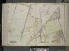
Queens, Vol. 2, Double Page Plate No. 33; Part of Ward Two Newtown; [Map bounded by Flushing Ave., Union Ave., Carrison Ave., Flushing Ave., Metropolitan Ave.; Including Stanhope St. (Summit St.), Boundary Line between boroughs of Queens and
from First and second wards: Long Island City and Newtown.
Queens V. 3, Plate No. 58 [Map bounded by Maurice Ave., Jackson Ave., Jefferson Ave., North Hempstead Plank Rd., Lexington Ave.]
From Atlas 137. Vol. 3, 1902.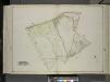
Queens, Vol. 2, Double Page Plate No. 31; Part of Ward two Newtown; [Map bounded by Newtown Ave., Covert Ave. (Betts Ave.), Old Brook School Road, Maurice Ave.; Including Astoria Ave., Maspeth Ave., Road to Town Landing, Berlin Ave.]
from First and second wards: Long Island City and Newtown.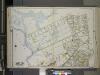
Queens, Vol. 2A, Double Page Plate No. 14; Part of Ward Two Newtown. [Map bounded by Maspeth Creek, Creek St., Maspeth Ave., Broad St., Pacific St.; Including Andrews St., Metropolitan Ave., newtown Creek] / by and under the supervision of Hugo Ullitz.
From v. 2A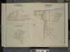
Queens, Vol. 2, Double Page Plate No. 27; Part of Ward Two St. Williamburgh; [Map bounded by Vermont Ave., Crosby Ave.; Including Highland Boulevard]; Part of Ward Two Nassau Hights; [Map bounded by Grand St., Maiden Lane, Firth Ave.; Including
from First and second wards: Long Island City and Newtown.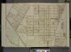
Queens, Vol. 2, Double Page Plate No. 23; Part of Ward Two East Williamsburgh; [Map bounded by Putnam Ave., Madison St., Boundary Line Between Borough of Queens and Brooklyn, Suydam St., Woodard Ave.; Including Metropolitan Ave., Fresh Pond Road,
from First and second wards: Long Island City and Newtown.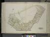
Queens, Vol. 2, Double Page Plate No. 28; Part of Ward Two Maspeth; [Map bounded by Maurice Ave., Fisk Ave., Grand St.; Including Maspeth Ave., Astoria Ave.]
from First and second wards: Long Island City and Newtown.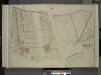
Queens, Vol. 2, Double Page Plate No. 21; Part od Ward Two Laurel Hill; [Map bounded by Newtown Ave., Berlin Ave., Newtown Creek; Including Laurel Hill Ave., Laurel Hill Boulevard]; Sub Plan No. 1; [Map bounded by Newtown Ave., Maurice Ave., Old
from First and second wards: Long Island City and Newtown.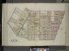
Queens, Vol. 2, Double Page Plate No. 34; Part of Ward Two East Williamsburgh; [Map bounded by Palmetto St., Prospect Ave., Ivy St., Forest Ave., Ptnan Ave., Woodard Ave., Madison St., Myrtle Ave.; Including Boundary Line between borough of Qu
from First and second wards: Long Island City and Newtown.
Queens, Vol. 2, Double Page Plate No. 38; Part of Ward Two Newtown; [Map bounded by Mt. Olivet Ave., Way Ave., Juniper Ave.; Including Metropolitan Ave., Fresh Pond Road.]
from First and second wards: Long Island City and Newtown.
Queens, Vol. 2, Double Page Plate No. 22; Part of Ward Two Melvina; Maspeth, Linden Hill, East William Burg; [Map bounded by Maspeth Ave., Grand St., Flushing Ave., Fresh Pond Road; Including Mount Olivet Ave., Metropolitan Ave., Garrison A
from First and second wards: Long Island City and Newtown.
Queens, Vol. 2, Double Page Plate No. 32; Part of Ward Two Melvina Maspeth Linden Hill East Williamburgh; [Map bounded by Maspeth Ave., Grand St., Flushing Ave., Fresh Pond Road, Including Mount Olivet Ave., Metropolitan Ave., Grarrison Ave.,
from First and second wards: Long Island City and Newtown.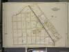
Brooklyn, Vol. 3, Double Page Plate No. 22; Part of Wards 18 & 27, Sections 10 & 11; [Map bounded by Newtown Creek, Troutman St.; Including Irving Ave., Varick Ave., Stagg St.]
from Wards 13, 14, 15, 16, 17, 18, 19, 27 & 28.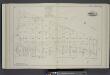
Vol. 2. Plate, K. [Map bound by City Line, Greene St., Wyckoff Ave., Flushing Ave.; Including Covert Ave., Cypress Ave., St. Nicholas Ave., Jefferson St., Troutman St., Starr St., Myrtle St., Suydam St., Elm St., De Kalb Ave., Stockholm St., Stanhope St.
from Detailed estate and old farm line atlas of the city of Brooklyn : complete in six volumes ... from official records, private plans, and actual surveys ... / by G.M. Hopkins, C.E.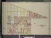
Brooklyn, Vol. 3, Double Page Plate No. 26; Part of Wards 27 & 28, Section 11; [Map bounded by Boundry Line of Borough of Brooklyn and Queens, Ralph St., St.Nicholas Ave.; Including Stanhope St., Irving Ave., Troutman St.]
from Wards 13, 14, 15, 16, 17, 18, 19, 27 & 28.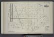
Vol. 2. Plate, H. [Map bound by Meadow St., Metropolitan Ave., City Line, Flushing Ave., Ingraham St., Vandervoort Ave., Canal; Including Stagg St., Scholes St., Meserole St., Montrose Ave., Randolph St., Johnson Ave., Porter Ave., Varick Ave., Stewart A
from Detailed estate and old farm line atlas of the city of Brooklyn : complete in six volumes ... from official records, private plans, and actual surveys ... / by G.M. Hopkins, C.E.
Plate 16: Bounded by (Newtown Creek) Seneca Avenue, Flushing Avenue, Grattan Street, Knickerbocker Avenue, Morgan Avenue, Amos Street, Gardner Avenue, Maspeth Avenue, Scott Street and Bullion Street.
from Atlas of the city of Brooklyn, New York.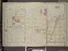
Brooklyn, Vol. 3, Double Page Plate No. 20; Part of Ward 18, Section 10; [Map bounded by Newtown Creek, Stagg St.; Including Varick Ave., Grand St., Bennett St.]
from Wards 13, 14, 15, 16, 17, 18, 19, 27 & 28.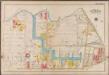
Plate 16: [Bounded by Newton Creek (Seneca Avenue), Grand Street, Gardner Avenue, Metropolitan Avenue, Scott Avenue, Meserole Street, Seneca Avenue, Purdy Place, Flushing Avenue, Knickerbocker Avenue, Morgan Avenue and Amos Street.]; Atlas of the borough of Brooklyn, city of New York: from actual surveys and official plans by George W. and Walter S. Bromley.
from Atlas of the borough of Brooklyn, city of New York : from actual surveys and official plans by George W. and Walter S. Bromley. G.W. Bromley & Co.,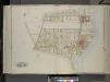
Queens, Vol. 2, Double Page Plate No. 30; Part of Ward Two Laurel Hill; [Map bounded by Berlin Ave., Newtown Creek, Laurel Hill Boulevard; Including Newtown Ave., Old Brook School Road, Newtown Turnpike]
from First and second wards: Long Island City and Newtown.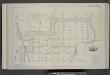
Vol. 2. Plate, E. [Map bound by Orient Ave., City Line, Meadow St., Canal, Vandervoort Ave.; Including Calhoun St., Dickinson St., Mill St., Grand St., Maujer St., Ten Eyck St., Porter Ave., Varick Ave., Metropolitan Ave., Stewart Ave., Gardner Ave., Sco
from Detailed estate and old farm line atlas of the city of Brooklyn : complete in six volumes ... from official records, private plans, and actual surveys ... / by G.M. Hopkins, C.E.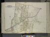
Queens, Vol. 2, Double Page Plate No. 27; Part of Ward Two Maspeth and Nassau Heights; [Map bounded by Calamus Road (Penny Bridge), Calamus Ave., grand St., North Hempstead Plank Road, Johnson Ave., Maiden Lane; Including Fulton St.,
from First and second wards: Long Island City and Newtown.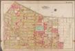
Plate 17: [Bounded by Flushing Avenue, Purdy Place, Willoughby Avenue, Cypress Avenue, Himrod Street, St. Nicholas Avenue, Harman Street, Bushwick Avenue and Bremen Street.]; Atlas of the borough of Brooklyn, city of New York: from actual surveys and official plans by George W. and Walter S. Bromley.
from Atlas of the borough of Brooklyn, city of New York : from actual surveys and official plans by George W. and Walter S. Bromley. G.W. Bromley & Co.,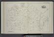
Vol. 2. Plate, J. [Map bound by Bogart St., Thames St., Vandervoort Aver, Ingraham St., Gardner Aver, Flushing Ave., Wyckoff Ave., Starr St., Central Ave.; Including Rock St., Forest St., Prospect St., George St., Melrose St., Jefferson St., Troutman St.
from Detailed estate and old farm line atlas of the city of Brooklyn : complete in six volumes ... from official records, private plans, and actual surveys ... / by G.M. Hopkins, C.E.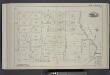
Vol. 2. Plate, C. [Map bound by Division Pl., Newtown Creek, Orient St., Vandervoort Ave.; Including Amos St., Bennett St., Parker St., Benton St., Bullion St., Maspeth St., Porter Ave., Varick Ave., Stewart Ave., Cardner Ave., Scott Ave., Seneca Ave.]
from Detailed estate and old farm line atlas of the city of Brooklyn : complete in six volumes ... from official records, private plans, and actual surveys ... / by G.M. Hopkins, C.E.
Brooklyn V. 9, Plate No. 49 [Map bounded by St.Nicholas Ave., Stockholm St., Irving Ave., Willoughby Ave.]
From Atlas 90. Vol. 9, 1907.
Brooklyn Vol. A Plate No. 94 [Map bounded by Harman St., Onderdonk Ave., Grove St., St. Nicholas Ave.]
From Atlas 61. Vol. A, 1893.
Brooklyn Vol. A Plate No. 91 [Map bounded by Onderdonk Ave., Bleeoker St., Fairview Ave.]
From Atlas 61. Vol. A, 1893.
![[Plate 7: Bounded by Maspeth Avenue, Maurice Avenue, Juniper Avenue, (Mount Olivet Cemetery) Fresh Pond Avenue, Metropolitan Avenue, Stanhope Street, Woodard Avenue,(Newtown Creek) Grand Street and Flushing Avenue.]](https://images-2.georeferencer.com/images/iiif/077359930186/full/,300/0/native.jpg)

